
Population 2,365 (2011) Civil parish Ixworth | OS grid reference TL934704 Sovereign state United Kingdom District St Edmundsbury | |
 | ||
Ixworth cycle races promotional video 2014
Ixworth is a village and civil parish in the Borough of St Edmundsbury in the English county of Suffolk. It is 6 miles (9.7 km) north-east of Bury St Edmunds and 9 miles (14 km) south-east of Thetford on the A143 road to Diss. The parish has a population of 2,177, increasing to 2,365 at the 2011 Census. The south end of High Street and town may also be historically listed as Ixworth St Mary.
Contents
- Ixworth cycle races promotional video 2014
- Map of Ixworth Bury Saint Edmunds UK
- Fountain in ixworth high street just infront of my home
- History
- Modern Ixworth
- Government
- Education
- Bangrove Wood SSSI
- References
Map of Ixworth, Bury Saint Edmunds, UK
Fountain in ixworth high street just infront of my home
History
Ixworth was settled in Roman times and was the site of a 1st century AD Roman fort. The fort is believed to have been built as a response to Boudicca's revolt and appears to have been in use only until the end of the 1st century. The site measures 193 metres (633 ft) by 205 metres (673 ft) and was surrounded by three ditches.
After the fort went out of use a civilian settlement was established at the site, possibly with a pottery industry. Ixworth became an important junction in the Roman road system of East Anglia and the Peddars Way ran 48 miles (77 km) from Ixworth to Holme next the Sea on the north coast of Norfolk. The foundations of a Roman building with hypocaust were discovered in 1834 and are believed to be a villa and bath house complex.
An early pagan cemetery with Anglo-Saxon burial urns was discovered south-west of the church some time before 1849 and a number of other post-Roman archaeological finds have been discovered in the area. In 1856 the Ixworth Cross, a gold pectoral cross covered in garnets dating from the 7th century, was discovered in what is believed to be another Anglo-Saxon cemetery. The cross is decorated using cloisonné work and was donated to the Ashmolean Museum in Oxford in 1909. It was discovered in a rare bed burial.
The first recorded name for Ixworth is from 1025 as Gyxeweorde meaning "Enclosure of a man called Gisca". The settlement was recorded in the Domesday Book as "Icsewrda" or "Giswortha". The village, which was in the Hundred of Blackbourn, was relatively very large at this time with 51 households. It was held by Robert Blunt or Blount in 1086, having formed part of the lands controlled by the Abbey of Bury St Edmunds in 1066.
Ixworth Priory was founded as an Augustinian priory in about 1170 and dissolved in 1537. Remains of the priory include the almost complete east range whilst some of the west range can be found incorporated into a house, known as Ixworth Abbey. These remains are a Grade I listed building and include elements from the early 13th century.
Ixworth is the site the earliest rural council housing built in England. Four pairs of houses were built in 1893–94 for Thingoe Rural District Council, encouraged by the Ixworth Labourer's Association. These were built under the Housing of the Working Classes Act 1890, the first to allow rural councils to build their own housing. The act was only adopted by eight councils. The houses exist today in a largely unaltered condition. Two of them, on Stow Road, are Grade II listed buildings.
A Q Type bombing decoy was operated in the north-east of the parish to deflect enemy bombing from RAF Honington.
A former pumping station at Bailypool Lane off Stow Lane has been given planning permission as of 2012 for conversion to a residential dwelling.
Modern Ixworth
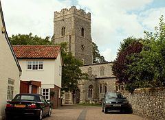
St Mary's Church lies just west of High Street. The church dates from the late 14th century with a late 15th century tower. It contains memorials to Richard Coddington who was granted the land owned by the priory following the dissolution. The church is a Grade I Listed Building.
The village contains a number of other listed buildings, many on the High Street, some of which have medieval elements. A variety of local services remain in the village, including shops, a post office and public houses as well as a village hall, doctor's surgery, a retained fire station and police station sharing the same building.
Ixworth is served by rural bus routes and is on the National Express London to Great Yarmouth coach route. The village was bypassed in 1986 when the A143 was diverted to run to the south-east of the village.
Government
Ixworth is in the Borough of St Edmundsbury and elects one borough councillor. It lies in the Blackbourn division of Suffolk County Council and the West Suffolk parliamentary constituency. The parish council jointly administers Ixworth and Ixworth Thorpe.
Education
Ixworth Primary School educates children from age 4 to 9, although this will extend to age 11 by 2014 as Suffolk County Council reorganises schools in the county. In place of the closed middle school (closed end of the 2014 academic year), Ixworth Free School has now been founded, educating from years 7 to 10. At age 13 children transfer to Thurston Community College for secondary stage education.
Bangrove Wood SSSI
Bangrove Wood, around 1 mile (1.6 km) north of the village, is a Site of Special Scientific Interest (SSSI). This is an area of ancient woodland of 18.2 hectares (45 acres). The wood contains species such as ash, field maple, oak and hazel as well as wild cherry and a range of ground vegetation species.