
Max. length 2.5 mi (4.0 km) Max depth 21 m Length 4.023 km Mean depth 10 m | Basin countries United States Max. width 0.6 mi (0.97 km) Area 215 ha Surface elevation 62 m | |
 | ||
Primary inflows Similar Sunset Lake, Canobie Lake, Atkinson Academy, Country Pond, Powwow Pond | ||
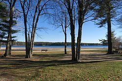
Island Pond (sometimes referred to locally as Big Island Pond) is a 532-acre (215 ha) water body located in Rockingham County in southern New Hampshire, in the towns of Derry, Hampstead and Atkinson. The pond is near the head of the Spicket River watershed, which feeds the Merrimack River in Lawrence, Massachusetts. The pond was formed from the merger of two smaller bodies of water in 1878, when a dam raised the water level by 8.5 feet.
Map of Island Pond, New Hampshire, USA
The pond is named for Governor's Island, a 200-acre (80 ha) island that lies within it. The island in turn is named for Benning Wentworth, colonial governor of New Hampshire, who built a summer residence on the north end of the island. A smaller island is named after the Native American chief Escumbuit.
The lake is classified as a cold- and warmwater fishery and contains largemouth and smallmouth bass, brook trout, rainbow trout, brown trout, chain pickerel, horned pout, white perch, black crappie, and bluegill.