
Existed: 1965 – present Constructed 1970 | Length 23.67 km | |
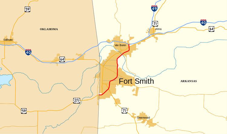 | ||
Interstate 540 (I-540) is a freeway spur route of I-40 in the US state of Arkansas in Fort Smith. The total length is 14.71 miles (23.67 km). At first, I-540 was a short spur connecting Fort Smith and Van Buren to I-40 as one of the original five Arkansas Interstates. The route ran just over 14 miles (23 km) to US 271 near the Oklahoma state line. The growing Northwest Arkansas area and the University of Arkansas needed an Interstate connection to Little Rock, and through traffic north to Kansas City had also outgrown the winding US 71 north from I-40. The route was extended north to Mountainburg in the late 1990s on an all-new alignment, (Going under concurrency with I-40, one of the only auxiliary routes with a concurrency with its parent) with the route being completed to Bella Vista in January 1999. However, the segment north of I-40 became a part of Interstate 49 in 2014.
Contents
Map of I-540, Arkansas, USA
Route description
The older portion of I-540, completed in the 1970s, connects Interstate 40 southwards to the Oklahoma state line, going through Van Buren and Fort Smith. This particular spur starts at Exit 7 on Interstate 40 (being seven miles (11 km) east of the state line with Oklahoma). That point marks mile zero on this spur, in keeping with Interstate Highway rules that spur mileage begins at the "parent" route. The first three miles (5 km) are through Van Buren, before the bridge over the Arkansas River. The remainder, for a grand total of approximately 15 miles (24 km), travels through Fort Smith. AHTD bid a $79 million project in 2013 for I-540 rehabilitation in Fort Smith that includes re-signing the route and renumbering the exits.
Fort Smith route
Beginning at the I-540 and I-40 junction in Van Buren, the route begins southward along the eastern boundary of Van Buren, with exits numbered sequentially heading south. The segment is largely concurrent with US 71. The first exit along this segment of I-540/US 71 is with US 64 and US 71B (US 71B), which leads west into the Van Buren Historic District and east to Alma. Continuing south, I-540/US 71 passes over Highway 162 (Kibler Rd), with no access between the routes. An exit providing access to Highway 59, via Riggs Dr (southbound) or Twin Cir Dr (northbound), is just prior crossing the Arkansas River. After crossing the river, the highways enter Fort Smith and Sebastian County. I-540/US 71 run through a commercial area and has three exits with city collector roads before an exit for Phoenix Ave, which gives access to Fort Smith Regional Airport. However, this exit does not have any access to southbound I-540/US 71.
Now turning toward the southwest, I-540/US 71 have exits with Highway 45 (Greenwood Rd) and Highway 255 (Zero St). Following these intersections, US 71 departs I-540 southbound toward Texarkana, with US 71B terminating at the parent route at the exit. I-540 begins to pass through a residential area before its final exit at US 271 and Highway 253. Following this exit, the roadway continues but ceases to be I-540, becoming US 271 and entering Oklahoma.
History
The Interstate spur opened in phases. According to a 1970 road map of Fort Smith, exits 2-11 (Van Buren through the Zero Street exit) were opened, with later exits (12-14) and the roadway itself still under construction. Portions of the roadway that became I-540 around Fayetteville were built in the early 1970s, but upgraded and extended in the mid-1990s. The highway around Fayetteville originally received US 71 signage until the complete I-540 spur was opened.
Originally, I-540 running from I-40 to Oklahoma through Fort Smith was originally signed east–west, but with the construction of the new spur that runs north through Northwest Arkansas to Missouri the entire I-540 was resigned as a north–south road. It is one of the few that have changed this way.
In the late 1990s, I-540 was extended into Northwest Arkansas. It had been planned since the 1970s as a bypass of U.S. Highway 71. The first section, between Alma and Mountainburg was known as Arkansas Highway 540. Originally, the Arkansas State Highway and Transportation Department (AHTD) asked the American Association of State Highway and Transportation Officials (AASHTO), who are in charge of Interstate and U.S. Highway route numbering, to allow the Interstate segment between Fort Smith and Bentonville to be named I-49, in order to emphasize plans to extend the route from Shreveport, Louisiana, through Arkansas to Kansas City, Missouri. AASHTO refused and the route opened on January 8, 1999, as a northern extension of I-540. On October 18, 2013, AASHTO approved AHTD's application to designate I-49 across the state, specifically allowing the state to renumber I-540 as I-49. The northern section of I-540 was renumbered I-49 in April 2014. This means that after I-49 is completed, the I-540 designation will be decommissioned.
Arkansas Highway 540
Highway 540 (AR 540, Ark. 540, and Hwy. 540) was a temporary designation for what would later become Interstate 540 between Alma and Mountainburg in the U.S. state of Arkansas. Traveling a distance of approximately 12 miles, its southern terminus was at I-40 west of Alma and its northern terminus at US 71 in Mountainburg.