
Country United States FIPS code 05-47300 Elevation 229 m Zip code 72946 Local time Monday 7:31 AM | Time zone Central (CST) (UTC-6) GNIS feature ID 0077771 Area 3.9 km² Population 624 (2013) Area code 479 | |
 | ||
Weather 15°C, Wind E at 5 km/h, 82% Humidity | ||
1955 mount gaylor lakeshore drive old retro signage and road mountainburg arkansas
Mountainburg is a city in Crawford County, Arkansas, United States. It is part of the Fort Smith, Arkansas-Oklahoma Metropolitan Statistical Area. As of the 2010 census the population was 631.
Contents
- 1955 mount gaylor lakeshore drive old retro signage and road mountainburg arkansas
- Map of Mountainburg AR 72946 USA
- Geography
- Demographics
- Notable people
- Climate
- References
Map of Mountainburg, AR 72946, USA
Geography
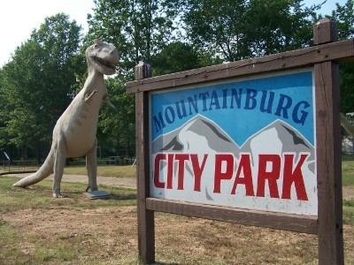
Mountainburg is located at 35°38′18″N 94°10′2″W (35.638432, -94.167219), along U.S. Route 71, and thrived when this road was the main route in northwest Arkansas. Since the construction of Interstate 540 (now Interstate 49) to the west, it has been a more sleepy community. The city park in downtown Mountainburg has since 1980 hosted two large dinosaur models.
Lake Fort Smith State Park, which is situated on the western side of the 1,400 acres (5.7 km2) Lake Fort Smith, is located 8 miles (13 km) north of Mountainburg.
According to the United States Census Bureau, the city has a total area of 1.5 square miles (3.9 km2), all land.
Demographics
As of the census of 2000, there were 682 people, 271 households, and 179 families residing in the city. The population density was 478.1 people per square mile (184.1/km²). There were 298 housing units at an average density of 208.9 per square mile (80.5/km²). The racial makeup of the city was 95.45% White, 0.15% Black or African American, 3.08% Native American, 0.15% Pacific Islander, 0.59% from other races, and 0.59% from two or more races. 0.59% of the population were Hispanic or Latino of any race.
There were 271 households out of which 35.8% had children under the age of 18 living with them, 52.0% were married couples living together, 10.7% had a female householder with no husband present, and 33.6% were non-families. 30.6% of all households were made up of individuals and 16.2% had someone living alone who was 65 years of age or older. The average household size was 2.52 and the average family size was 3.15.
In the city, the population was spread out with 29.2% under the age of 18, 8.2% from 18 to 24, 26.4% from 25 to 44, 20.8% from 45 to 64, and 15.4% who were 65 years of age or older. The median age was 34 years. For every 100 females there were 97.1 males. For every 100 females age 18 and over, there were 89.4 males.
The median income for a household in the city was $25,446, and the median income for a family was $33,295. Males had a median income of $24,375 versus $21,806 for females. The per capita income for the city was $14,445. About 12.0% of families and 17.3% of the population were below the poverty line, including 22.2% of those under age 18 and 20.1% of those age 65 or over.
Notable people
Climate
The climate in this area is characterized by hot, humid summers and generally mild to cool winters. According to the Köppen Climate Classification system, Mountainburg has a humid subtropical climate, abbreviated "Cfa" on climate maps.