
Length 15.76 km | ||
 | ||
North end: | ||
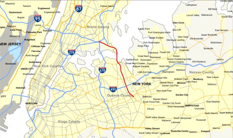
Interstate 295 (I-295) is a connector route within New York City. Measuring 9.10 miles (14.6 km) in length, I-295 travels from the Bruckner Interchange, a junction with I-95/I-278/I-678 in The Bronx, across the toll Throgs Neck Bridge to the Grand Central Parkway in Queens. Along the route, 295 meets with I-695 (Throgs Neck Expressway), the Cross Island Parkway, and I-495 (the Long Island Expressway). In Queens, I-295 is also known as the Clearview Expressway. The highway's southern terminus is a traffic signal at Hillside Avenue (New York State Route 25 or NY 25) in the Queens neighborhood of Queens Village. However, the original plan was to extend it further south to JFK Airport. The 0.8-mile (1.3 km) JFK Expressway was intended to be part of the Clearview, but was only constructed as far north as the Belt Parkway.
Contents
Map of I-295, New York, NY, USA
Route description
The existing section of the Clearview Expressway that carries the I-295 designation begins at the unfinished interchange with NY 25 where the ramps from northbound NY 24 (212th Street) and southbound Hollis Court Boulevard merge into the northbound and southbound lanes, respectively, of the highway. The Queens section of this roadway is known as "The 77th Infantry Division Expressway", honoring the U.S. Army's 77th Infantry Division of World War I and World War II fame; raised from draftees from New York City and Long Island, the 77th was also known as the Statue of Liberty Division, due to its shoulder-sleeve insignia. This Queens expressway instantly runs beneath a stack interchange with the Grand Central Parkway before immediately entering Cunningham Park. The Clearview leaves Cunningham Park at the interchange with Long Island Expressway, which used to be the eastern terminus of I-495 until the mid-1980s.
Shortly north of the I-495 interchange, the northbound off-ramp and southbound on-ramp at NY 25A split, then run under a pedestrian bridge that connects 46th Avenue. Other pedestrian bridges cross over the highway near 42nd Avenue and at 33rd Avenue. The northbound exit 5 uses 206th Street as a de facto service road, while 207th Street is used in the same way for the northbound on-ramps. Real service roads run beneath the Port Washington Branch of the Long Island Rail Road to connect NY 25A and 35th Avenue (exit 6A). The service roads merge into the expressway north of 26th Avenue (exit 6B).
The northbound partial interchange with Willets Point & Bell Boulevards leads to Cross Island Parkway, while a southbound interchange leads to the southbound Cross Island Parkway, all before reaching the Throgs Neck Bridge. The expressway then crosses the bridge.
After the Throgs Neck toll booth in the Bronx, I-295 becomes part of the Cross Bronx Expressway Extension. Just north of the toll booth, northbound access to Harding Avenue and Pennyfield Avenue is barely noticeable, as it is right next to the Y-interchange with I-695 (Throgs Neck Expressway), which takes motorists to northbound I-95. The only other interchange between there and the terminus is Randall Avenue.
I-295, running northwest, gains service roads for a mile until it finally ends at its parent route at the Bruckner Interchange, but only includes access to southbound I-95, and I-278.
History
The Clearview Expressway and Cross Bronx Expressway Extension were proposed in 1955 by the Port Authority and Triborough Bridge and Tunnel Authority (TBTA) as part of the Port Authority's Joint Study of Arterial Facilities, in order to to connect with the planned Throgs Neck Bridge. The Cross Bronx extension was planned to connect the bridge to several highways at the Bruckner Circle (now the Bruckner Interchange), while the Clearview was intended to connect with Horace Harding Boulevard (later the Long Island Expressway) in order to serve motorists from Long Island. Initially, the Clearview was intended to run along the existing right-of-ways of Utopia Parkway and Francis Lewis Boulevard. An alternate proposed routing would have ran along Little Neck Bay and through Alley Pond Park, essentially parallel to the Cross Island Parkway. By September 1956, the Clearview was mapped along 206th and 207th Streets and Hollis Court Boulevard, east of Francis Lewis Boulevard, after community opposition. The reroute reduced the amount of properties to be demolished or relocated from 860 to 421. An information center was set up by the TBTA for local residents displaced by the expressway.
The planning of the Clearview Expressway route by Robert Moses is documented in Robert Caro's biography of Moses, The Power Broker. A passage describes Moses and TBTA officials surveying potential routes for the highway in Queens, accidentally coming across protesters against the expressway.
Construction on the Clearview Expressway and Throgs Neck Bridge began in September 1957. As part of the project, land was taken from Clearview Park, the defunct Bayside Golf Course, and Cunningham Park. Meanwhile, hundreds of homes were physically relocated from the path of the expressway. Many of these houses were placed in planned communities built on the sites of the Bayside Golf Course, and the Oakland Country Club in Oakland Gardens. The Cross Bronx extension, the Throgs Neck Bridge, and the portion of the Clearview Expressway north of 73rd Avenue in Queens were opened on January 11, 1961. An extension of the Clearview south to Hillside Avenue (now NY 25) was opened to traffic on August 12, 1963. It was the first of several highways built to serve the 1964 New York World's Fair. Because of the steep hill at the end of the expressway leading to Hillside Avenue, the junction quickly became a frequent spot for accidents. This led to the implementation of a 40 mile-per-hour speed limit at the end of the highway, which remains in effect today. The modern Bruckner Interchange was opened on January 4, 1972.
The Cross Bronx Expressway Extension and the Clearview Expressway were originally designated as part of I-78, which was to continue south from Hillside Avenue through Southeast Queens, and west across Queens, Brooklyn, and Manhattan to the Holland Tunnel. Under these plans, the Clearview would have been extended south to NY 27 (Conduit Avenue) and the Belt Parkway, or to the Nassau Expressway and Rockaway Boulevard, in Laurelton near JFK Airport. Later plans had the Clearview ending farther east, intersecting with the Belt Parkway at its interchange with the Southern State Parkway. Ultimately, nearly all sections of I-78 between the Holland Tunnel and Hillside Avenue, including the Lower Manhattan Expressway, Bushwick Expressway, and the Clearview extension were cancelled by Governor Nelson Rockefeller in 1971. The only portion to be constructed was the short section of the Nassau Expressway near JFK Airport. This resulted in the renumbering of all of I-78 north of Hillside Avenue to I-295 on January 1, 1970.
In February 2003, the Clearview Expressway was renamed "The 77th Infantry Division Expressway".