
Existed: 1978 – present Length 4.94 km | Constructed 1978 | |
 | ||
West end: O'Hare International Airport in Chicago | ||
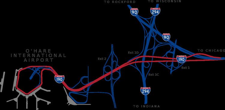
Interstate 190 (abbreviated I-190) is an intrastate Interstate Highway in the U.S. state of Illinois. I-190 runs west from I-90 to O'Hare International Airport. This is a distance of 3.07 miles (4.94 km). Interstate 190 is the westernmost leg of the Kennedy Expressway.
Contents
Map of I-190, Illinois, USA
Route description
Interstate 190 has two lanes in either direction between Interstate 90 and Interstate 294, and three lanes west of I-294. The freeway portion of I-190 consists largely of cloverleaf interchanges. The Blue Line operates in the median of I-190 for the highway's entire length.
Each road crossing I-190 is accessible via exit ramps. Not all interchanges are accessible in the same way from both directions, however. For example, the exit to southbound U.S. 12/45 traveling eastbound on I-190 requires exiting at Bessie Coleman Drive. Westbound, direct access is provided.
There is no specific sign indicating Interstate 190's western terminus at O'Hare. Interstate-standard freeway ends roughly at the ramps to the upper (Departure) and lower (Arrival) loops. The freeway then resumes shortly after both loops merge to cross an emergency fire lane.
The eastern terminus, I-90, is considered to be the origin point of the highway. Both exit numbers and mileage markers on roadside light fixtures ascend traveling westbound.
History
The highway that is now I-190 was signed as part of Illinois Route 194 from 1960 to 1970. In 1971, it was changed to Illinois Route 594. and was changed to I-190 around 1978 after the rest of Illinois 194 was changed to Interstate 90 in the mid to late 1970s.
O'Hare Airport originally opened in 1942, and was expanded to its current size in 1962.
In late 2005, the intersection with Mannheim Road was reconstructed to remove unsafe conditions and bring the route closer to Interstate standards. In the late 1990s, the Illinois Department of Transportation restriped I-190 at Interstate 294. This action increased the number of lanes west of I-294 from two to three. In the process, the speed limit was reduced from 45 to 35, and yield signs were erected at the ends of the ramp from northbound Mannheim Road to westbound I-190, the busiest ramp at that intersection. This created a hazardous condition, often leading to high-speed crashes should drivers waiting on the ramp become impatient or underestimate the speed of westbound traffic. Often, an IDOT Minuteman (rapid response vehicle) would be stationed on the ramp waiting to tow away vehicles that would be involved in a crash during rush hour.
The improvements are designed to widen bridges and create significantly more merging space so that collision hazards are mitigated. In addition, the Mannheim Road bridge over Interstate 190 had outlived its useful life.
Exit list
Although exit numbers on I-190 increase from east to west, this table presents interchanges from west to east to follow IDOT milepost measurements starting at O'Hare International Airport.
The entire route is in Cook County.