Ingavi is a province in the La Paz Department in Bolivia. This is where the Battle of Ingavi occurred on November 18, 1841 and where the World Heritage Site of Tiwanaku is situated.
During the presidency of Eliodoro Villazón the province was founded on December 16, 1909 with Viacha as its capital.
Ingavi lies on the southern shore of Lake Titicaca. The Chilla-Kimsa Chata mountain range traverses the province. Some of the highest mountains of the province are listed below:
Ingavi Province is divided into seven municipalities which are partly further subdivided into cantons.
The people are predominantly indigenous citizens of Aymara descent.
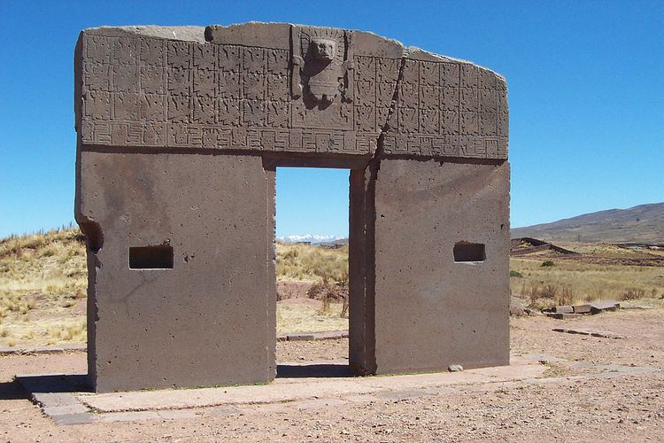
Some of the tourist attractions of the municipalities are:
In Viacha Municipality:The town of ViachaViriloco lagoon, a small man made lake in Viacha CantonQalachaka bridge in Viacha Canton"Virgen de Letanías" Sanctuary in Viacha Canton"Pan de Azúcar" mountain in Viacha CantonFields of the Battle of Ingavi in Viacha CantonIn Guaqui Municipality:Guaqui festivity from July 23 to July 25 celebrated in honour of Apostle JamesApostle James church of Guaqui built between 1625 and 1784Guaqui portIn Tiwanaku Municipality:archaeological site of Tiwanaku in Tiwanaku CantonSaint Peter church in TiwanakuWillkakuti, the Andean-Amazonic New Year, celebrated on June 21 of every year in the viewpoint of Kimsa Chata mountain in Tiwanaku CantonTiwanaku festivity (Señor de la Exaltación) celebrated in Tiwanaku Canton in SeptemberIn Desaguadero Municipality:The international fair of Desaguadero on the Peruvian borderDesaguadero River with its avifauna and native Aymara and Uru communities along its banks. The river runs along the entire Altiplano.In San Andrés de Machaca Municipality:Afiani lagoon in San Andrés de Machaca CantonThe chullpa of Kañoma in San Andrés de Machaca CantonThe church of San Andrés de Machaca, built between 1806 and 1836In Jesús de Machaca Municipality:The archaeological site of Qhunqhu Wankani in Jesús de Machaca CantonJesús de Machaca, an indigenous communityYakayuni saltflats in Jesús de Machaca Canton where salt exploitation is possibleUru Iruwit'u community in Jesús de Machaca Canton and the Uru Iruwit'u museum in Jesús de MachacaIn Taraco Municipality:Taraco Peninsula in Taraco Canton with its archaeological sites:Chiripa and its museumQala Uyuni, Pumani and Achacachi Coacollo in CoacolloIwawi (Kolata Quenacache, Ojje Puku, Awichu and Ch'uxña Qala) in Higuagui Grande, Taraco CantonSikuya Island in Taraco CantonThe church of Taraco dating from 1767Taraco museum in Taraco Canton