
Existed: 1931 – present Length 154.8 km | Constructed 1931 | |
 | ||
Major cities | ||
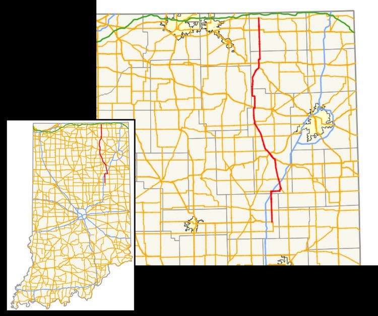
State Road 5 (SR 5) is a north–south road that runs through northeast Indiana. Its southern terminus is at SR 22 in Upland, and the northern terminus is at SR 120 just north of Shipshewana. The largest city along its path is Huntington. It is entirely a surface highway that is very rural outside of the towns.
Contents
Map of IN-5, Indiana, USA
Route description
SR 5's southern terminus is at SR 22, where SR 5 heads north toward Huntington. SR 5 passes through an intersection with State Road 18 and then through the town of Van Buren. SR 5 passes over Interstate 69 (I-69) and then has a concurrency with State Road 218. SR 5 and SR 218 travel east to Warren. Soon after the concurrency begins, SR 5 and SR 218 have an interchange with I-69. In Warren SR 218 turns southeast and SR 5 turns northwest. North of Warren SR 5 has another interchange with I-69. SR 5 heads toward Huntington, passing through intersection with State Road 124. In southeast Huntington SR 5 and U.S. Route 224 (US 224) have a concurrency. In Huntington US 224/SR 5 are on one-way streets with west US 224/north SR 5 on Warren Street and east US 224/south SR 5 on Cherry Street. US 224 and SR 5 heads northwest out of Huntington, then US 224 and SR 5 have an intersection with U.S. Route 24/State Road 9. This intersection is the western terminus of US 224.
SR 5 heads northwest, just outside Huntington SR 5 has an intersection with the eastern terminus of State Road 16. SR 5 heads north until South Whitley. In South Whitley SR 5 has a concurrency with State Road 14 and an intersection with the southern terminus of State Road 205. SR 5 heads north out of South Whitley towards Larwill. In Larwill SR 5 has an intersection with U.S. Route 30. SR 5 heads north from Larwill towards Liigonier, passing through Indian Village and Cromwell. South of Ligonier, SR 5 and US 33 have a concurrency that ends at US 6. From US 6, SR 5 heads north, passing through the downtown area of Ligonier. The road then leaves the downtown of Ligonier heading north, passing over the Elkhart River on a bridge and then under the Norfolk Southern Railway tracks. The route makes a sharp curve heading due east, before curving due north once again. The highway heads north until Shipshewana where SR 5 has an intersection with US 20, before heading into downtown Shipshewana. North of Shipshewana, SR 5 heads due north toward Michigan. The northern terminus of SR 5 is at SR 120.
History
Between 1917 and 1920 SR 5 had a route that went from Vincennes to Mitchell. Following the today's route of U.S. Route 150, U.S. Route 50, and State Road 60. Then between 1920 and 1926 SR 5 went from Vincennes to New Albany following the today's route of US 150.
Then the route was changed to the current route of SR 5 from Warren to SR 120. In 1985 SR 5 was route to Upland on the Old State Road 221. The north terminus was at the Michigan State Line at one point, passing through Scott.