
Phone number 0269-62-3111 Population 20,989 (Oct 2016) Local time Saturday 3:00 AM | Area 202.4 km² | |
 | ||
Website www.city.iiyama.nagano.jp Weather 0°C, Wind NW at 11 km/h, 91% Humidity Points of interest Madarao Kogen ski resort, Madaraokogen Hot Spring, Mt Madarao, Nanohana Park, Shinshuji | ||
Explore japan s countryside in iiyama nagano ft iiyama nanohana park etc
Iiyama (飯山市, Iiyama-shi) is a city located in northern Nagano Prefecture, in the Chūbu region of Japan. As of 1 October 2016, the city had an estimated population of 20,989 and a population density of 104 persons per km². Its total area was 202.43 square kilometres (78.16 sq mi). It markets itself as "Japan's Hometown" and is known as the "little Kyoto of Snow Country".
Contents
- Explore japan s countryside in iiyama nagano ft iiyama nanohana park etc
- Map of Iiyama Nagano Prefecture Japan
- Geography
- Surrounding municipalities
- Economy
- History
- Education
- Railway
- Highway
- International relations
- Local attractions
- Noted people from Iiyama
- References
Map of Iiyama, Nagano Prefecture, Japan
Geography
Iiyama is located in the mountainous far northern portion of Nagano Prefecture, and is bordered by Niigata Prefecture to the north. The area is known for severe winters with heavy snowfall. The Chikuma River (the longest river in Japan) runs through the centre of the area and becomes known as the Shinano River when it passes into Niigata Prefecture.
Surrounding municipalities
Economy
The economy of Iiyama is primarily agricultural, with seasonal tourism to its ski resorts and hot springs making a major contribution.
The TV and electronics manufacturer Iiyama was founded in the city in 1972, although, after a series of mergers, the company is no longer headquartered there. The old office continues to be used as a manufacturing centre for Iiyama's parent company, Mouse Computer.
History
The area of present-day Iiyama was part of ancient Shinano Province. The area was part of the holdings of Iiyama Domain during the Edo period. The modern town of Iiyama was established within Shimominochi District, Nagano with the establishment of the municipalities system on April 1, 1889. It was raised to city status on August 1, 1954 by the merger of the town of Iiyama with neighboring villages of Akitsu, Tokiwa, Yanagihara, Tozama, Kijima and Zuiho. The villages of Ōta and Okayama were also annexed in 1955.
Education
Iiyama has seven public elementary schools and two public middle schools. There is one public high school operated by the Nagano Prefectural Board of Education.
Railway
Highway
International relations
Local attractions
There are many well known ski resorts in the area. These include Nozawa Onsen Snow Resort, Madarao Sympathique, Madarao Kogen, Tangram Ski Circus, Togari Onsen, and Hokuryuko
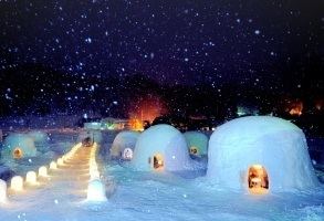
Iiyama also hosts a number of popular festivals such as the Iiyama Snow Festival and Kamakura Snow Hut Festival in February and Iiyama Dontokoi in August.
The Shinestsu Trail, that runs through Iiyama along the border between Nagano prefecture and Niigata prefecture, is a popular hiking spot in summer.
In February 2015, Guinness World Records confirmed that the city had officially broken the record for 'most snowmen built in an hour.'