
Length 55 km | ||
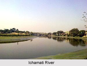 | ||
Best tourist place in kolkata ichamati river taki beside bangladesh border side screen
Ichamati River (Bengali: ইছামতি নদী)(also spelt Ichhamati), is a trans-boundary river which flows through India and Bangladesh and also forms the boundary between the two countries. The river is facing the problem of siltation leading to thin flow of water in the dry season and floods in the rainy season. Experts are handling the situation and remedial matters are being discussed between the governments of India and Bangladesh.
Contents
- Best tourist place in kolkata ichamati river taki beside bangladesh border side screen
- Map of ICHAMATI RIVER
- Visit to ichamati river in taki west bengal part 4
- Ichamati flow
- Lower Ichamati
- River bed raised
- Immersion of Durga images
- References
Map of ICHAMATI RIVER
Visit to ichamati river in taki west bengal part 4
Ichamati flow
Ichamati River is now in three parts: (1) The longer part flows from the Mathabhanga River, a distributary of the Padma, and after flowing for 208 kilometres (129 mi) joins the Kalindi River near Hasnabad in North 24 Parganas and Debhata in Satkhira District. (2) Once the main river west of Dhaka and (3) Ichamati of Dinajpur. Rennel’s map of 1764–66, shows the last two rivers as one. According to a number of hydrologists, the three Ichamati rivers, in the past, were a single channel. The second river marked above originates south of Jafarganj opposite to the mouth of the Hoorsagar near Nathpur factory and runs towards Joginighat in Munshiganj. Joginighat is situated at the confluence of the Jamuna and the Ichamati. There are five pilgrimage ghats along the river locally known as Panchatirtha ghats—Tirthaghat, Agla, Solepur, Barunighat and Joginighat.
Lower Ichamati
The Mathabhanga River originates from the rightbank of the Padma, at Munshiganj in Kushtia District in Bangladesh. It bifurcates near Majidia in Nadia District in India, creating two rivers, Ichamati and Churni. After traversing a length of 19.5 kilometres (12.1 mi) in India, the Ichamati enters Bangladesh near Mubarakpur. It flows for 35.5 kilometres (22.1 mi) in Bangladesh and again enters India at Duttaphulia in Nadia district. It forms the international border between India and Bangladesh for 21 kilometres (13 mi) from Angrail to Kalanchi, and again from Goalpara to the Kalindi-Raimangal outfall into the Bay of Bengal.
The Bhairab once flowed from the Ganges, across the present beds of the Jalangi, and further eastwards towards Faridpur. The Bhairab is no more a very active river. The Mathabhanga is a younger stream than Jalangi and it was not till very recently that the river completed its junction with the Hooghly by adopting the River Churni (now its lower reaches) for its main course. Earlier most of the water of the Mathabhanga ran off to the east down the Kumara, Chitra, Coboduk (Bhairab), and Ichamati, but all these escape routes have been shut off, except a small amount for the Ichamati. The point to note is that while earlier the rivers in the region flowed in a south-easterly direction, but later some force pulled the Jalangi and the Mathabhanga in a south-westerly direction. The inference is that it occurred because of a local subsidence, which was active for some period prior to 1750 and which has since become inactive.
River bed raised
While the bed of the Ichamati river is 4.3 metres (14 ft) higher than that of the Mathabhanga, that of the Churni is lower than Mathabhanga by 15 centimetres (6 in). During the lean period the level of water in the Mathabhanga is higher than that of the Padma. As a result, no water enters the Ichamati during the dry season. One of the causes of silting of the river was construction of guard wall for railway over bridge. The river beds in the area need to be excavated in order that there is flow of water during the lean season. Since this is required to be done both in India and Bangladesh, there is need for accord on this point. The matter has been discussed at the ministerial level, the area surveyed to have better idea of the problems of the people in the affected area, and decisive action is expected in the near future.
The river zone also faces the problem of industrial pollution and forcible occupation of land by people. Arresting environmental hazards resulting from lack of sanitation facilities, encroachment, groundwater contamination like arsenic pollution, destruction of aquatic flora, fauna are some of the burning problem of the areas that needs to be tackled through participatory mechanism.
Ichhamati river and its branches form a large oxbow lake complex near Bangaon in North 24-Paraganas district. Besides agricultural and anthropogenic stresses, weed infestation particularly with water hyacinth (Eichhornia crassipes) is a major concern because it is covering the surface of lake waters.
Immersion of Durga images
At the end of Durga Puja the immersion ceremony in the Ichamati offers a unique spectacle along the India-Bangladesh river border. The Ichhamati river, which acts as a natural border between the two countries, becomes the scene of tremendous revelry on this day, when boats crammed with people from both countries converge here to immerse their respective idols. Boats of all shapes and sizes can be seen on the river, as far as the eye can see — each one flying the flag of its respective country. It is the only day during the year when border patrolling is relaxed and people can cross over to the other side of the river. While earlier, after immersing their idols, people could even disembark from their boats on the other side, restrictions imposed by border officials in the last few years has put an end to this practice.