
Mission duration 3 years Launch mass 1,324 kg Cost 96.6 million USD (2013) | Power 1200 watts Inclination 92° Launch date 2018 | |
 | ||
Similar ICESat, Soil Moisture Active Pa, Solar Radiation and Clim, Orbiting Carbon Observatory, ACRIMSAT | ||
Launchpad icesat 2 next generation technology
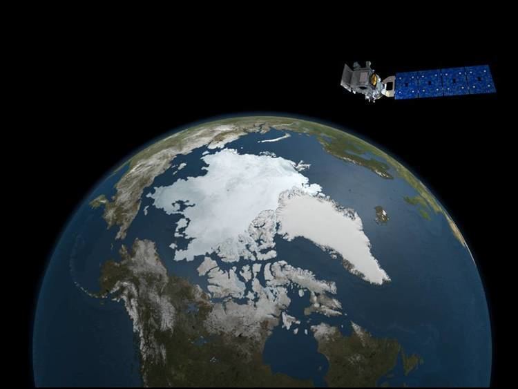
ICESat-2 (Ice, Cloud, and land Elevation Satellite 2), part of NASA's Earth Observing System, is a planned satellite mission for measuring ice sheet elevation, sea ice freeboard as well as land topography and vegetation characteristics. ICESat-2 is a planned follow-on to the ICESat mission. It will be launched in 2018 from Vandenberg Air Force Base in California into a near-circular, near-polar orbit with an altitude of approximately 496 km. It is being designed to operate for 3 years, and will carry enough propellant for 7 years.
Contents
- Launchpad icesat 2 next generation technology
- Satellite Instruments
- Mission Science
- Applications
- Education and Public Outreach
- References
The ICESat-2 mission is designed to provide elevation data needed to determine ice sheet mass balance as well as vegetation canopy information. It will provide topography measurements of cities, lakes and reservoirs, oceans and land surfaces around the globe, in addition to the polar-specific coverage.
The ICESat-2 project is being managed by NASA Goddard Space Flight Center. The sole instrument is being designed and built by NASA Goddard Space Flight Center, and the bus is being provided by Orbital ATK. The satellite will launch on a Delta II rocket provided by United Launch Alliance.
Satellite Instruments
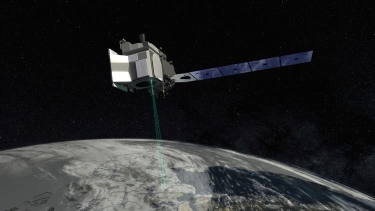
The sole instrument on ICESat-2 will be the Advanced Topographic Laser Altimeter System (ATLAS), a space-based LIDAR. ATLAS will time the flight of laser photons from the satellite to Earth and back; computer programs will use the travel time from multiple pulses to determine elevation.
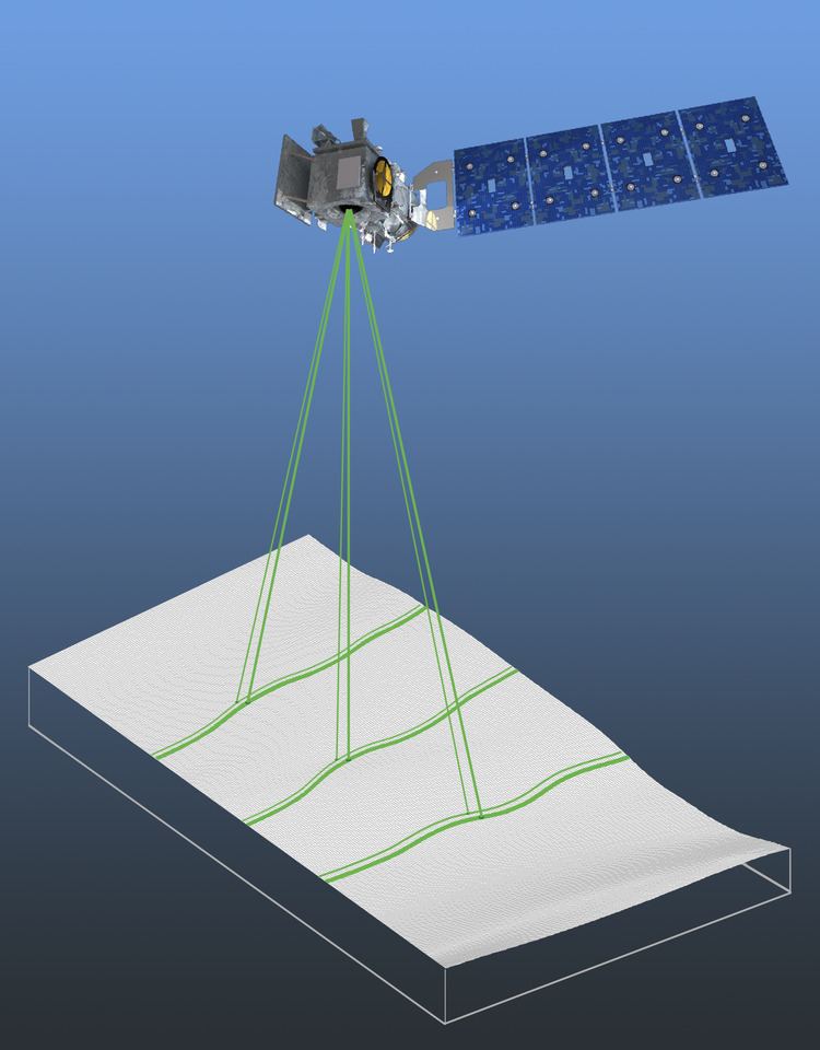
The ATLAS laser will emit visible laser pulses at 532 nm wavelength. The laser is being developed and built by Fibertek, Inc. As ICESat-2 orbits, the ATLAS will generate six beams arranged in three pairs, with the pairs 3.3 km apart, in order to better determine the surface’s slope and provide more ground coverage. ATLAS will take elevation measurements every 70 cm along the satellite’s ground path.
The laser will fire at a rate of 10 kHz. Each pulse sends out about 20 trillion photons, almost all of which are dispersed or deflected as the pulse travels to Earth’s surface and bounces back to the satellite. About a dozen photons from each pulse return to the instrument and are collected in a beryllium telescope.
The National Snow and Ice Data Center Distributed Active Archive Center will manage ICESat-2 science data.
Mission Science
ICESat-2 has four science objectives:
- Quantify polar ice-sheet contributions to current and recent sea-level change and the linkages to climate conditions;
- Quantify regional signatures of ice-sheet changes to assess mechanisms driving those change and improve predictive ice sheet models; this includes quantifying the regional evolution of ice sheet change, such as how changes at outlet glacier termini propagate inward;
- Estimate sea-ice thickness to examine ice/ocean/atmosphere exchanges of energy, mass and moisture;
- Measure vegetation canopy height as a basis for estimating large-scale biomass and biomass change.
In addition, ICESat-2 will take measurements of the height of oceans, inland water bodies like reservoirs and lakes, cities, and ground movements after events like earthquakes or landslides.
NASA's airborne mission Operation IceBridge is collecting data to bridge the gap between ICESat and ICESat-2.
Applications
ICESat-2’s Applications program is designed to engage people and organizations who plan to use the data, before the satellite launches. Early Adopters in the program, including ice scientists, ecologists, and the Navy, will work with the ICESat-2 applications team to provide information on how the satellite observations can be used.
Education and Public Outreach
The ICESat-2 Education and Public Outreach (EPO) Project Implementation Plan (PIP) is currently being developed during Phase B of the ICESat-2 Mission. The development of the ICESat-2 EPO PIP is guided by the following:
Overarching Objective: To educate students, educators, and the public on the scientific attributes and societal benefits of the ICESat-2 Mission.
Goals:
- To promote the future of the ICESat-2 mission as an integral part of NASA's Earth-observing fleet of satellites
- To develop and sustain mission education and outreach activities through leveraging of historically-successful national and international education programs
- To have ICESat-2 education become part of a wider multi-mission education effort in the Earth Sciences
- To promote ICESat-2 as being one of the leading satellites promoting and fostering an understanding of global climate change
ICESat-2 is on social media at https://www.facebook.com/ICESat2/ and https://twitter.com/NASA_ICESat2