
 | ||
Area 14,651 km (5,657 sq mi) Established 1928 as a Game Reserve (1961 as a National Park) Governing body Zimbabwe Parks and Wildlife Management Authority | ||
Hwange National Park (formerly Wankie Game Reserve) is the largest game reserve in Zimbabwe. The park lies in the west, on the main road between Bulawayo and the widely noted Victoria Falls and near to Dete.
Contents
- History of the park
- Poaching incidents
- Cecil Poaching Incident
- Flora
- Fauna
- Geography and geology
- Archaeological historical and cultural sites
- Main Camp area
- Sinamatella area
- Robins Camp area
- Linkwasha concession area
- Dzivanini wilderness area
- Shakwanki wilderness area
- Tsamhole wilderness area
- Accommodation and camping
- Main camp
- Sinamatella camp
- Robins camp
- Nantwich camp
- Bumbusi exclusive camp
- Lukosi exclusive camp
- Deka exclusive camp
- Bush camps
- Camping and picnic sites
- Privately operated camps and sites
- Proposed camps
- References
History of the park
It was founded in 1928, with the first warden being by the 22-year-old Ted Davison. He befriended the Manchester-born James Jones who was the stationmaster for the then Rhodesian Railways at Dete which is very near Hwange Main Camp. Jones managed incoming supplies for the park.
This park is considered for inclusion in the 5 Nation Kavango - Zambezi Transfrontier Conservation Area.
Poaching incidents
In 2011, nine elephants, five lions and two buffalos were also killed by poachers.
In October 2013 it was discovered that poachers killed a large number of African elephants with cyanide after poisoning their waterhole. Conservationists have claimed the incident to be the highest massacre of animals in Southern Africa in 25 years. Two aerial surveys were carried to determine the extent of the deaths, and 19 carcasses were identified in the first survey and a further 84 carcasses in the second survey. Three of the poachers were caught, arrested, tried, convicted and sentenced. All royal game and elephant poaching offences now have a mandatory 9-year sentence and the supply chain is also targeted – with a man arrested on 21 October trying to smuggle raw ivory out.
Cecil Poaching Incident
On or about July 1, 2015, Cecil, a lion who had lived on Hwange National Park for 13 years, was illegally killed. This action spurred widespread social media coverage and a petition calling for Zimbabwe's president Robert Mugabe to outlaw big game hunting permits. Dr. Walter Palmer, the admitted killer of Cecil, had a permit and was not charged with any crime, as all his papers were in order. Authorities in Zimbabwe have said he is free to visit the country. The complicity of corrupt Zimbabwean officials with poachers is claimed. But, Theo Bronkhorst, the unlicensed guide in charge of the Cecil killing is presently on bail awaiting several trials. One trial for the killing of Cecil, where he is charged with “failing to prevent an illegal hunt,” and at least one other trial for other wildlife crimes.
Flora
The park is close to the edge of the Kalahari desert, a region with little water and very sparse, xerophile vegetation. The Kalahari woodland is dominated by Zambezi Teak, Sand Camwood (Baphia) and Kalahari bauhinia. Seasonal wetlands form grasslands in this area.
The north and north-west of the park are dominated by mopane woodland.
Although it has been argued that elephant populations cause change in vegetation structure, some recent studies suggest that this is not the case, even with the large increases in elephant population recorded in the late 1980s.
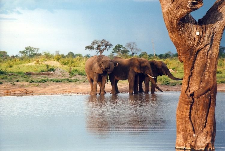
Fauna
The Park hosts over 100 mammal and 400 bird species, including 19 large herbivores and eight large carnivores. All Zimbabwe's specially protected animals are to be found in Hwange and it is the only protected area where gemsbok and brown hyena occur in reasonable numbers.
Grazing herbivores are more common in the Main Camp Wild Area and Linkwasha Concession Area, with mixed feeders more common in the Robins and Sinamatella Wild Areas, which are more heavily wooded. Distribution fluctuates seasonally, with large herbivores concentrating in areas where intensive water pumping is maintained during the dry season.
The population of the Cape wild dogs to be found in Hwange is thought to be of one of the larger surviving groups in Africa today, along with that of Kruger National Park and Selous Game Reserve. Other major predators include the Southwest African lion, whose distribution and hunting in Hwange is strongly related to the pans and waterholes, African leopard, spotted hyena and South African cheetah.
Elephants have been enormously successful in Hwange and the population has increased to far above that naturally supported by such an area. This population of elephants has put a lot of strain on the resources of the park. There has been a lot of debate on how to deal with this, with parks authorities implementing culling to reduce populations, especially during 1967 to 1986. The elephant population doubled in the five years following the end of culling in 1986.
National Parks Scientific Services co-ordinates two major conservation and research projects in the park:
Geography and geology
Most of the park is underlain by Kalahari Sands. In the north-west there are basalt lava flows of the Batoka Formation, stretching from south of Bumbusi to the Botswana border. In the north-central area, from Sinamatella going eastwards, there are granites and gneisses of the Kamativi-Dete Inlier and smaller inliers of these rocks are found within the basalts in the north-west.
The north and north-west of the park are drained by the Deka and Lukosi rivers and their tributaries, and the far south of the park is drained by the Gwabadzabuya River, a tributary of the Nata River. There are no rivers in the rest of the park, although there are fossil drainage channels in the main camp and Linkwasha areas, which form seasonal wetlands. In these areas without rivers, grassy pan depressions and pans have formed. Some of these pans, such as many of the pans in the Shumba area, fill with rainwater, while others, such as Ngweshla, Shakwanki and Nehimba, are fed by natural groundwater seeps. Many of the pans are additionally supplied by water pumped from underground by park authorities.
Archaeological, historical and cultural sites
The Bumbusi National Monument, comprising ruins and rock carvings, is located on the northern edge of the park. There are also ruins at Mtoa and rock carvings at Deteema.
Main Camp area
Sinamatella area
Robins Camp area
Linkwasha concession area
Dzivanini wilderness area
Shakwanki wilderness area
Tsamhole wilderness area
Accommodation and camping
The park has three large rest camps and four smaller permanent camps.
Main camp
This is the park headquarters, in the north-east, easily accessible by tarred road from the main Bulawayo–Victoria Falls road. There are a variety of self-catering accommodation, camping and caravan sites, a bar and restaurant and a supermarket.
Sinamatella camp
Sinamatella is in the north, several hours' drive through the park from Main Camp, or a shorter journey on a dirt road from the main Bulawayo–Victoria Falls road. Set on an escarpment above a waterhole, overlooking miles of bush. The camps has similar accommodation and camping facilities to Main Camp and a kiosk.
Robins camp
Robins is in the north-west, and has self-catering accommodation and camping sites but no other facilities. The camp is based around the old clock tower of the farm of Harold Robins, donated to the park in 1939.
Nantwich camp
Nantwich is located near Robins Camp, and has three self-catering lodges, built on a bluff overlooking a pan. The lodges were not functional, and in a serious state of decay, in August 2013.
Bumbusi exclusive camp
Bumbusi is an exclusive camp for one party at a time, comprising self-catering accommodation for up to twelve persons. It is located twelve kilometres north-west of Sinamatella, near the Deka River and the Bumbusi National Monument.
Lukosi exclusive camp
This is an exclusive camp for one party at a time, comprising self-catering accommodation for up to ten persons. It is located ten kilometres east of Sinamatella, near the Lukosi River and is only open in the rainy season.
Deka exclusive camp
This is an exclusive camp for one party at a time, comprising self-catering accommodation for up to twelve persons. It is located twenty-five kilometres west of Robins, in headwaters of the Deka River and requires four-wheel drive for access.
Bush camps
These are remote camping sites with no facilities, for one party at a time. The bush camps are:
Camping and picnic sites
In addition, overnight camping is permitted at picnic sites and some of the platforms overlooking waterholes; bookings must be made in advance with the National Parks board. Camping is restricted to one party at a time and during the day, the facilities are open to all visitors. The sites are:
Privately operated camps and sites
There are a number of privately operated tented camps within the park:
Proposed camps
Long-term planning provides for the establishment of four further rest camps: