
Formed August 28, 2003 Fatalities None Highest winds 169 km/h | Dissipated September 5, 2003 | |
 | ||
Lowest pressure 970 mbar (hPa); 28.64 inHg Date 28 August 2003 – 5 September 2003 Similar Hurricane Ignacio, Tropical Storm Ignacio, Hurricane Olaf, Hurricane Fred, Tropical Storm Olaf | ||
Hurricane Jimena was the tenth named storm and second hurricane of the 2003 Pacific hurricane season. Jimena formed on August 28 in the far Eastern Pacific Ocean as a tropical depression and moved westward where it rapidly became a hurricane the following day. The storm moved westward into the Central Pacific Ocean where it became a Category 2 hurricane on the Saffir–Simpson Hurricane Scale. After reaching its peak strength as a Category 2 hurricane, the storm began to weaken due to increasing wind shear. Jimena brushed past the Hawaiian Islands before becoming a tropical depression on September 3. The weakening storm then crossed the international dateline before dissipating on September 5, becoming one of the few storms to cross both 140ºW and International Date Line.
Contents
Jimena was the first Pacific hurricane to threaten Hawaii since Hurricane Daniel of the 2000 Pacific hurricane season. However, the storm weakened as it passed south of the islands and the effects from Jimena were minimal; there were no reported fatalities or injuries from the storm.
Meteorological history
An area of disturbed weather formed on August 26, 2003 and drifted westward. The disturbed weather then began to organize and the system became a tropical depression on August 28. Moving westward over waters greater than 82 °F (28 °C), Tropical Depression Ten-E rapidly strengthened into a tropical storm and was named Jimena by the National Hurricane Center.
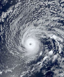
Jimena continued to intensify as it moved westward. On August 29, satellite imagery showed a well defined eye developing in the storm as the storm winds increased to 60 mph (97 km/h). Jimena then was upgraded to hurricane status later that day. At 1500 UTC, visible satellite imagery showed the storm having a small cloud filled eye and developing banding features south of the storm's center as Jimena continued to move west northwest. As the hurricane neared the Central Pacific Basin, it winds reached a peak intensity of 105 mph (165 km/h) and the barometric pressure fell to 970 millibars on August 30. At 0600 UTC, the National Hurricane Center issued its last advisory on Jimena as the storm crossed into the Central Pacific Hurricane Center's area of responsibility.
On August 31, Jimena encountered strong southerly wind shear, causing it to quickly weaken back to a tropical storm by September 1. Jimena then turned west-southwest where the center of the storm passed 105 miles (165 km) south of Hawaii at 1500 UTC. Jimena continued to weaken as wind shear increased and the storm weakened to a tropical depression on September 3. After weakening back to a depression, Jimena crossed the International Date Line on September 5 at 0600 UTC, where it became the first storm to exist in all three Pacific basins since 1999's Hurricane Dora. However, Jimena was only tracked briefly by the Joint Typhoon Warning Center, since strong wind shear resulted in the low level circulation to be exposed from the center and at 1727 UTC, the low level had nearly dissipated. At 1800 UTC, the Joint Typhoon Warning Center issued their final advisory on Jimena as the storm dissipated 715 miles (1151 km) southeast of Wake Island.
Preparations and impact
Forecasters at the Central Pacific Hurricane Center began issuing a Hurricane Watch for the Big Island of Hawaii on August 31 at 0000 UTC; the following day the Central Pacific Hurricane Center (CPHC) issued a tropical storm warning at 0300 UTC and a flash flood watch. The watches and warnings prompted residents to board up windows and stock up on emergency supplies. The storm's approach also closed down beaches and prompted officials to cancel outdoor activates as a precaution and the American Red Cross opened shelters and provided emergency services. The preparations for Hurricane Jimena cost the American Red Cross $5,000 (2003 USD).
As Jimena passed south of Hawaii as a weakening tropical storm, it brought high winds and heavy rainfall to the island. High wind gusts of 53–58 mph (85–93 km/h) were reported in South Point and Kahoolawe. In Honolulu, a weather station reported winds of 36 mph (58 km/h) while a station in Kauai reported winds of 22 mph (35 km/h). The storm dropped 6–10 inches of rain across the Big Island. In Glenwood, Hawaii, the storm dropped 8.43 inches (214 mm) of rain. The rainfall from Jimena helped reduce drought conditions across the Big Island. Coastal sections of the Hawaiian Islands reported high surf ranging from 11 to 15 feet (3–5 meters) high.
High winds from Jimena knocked down trees and damaged power lines, leaving 1,300 residents without electricity. Heavy rainfall from the storm also caused minor flooding on the eastern side of the Big Island. Offshore, high surf and strong currents brought by the storm resulted in 350 swimmers being rescued by the United States Coast Guard, residents, and state and local police and fire departments. Overall there were no fatalities or injuries from Hurricane Jimena. The name Jimena was not retired by the World Meteorological Organization in the spring of 2004 and was used in the 2009 season.