
Time zone PST (UTC+5) | ||
 | ||
The Hunza (Burushaski and Urdu: ہنزہ) is a mountainous valley in the Gilgit–Baltistan region of Pakistan. The Hunza is situated in the extreme northern part of Pakistan.
Contents
- Map of Hunza Valley Garelt
- History
- MirTham
- 2010 landslide
- Capital of Hunza
- Geography
- Gojal Valley
- Lower Hunza
- Central Hunza
- Climate
- Transport
- Scenery
- People of Hunza
- References
Map of Hunza Valley, Garelt
History
Hunza was formerly a princely state bordering Uyghurstan also called Xinjiang (autonomous region of China) to the northeast and Pamir to the northwest, which survived until 1974, when it was finally dissolved by Zulfikar Ali Bhutto. The state bordered the Gilgit Agency to the south and the former princely state of Nagar to the east. The state capital was the town of Baltit (also known as Karimabad); another old settlement is Ganish Village. Hunza was an independent principality for more than 900 years. The British gained control of Hunza and the neighbouring valley of Nagar between 1889 and 1892 through a military conquest. The then Mir/Tham (ruler) Mir Safdar Ali Khan of Hunza fled to Kashghar in China and sought what would now be called political asylum.
Mir/Tham
An account wrote by John Bidulf in his book 'Tribes of Hindukush'
The traditional name for the ruler or Prince in Hunza was Tham (also Thom or Thum), which is also a respectful greeting used by the people of both Hunza and Nager who belong to the clan of Boorish. The Shin use the term Yeshkun for the Boorish.
2010 landslide
In 2010, a landslide blocked the river and created Attabad Lake, which threatened 15,000 people in the valley below and has effectively blocked 27 km of the Karakoram Highway.
Capital of Hunza
The first seat of power of the formerly Hunza State was Altit. Later it shifted to Baltit (modern-day Karimabad). Until the fall of princely state in 1974, Baltit served as political center of Hunza and hence its capital. Today, Baltit is one of the major tourist destinations in Hunza. The center of activities has however shifted to the nearby Aliabad, which is a commercial hub in the region and has most of the governmental infrastructure.
Geography
Hunza is divided into 3 geographic subdivisions:
Gojal Valley
Gojal === Gojal === of Hunza District. The main towns, villages and valleys are:
Lower Hunza
Lower Hunza comprises the parts of Aliabad tehsil of Hunza District. The main towns, villages and valleys are:
Central Hunza
Central Hunza consists of the parts of Aliabad tehsil of Hunza District. The main towns, villages and valleys are:
Climate
The temperature in May reaches a maximum of 26 °C (79 °F) and a minimum of 10 °C (50 °F); the October maximum is 23 °C (73 °F) and the minimum 2 °C (36 °F). Hunza's tourist season is generally from May to October, because in winter the Karakoram Highway is often blocked by the snow.
Transport
Travelling up the valley from the south, Hunza is to the left, and the former state of Nagar to the right of the Hunza River. Regular bus and van services operate between Gilgit and Central Hunza (Ganish Village, Aliabad and Karimabad) and also between Gilgit and Sost Gojal. PTDC Office at Gilgit, Sost and Islamabad arranges tours and transport for visitors. NATCO (Northern Area's Transport Co) runs a daily bus from Rawalpindi to Hunza.
Scenery
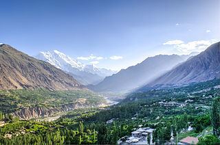
Several high peaks rise above 6,000 metres (20,000 ft) in the Hunza valley. The valley provides views of several tall mountains, including Rakaposhi 7,788 metres (25,551 ft), Ultar Sar 7,388 metres (24,239 ft), Bojahagur Duanasir II 7,329 metres (24,045 ft), Ghenta Sar 7,090 metres (23,261 ft), Hunza Peak 6,270 metres (20,571 ft), Darmyani Peak 6,090 metres (19,980 ft), and Bublimating (Ladyfinger Peak) 6,000 metres (19,685 ft). A watch tower is located in heart of Ganish Village, Baltit Fort stands on top of Karimabad whereas Altit Fort lies somewhat lower down the valley on another outcrop.
The valley is popularly believed to be the inspiration for the mythical valley of Shangri-la in James Hilton's 1933 novel Lost Horizon.
People of Hunza
The local languages spoken include Burushaski, Wakhi and Shina. The literacy rate of the Hunza valley is believed to be more than 90%. Virtually every child is educated up to at least high school level. The Life style of People of Hunza is very simple and they are considered to be very warm and welcoming.
Most of the inhabitants of Hunza are Ismaili Muslims, followers of His Highness Prince Karim Aga Khan IV, while in Ganish more than 65% are Shia Muslims.
The Hunza region is principally home to people of four ethnicities: