
Basin countries Pakistan Max. depth 358 feet (109 m) Water volume 407 million m³ | Max. length 13 miles (21 km) Length 20.9 km Inflow source Hunza River | |
 | ||
Location Attabad, Hunza Valley, Pakistan Primary inflows Primary outflows Hunza River overflowing landslide dam, 3,700 cu ft/s (100 m/s), 4 June 2010 | ||
N pakistan attabad lake
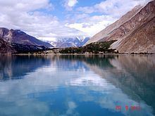
Attabad Lake, Hunza Valley, also known as Attabad Lake, is a lake in Ganish (Central Hunza Valley of northern Pakistan) created in January 2010 by a landslide dam.
Contents
- N pakistan attabad lake
- Map of Attabad Lake
- Trip to northern pakistan fairy meadows nanga parbat deosai attabad lake rama meadows lake
- Aftermath of landslide
- Karakorum Highway realignment
- Effect on local communities
- References
Map of Attabad Lake
The lake was formed due to a massive landslide at Attabad village in Gilgit-Baltistan, 9 miles (14 km) upstream (east) of Karimabad that occurred on 4 January 2010. The landslide killed twenty people and blocked the flow of the Hunza River for five months. The lake flooding has displaced 6,000 people from upstream villages, stranded (from land transportation routes) a further 25,000, and inundated over 12 miles (19 km) of the Karakoram Highway. The lake reached 13 miles (21 km) long and over 100 metres (330 ft) in depth by the first week of June 2010 when it began flowing over the landslide dam, completely submerging lower Shishkat and partly flooding Gulmit. The subdivision of Gojal has the greatest number of flooded buildings, over 170 houses, and 120 shops. The residents also had shortages of food and other items due to the blockage of the Karakoram Highway. By 4 June water outflow from the lake had increased to 3,700 cu ft/s (100 m3/s).
Water levels continued to rise in 18 June 2010 caused by a difference in the outflow and inflow of the new lake. As bad weather continued, the supply of food, medicine and other goods was stopped as all forms of transportation including helicopter service to Hunza could not resume.
Trip to northern pakistan fairy meadows nanga parbat deosai attabad lake rama meadows lake
Aftermath of landslide
Victims of the landslide and expansion of the lake staged a sit-in protesting the lack of government action and compensation payments to them.
As a result of the damming of Hunza River, five villages north of the barrier were flooded. One village, Ayeenabad, was completely submerged. Major portions of another village, Shishkat, was also submerged. Around 40% of the village of Gulmit, which also serves as the headquarters of Gojal Valley, was also submerged. Significant portions of land in Hussain and Ghulkin villages of Gojal also got submerged as a result of the surging lake.
The entire population of Hunza and Gojal valley, up to 25000 individuals, were affected as a result of the lake, due to difficulties of road access and reaching business markets and loss of land, houses, and agricultural products.
Attabad Lake has been visited by both current and former Prime Ministers Yousuf Raza Gillani and Nawaz Sharif, and by the Chief Minister of Punjab Shahbaz Sharif, Sharif announced Rs 100 million of aid for the victims from the Punjab government and Rs 0.5 million for the relatives of those who died in the landslide.
Areas downstream from the lake remained on alert despite some officials believing that a major flood scenario was less likely as the river began flowing over the landslide dam during the first week of June 2010. Many people have been evacuated to 195 relief camps. Two hospitals downstream, the Kashrote Eye Vision Hospital and the Aga Khan Health Service, evacuated both their staff and equipment. Some officials had incorrectly predicted that as soon as the lake began flowing over the landslide dam, a 60 feet (18 m) wave would hit the areas immediately downstream.
As of 14 June 2010, the water level continued to rise. DawnNews reported that "242 houses, 135 shops, four hotels, two schools, four factories, and several hundred acres of agricultural land" had been flooded, and that villagers were receiving food and school fee subsidies. They reported that 25 kilometres (16 mi) of the Karakoram Highway and six bridges were destroyed.
Frontier Works Organization blasted the spillway of the lake first on 27 March 2012 and then on 15 May 2012, lowering the lake's water level by at least 33 feet (10 m).
Karakorum Highway realignment
Part of Karakorum Highway was submerged due to this landslide. On 14 September 2015, Prime Minister of Pakistan performed inauguration of realigned 24 km patch of KKH containing five tunnels at Attabad Barrier Lake. The seven kilometre long five tunnels are part of the 24 km long portion of the Karakorum Highway (KKH) which was damaged in 2010 due to land sliding at Attabad. The realignment project is a construction masterpiece completed at the cost of $275 million. The realignment restored the road link between Pakistan and China and it is expected that significant amount of trade will be conducted between China and Pakistan using it. The KKH is also a part of the China Pakistan Economic Corridor and is expected to significantly increase economic integration between those two nations.
Effect on local communities
The Gojal Valley, which is worst affected as a result of this lake, is home to three small ethnic groups, namely the Wakhi (80%), Burushaski (18%), and Domaki (2%). The entire population of Domaki speakers, a very small minority and historically marginalised community, was displaced from their village of Shishkat.
The Wakhi and Burushaski speaking minority ethnic groups have also been affected severely as a result of the disaster.