
Elevation 6,768 m First ascent 20 July 1932 | Easiest route glacier/snow/ice climb Prominence 2,776 m | |
 | ||
Isolation 2,196 kilometres (1,365 mi) Listing Country high pointUltra Similar Alpamayo, Chopicalqui, Huandoy, Nevado Pisco, Tocllaraju | ||
Best tourist attractions in peru huaraz huascar n national park
Huascarán ([waskaˈɾan]) is a mountain in the Peruvian province of Yungay (Ancash Region), situated in the Cordillera Blanca range of the western Andes. The highest southern summit of Huascarán (Huascarán Sur) is the highest point in Peru, the northern part of Andes (north of Lake Titicaca) and in all of the Earth's Tropics. Huascarán is the fourth highest mountain in the Western Hemisphere and South America after Aconcagua, Ojos del Salado, and Monte Pissis. The mountain was named after Huáscar, a 16th-century Inca emperor who was the Sapa Inca of the Inca empire.
Contents
- Best tourist attractions in peru huaraz huascar n national park
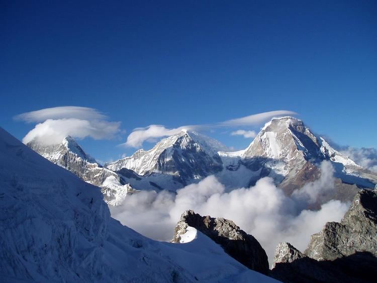
- Map of Nevado Huascaran Peru
- Huascar n national park tourist destination peru history and origin
- Geography
- Climbing
- Huascarn Norte
- Huascarn Sur
- 1970 earthquake
- References
Map of Nevado Huascaran, Peru
Huascar n national park tourist destination peru history and origin
Geography
The mountain has two distinct summits, the higher being the south one (Huascarán Sur) with an elevation of 6,768 metres (22,205 ft). The north summit (Huascarán Norte) has an elevation of 6,654 metres (21,831 ft). Both summits are separated by a saddle (called 'Garganta'). The core of Huascarán, like much of the Cordillera Blanca, consists of Cenozoic era granite.
Huascarán gives its name to Huascarán National Park which surrounds it, and is a popular location for trekking and mountaineering. The Huascarán summit is one of the points on the Earth's surface farthest from the Earth's center, closely behind the farthest point, Chimborazo in Ecuador.
The summit of Huascarán is the place on Earth with the smallest gravitational force.
Climbing
Huascarán is normally climbed from the village of Musho to the west via a high camp in the col that separates the two summits, known as La Garganta. The ascent normally takes five to seven days, the main difficulties being the large crevasses that often block the route. The normal route is of moderate difficulty and rated between PD and AD (depending on the conditions of the mountain) according to the International French Adjectival System.
The summit of Huascarán Sur was first reached on 20 July 1932 by a joint German–Austrian expedition. The team followed what would become later the normal route (named today Garganta route). The north peak (Huascarán Norte) had previously been climbed on 2 September 1908 by a U.S. expedition that included Annie Smith Peck, albeit this first ascent is somewhat disputed.
In 1989, a group of eight amateur mountaineers, the "Social Climbers", held what was recognised by the Guinness Book of Records (1990 edition) to be "the world's highest dinner party" on top of the mountain, as documented by Chris Darwin and John Amy in their book The Social Climbers, and raised £10,000 for charity.
The Huascarán massif spans from relatively easy to very challenging. The relative low technical difficulty of the normal route attracts many inexperienced climbers, so that a number of fatalities have occurred on the mountain.
Huascarán Norte
Apart from the normal route, climbed in 1908 and rated PD+/AD-, all the other routes are committing and serious.
- Northwest ridge ('Italian' route), rated ED1/ED2 climbed on 25 July 1974 by E. Detomasi, C. Piazzo, D. Saettone and T. Vidone.
- Northwest face ('Polish-Czech' variant), rated ED1/ED2, climbed on 14 July 1985 by B. Danihelkova, Z. Hoffmanova, A. Kaploniak, E. Parnejko and E. Szezesniak.
- North face ('Paragot' route), rated ED1, climbed on 10 July 1966 by R. Paragot, R. Jacob, C. Jacoux and D. Leprince-Ringuet.
- North face ('Swiss' route), rated ED2+, climbed on 23 May 1986 by D. Anker and K. Saurer. This route requires at least four days on the face.
- North face ('Spanish' route), rated ED2+ ,climbed on 20 July 1983 by J. Moreno, C. Valles and J. Tomas.
Huascarán Sur
As for the North summit, apart the normal route all the others are difficult.
- West ridge ('Shield' route), rated D+, climbed on 15 June 1969 by W. Broda, S. Merler and B. Segger. Approach as for the Garganta route but after the route develops over the knife-edge West ridge before getting to the summit icefield.
- West ridge direct ('Lomo fino' oroute), rated TD-, was climbed on 7 July 2007 by M. Ybarra and S. Sparano. Approach as for the Garganta route but after the route develops straight over the West face.
- Northeast ridge ('Spanish' route), rated TD+, was climbed on 18 July 1961 by F. Mautino, P. Acuna, A. Perez and S. Rivas. The route starts from Chopicalqui col, takes across the upper part of the Matara glacier and reaches the northeast ridge developing across cornices and snow mushrooms.
1970 earthquake
On 31 May 1970, the Ancash earthquake caused a substantial part of the north side of the mountain to collapse. The avalanche mass, an estimated 80 million cubic feet of ice, mud and rock, was about half a mile wide and a mile long. It advanced about 11 miles (18 km) at an average speed of 280 to 335 km per hour, burying the towns of Yungay and Ranrahirca under ice and rock, killing more than 20,000 people. At least 20,000 people were also killed in Huaraz, site of a 1941 avalanche which killed over 6000 (see Palcacocha Lake). Estimates suggest that the earthquake killed over 66,000 people.
Also buried by an avalanche was a Czechoslovak mountaineering team, none of whose 15 members were ever seen again. This and other earthquake-induced avalanche events are often described incorrectly as "eruptions" of Huascarán, which is not of volcanic origin.
An earlier avalanche on January 10, 1962, caused by a rapid rise in temperature, killed an estimated 4,000 people.