
Local time Sunday 12:42 AM Climate BSk | ||
 | ||
Weather 13°C, Wind S at 5 km/h, 87% Humidity | ||
A brief history lesson on the landslide in yungay peru
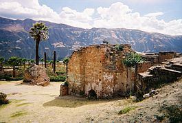
Yungay is a town in the Ancash Region in north central Peru, South America.
Contents
- A brief history lesson on the landslide in yungay peru
- Map of Yungay Peru
- Location
- History
- Ancash earthquake
- References
Map of Yungay, Peru
Location
Yungay is located in the Callejón de Huaylas on Río Santa at an elevation of approximately 2,500 meters, 450 km north of Lima, the country's capital. East of the small town are the mountain ridges of snow-covered Cordillera Blanca, with Huascarán, Peru's highest mountain, no more than 15 km east of Yungay.
Yungay is the capital of Yungay Province, as well as the main town in the Yungay District. While the town counts approximately 10,000 inhabitants (2010 projection based on 2007 census data) Yungay Province has a population of 60,000 (2000 estimate). The Province of Yungay occupies part of the Callejón de Huaylas, the Conchucos Valley (Yanama), the coast of Ancash (Quillo) and the Huascarán National Park.
History
The "Restoration" army, a Chilean-Peruvian army during the War of the Confederation, defeated the army of the Peru-Bolivian Confederation during the Battle of Yungay on January 20, 1839, marking the dissolution of the short-lived confederacy.
A remarkable event of the history of Peru happened in Yungay, where in the Guitarrero Cave US archeologist Thomas F. Lynch (Cornell University, 1969) discovered cultural vestiges from c. 10,000 BC, making this place "one of the great testimonies of the origin of agriculture in América".
Ancash earthquake
On May 31, 1970 the Ancash earthquake caused a substantial part of the north side of a mountain, Nevado Huascarán, to collapse and an unstable mass of glacial ice about 800 meters across at the top of Nevado Huascarán to fall. This caused a debris avalanche, burying the town of Yungay and killing 20,000 people. More than 50 million cubic meters of debris slid approximately 15 kilometers downhill at an angle of about 14 degrees. Speeds between 340 mph to 620 mph were achieved. Only 92 people survived, most of whom were in the cemetery and stadium at the time of the earthquake, as these zones were the highest in town.
The Peruvian government has forbidden excavation in the area where the old town of Yungay is buried, declaring it a national cemetery. The current town was rebuilt 1 mile north of the destroyed city.
In 1962 two American scientists, David Bernays and Charles Sawyer, had reported seeing a massive vertical slab of rock being undermined by a glacier, which threatened to fall and cause the obliteration of Yungay. According to Sawyer, when this was reported in the Espreso newspaper (27 September 1962), the government ordered them to retract or face prison, and they fled the country. Citizens were forcibly prevented from speaking of an impending disaster. Eight years later the prediction came true.