
Population 362 (2011) Post town YORK | OS grid reference SE667528 Sovereign state United Kingdom Local time Wednesday 3:14 PM | |
 | ||
Weather 14°C, Wind SW at 23 km/h, 61% Humidity | ||
Hovingham village hall community project
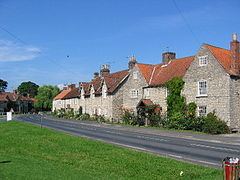
Hovingham is a large village and civil parish in the Ryedale district of North Yorkshire, England. It is on the edge of the Howardian Hills and about 7 miles south of Kirkbymoorside.
Contents
- Hovingham village hall community project
- Map of Hovingham York UK
- History
- Governance
- Geography
- Education
- Village services
- Sports
- Religion
- Notable buildings
- References
Map of Hovingham, York, UK
History
The village is mentioned in the Domesday Book by its current name and lay within the Maneshou hundred. The lands at the time of the Norman invasion belonged to Orm, son of Gamal. After the invasion, the lands were granted to Hugh, son of Baldric. The etymology comes from a combination of houc meaning a place of graves, ing meaning a meadow near a river, and ham meaning a settlement.
There is evidence of Roman activity around the village which sat on the Malton to Aldburgh road in those times. During the construction of Hovingham Hall gardens, a Roman bath, tessalted pavement and other artefacts were uncovered.
The village used to be a stop on the Malton & Thirsk branch of the North Eastern Railway.
Governance
The village is within the Thirsk and Malton UK Parliament constituency. It is also part of the Hovingham & Sheriff Hutton electoral division of North Yorkshire County Council and the Hovingham ward of Ryedale District Council. The local Parish Council is a joint one with nearby Scackleton and the council has seven members including the Chair.
An electoral ward in the same name exists. This ward stretches south to Terrington with a total population taken at the 2011 Census of 1,656.
Geography
The 1881 UK Census recorded the population as 600. According to the 2001 UK Census, the population was 371, of which 300 were over sixteen years old and 174 of those were in employment. There were 166 dwellings, of which 59 were dsetached. The population at the 2011 Census had marginally reduced to 362.
The nearest settlements are Slingsby 1.75 miles (2.82 km) to the east; Stonegrave 1.6 miles (2.6 km) to the north; Cawton 1.9 miles (3.1 km) to the north-west; Coulton 2.2 miles (3.5 km) to the west south-west and Scackleton 2.1 miles (3.4 km) to the south-west. The village lies at an elevation of 215 feet (66 m) at its highest point and is on the B1257 Malton to Stokesley road. Marr's Beck flows northwards through the village to eventually join the River Rye near Butterwick.
Education
There is one school in the village, Hovingham Church of England Voluntary Controlled Primary School, built by Lady Worsley in 1864 and extended in 1888. It is a Grade II Listed Building. The school lies within the catchment area of Malton School for secondary education.
Village services
The village is served by the bus route from Malton to Helmsley. There is a village shop as well as a bakery and tea room, a hotel, a public house and other local businesses.
Sports
Hovingham Cricket Club run teams at many level, with the Senior team competing in the York & District Cricket League. The village also runs a Tennis Club.
Religion
There is a Grade II listed church in the village dedicated to All Saints. The majority of the present church building dates back to 1860, when it was rebuilt at the expense of Marcus Worsley. The tower of the parish church of All Saints is of Saxon origin. An interesting feature is the large 10th-century altar cross.
There is also a Methodist church in the village, which is Grade II Listed Building.
Notable buildings
Hovingham has been home to the Worsley family since 1563 and was the childhood home of the Duchess of Kent. The sixth Thomas Worsley (1710–1778) designed and built the current Hovingham Hall. A unique feature of the Grade I listed building is that it is entered through a covered Riding School, once used for training horses.
In addition to the Hall, the School and the two Churches, there are a total of 49 other Listed Buildings in the area.