
Country United States GNIS feature ID 1374161 Zip code 77008 | Time zone Central (CST) (UTC-6) Elevation 18 m | |
 | ||
Area code Area code(s) 281, 346, 713, and 832 Similar Heights High School, Downtown Houston, Houston | ||
Houston Heights (often referred to simply as "The Heights") is a community in northwest-central Houston, Texas, United States. "The Heights" is often referred to colloquially to describe a larger collection of neighborhoods next to and including the actual Houston Heights. However, Houston Heights has its own history, distinct from Norhill and Woodland Heights.
Contents
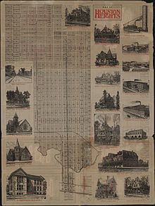
- Map of Houston Heights Houston TX 77008 USA
- Houston heights home for sale 415 e 14th st houston tx 77008 heights houston realtor
- History
- Cityscape
- Local government
- County state and federal representation
- Demographics
- Age Breakdown
- Transportation
- Culture
- Media
- Colleges and universities
- Primary and secondary schools
- History of schools
- Public libraries
- Parks and recreation
- Community Information
- Climate
- Notable residents
- References
Map of Houston Heights, Houston, TX 77008, USA
Houston heights home for sale 415 e 14th st houston tx 77008 heights houston realtor
History
By 1891 millionaire Oscar Martin Carter and a group of investors established the Omaha and South Texas Land Company. The company purchased 1,756 acres (7.11 km2) of land and established infrastructure, including alleys, parks, schools, streets and utilities, worth $500,000 United States dollars. When Houston Heights was founded, it was a streetcar suburb of Houston which attracted people who did not wish to live in the dense city. It had its own municipality until the City of Houston annexed the Heights in 1919.
After World War II industrial interests moved into the Houston Heights. Marilyn Bardsley of Crime Library stated that the Houston Heights became "decrepit" and "tired" after World War II. In the 1970s the Houston Heights was considered to be a low income area of the city. On December 13, 1970 Dean Corll began luring and killing children from the Houston Heights as part of the Houston Child Murders. For most of the period of his crime spree, Corll lived in or close to Houston Heights as his two teenage accomplices resided there. Other teens from the area were targeted simply because the two teens knew many of them which made it easier to entice them to Corll's various residences during the period.
From the 1980 U.S. Census to the 1990 Census, the population of the Houston Heights declined by more than 1,000 people per square mile. The Houston Heights Association opened in 1973.
Since the 1990s, and similar to other parts of Houston inside the 610 Loop, the Heights has experienced gentrification, a process ongoing to this day, as young highly paid professionals (many of whom work in Downtown Houston) have flocked to the area, purchasing and renovating some of the historic homes (and demolishing some of them to build newer, upscale housing). Upscale boutiques and restaurants have opened in the area, giving the streetscape an appearance not too much unlike Bellaire, Lower Westheimer or Upper Kirby.
The 7,000-square-foot (650 m2) former fire station at 12th Street at Yale Street was constructed as Houston Heights' city hall and jail, and fire station in 1914. After annexation, it served as a city of Houston fire station from 1918 until 1995. The Houston Heights Association took a 30-year lease on the property from the city and refurbished the property. By December 2009 the former city hall was for sale.
In 2013 CNN Money ranked the Houston Heights as no. 4 in its Top 10 big city neighborhoods ranking.
Cityscape
The Houston Heights, one of the earliest planned communities in Texas, is located 4 miles (6.4 km) northwest of Downtown Houston. A National Geographic article says "stroll the area's broad, tree-canopied esplanades and side streets dotted with homes dating from the early 1900s and you may think you've landed in a small town." John Nova Lomax said that the Heights, which he describes as "Houston's own mini-Austin," had many "low-key" restaurants and beer gardens. The Houston Heights Association describes the Heights as being bounded by Interstate 10 on the south, North Shepherd Drive on the west, Interstate 610 on the north and both North Main and Studewood Streets on the east.
According to a study of the University of Houston Institute of Regional Forecasting and Crawford Realty Advisors, from 2002 to 2003 prices of single family houses appreciated by 8.7 percent. Anjali Athavalley said "[r]eal estate agents say most houses there costing less than $200,000 need serious work" and "[b]uying a single-family house in the Houston Heights, for example, is getting expensive."
In 1976 James Conaway of the Texas Monthly described the Heights as a "seedy, lower-middle-class enclave with horizons limited to once-fashionable homes divided into low-rent apartments, and guarded by pickups on concrete blocks."
Local government
By 2000 Houston Heights community retained its prohibition of the sale of alcoholic beverages. The Houston Heights passed a prohibition on alcoholic beverages in 1912, and the annexation agreement followed by the City of Houston stipulates that much of the Heights must retain the ban on alcoholic beverages. Many restaurants in the zone got around the ordinance by forming private clubs that patrons may join so that the patrons can order alcoholic beverages.
The Houston Fire Department operates Station 15 Heights in the Northside district, near the Houston Heights. It is a part of Fire District 6. Fire Station 15 moved to Houston Avenue and North Main in 1918 and North Main at Tabor in 1942. The current station at Dunbar and North Main opened in 1999.
The Houston Police Department's Central Patrol Division serves the neighborhood. The Heights Storefront is located at 910 North Durham.
As of 2011 most of the Heights is a part of Houston City Council District C, while a portion is in District H. Because of the inclusion of the Heights, Montrose, and Rice University areas, it has the nickname "Hipstrict" for what Chris Moran of the Houston Chronicle refers to as its "progressive, urban ethic." Before the 2011 redistricting, District H included all of the Houston Heights. H was mostly Hispanic, but because of the inclusion of the Houston Heights, it was becoming increasingly non-Hispanic White. Around 2011 an earlier plan would have combined the Heights and Montrose under a district called District J.
In a 1989 Houston Chronicle article Alan Bernstein described political support for Jim Westmoreland, an incumbent in an at-large position, in the Houston Heights as "relatively weak." In one precinct 49.4 percent of the voting residents voted for him. Westmoreland drew controversy after reports of a joke that was characterized as "racist" spread. Beverley Clark, the opponent and a Black teacher, defeated Westmoreland in that race. Bernstein said that the significant racial minority groups and the "social tolerance" trait may have contributed to backlash against Bernstein. In a 1989 Houston Chronicle article, Randy Cypret, the president of the Houston Heights Association, said that the split vote from the Houston Heights may reflect the ethnic division. Cypret added that opposition may have stemmed from Westmoreland's lack of political presence in the Houston Heights and a lack of advocacy for zoning-related issues. Cypret said that he opposed Westmoreland because of "the fact that he considers being on the city council a part-time job. In the fourth largest city in the Country, you should take your job more seriously."
County, state, and federal representation
The area United States Postal Service office is the Heights Post Office at 1050 Yale Street, but the post office is scheduled to close on December 30, 2015. Operations and post office boxes are moving to the TW House Station located at 1300 West 19th Street.
Demographics
The paper "Houston Heights" by Carolee Gearheart of the Aspen Systems Corporation - Housing Research Group and three University of Houston professors describe the Houston Heights as having a "diverse population." A National Geographic article said that the Houston Heights "is said to be home to the highest concentration of professional artists" in Texas.
According to the 2000 census, the current population of the Super Neighborhood #15 Greater Heights, which includes the Houston Heights and several surrounding subdivisions [2] [3], is 41,486.
Age Breakdown
This is the age breakdown of Super Neighborhood #15 Greater Heights.
Transportation
Metropolitan Transit Authority of Harris County, Texas (METRO) operates the Heights Transit Center.
Bike Trails : The MKT/SP Trail is a Rails-to-Trails conversion project of 4.62 miles made up of a 10-foot wide, concrete, multi-use hike and bike trail along the old Missouri, Kansas, Texas Southern Pacific railroad right-of-way.
The trail runs from 26th Street to 7th Street along Nicholson, and from Shepherd along 7th Street, to Spring Street, across White Oak Bayou, and under I-45, where it connects to the Heritage Corridor West Trail providing a connection to the University of Houston and other downtown bikeways and destinations.
Culture
A National Geographic Traveler article stated that the Houston Heights "maintains a quirky sense of individuality" and "flourishes as a destination for foodies, architecture buffs, and creative types."
Doug's Barbershop on 11th Street was featured in the 1998 film Rushmore, directed by Wes Anderson. Doug's has also been featured in various television and print advertisements due to its classic barbershop decor.
Media
The Houston Chronicle is the citywide newspaper.
The headquarters of Houstonia magazine is in the Houston Heights.
Colleges and universities
Houston Community College provides community college services.
The Gulf Coast Bible College was located in the Houston Heights. While it was there, it tried to form its own campus by buying and tearing down houses. In 1984 the college announced it was moving to Oklahoma City, Oklahoma. In June 1985 the college moved. In August of that year the college was still trying to sell the Houston Heights campus.
Primary and secondary schools
The Heights is served by Houston Independent School District (HISD). It is in Trustee District I, represented by Anna Eastman as of 2015. HISD's Central Region offices were located in the Houston Heights in the former Holden Elementary building. Prior to Houston ISD's 2005 reorganization, the North Central District was headquartered in the Cooley Facility in the Heights.
Elementary schools that serve portions of the Houston Heights include Field, Harvard, Helms Community Learning Center, Love, and Sinclair. Middle schools that serve portions of the Houston Heights include Hamilton and Hogg. High schools that serve portions of the Houston Heights include Heights High School (formerly John H. Reagan High School) and Waltrip High School. The Arabic Language Immersion School, a magnet elementary school, opened in the former Holden Elementary School location in the fall of 2015.
Helms has a Spanish-English bilingual program that began in 1996 as a partnership with the University of St. Thomas. Shell Oil Co. founded a learning laboratory at Helms with a $500,000 grant. By 2008 the Ministry of Education of the Spanish Embassy named Helms an "International Spanish Academy".
Two state charter schools are located in the Heights; they are: Houston Heights Learning Academy [4] and Houston Heights High School. Three private schools, a K-9 school called The New School in the Heights, Immanuel Lutheran Church and School (K-8) and Houston Outdoor Learning Academy, a 6-12 private school, are in the Houston Heights.
History of schools
The first elementary school to open in the Houston Heights was Cooley Elementary School, which opened in 1894. Harvard Elementary School opened in 1898. In 1914, a businessman donated land for a new elementary school, which became Love Elementary School. Helms Elementary School was built in 1918, and opened in 1921. It was named after a member of the Houston Heights school board and had a cost of $49,000. Within the Heights, the city's budget became increasingly less able to support the educational needs of the city's population. This influenced the decision to allow the City of Houston to annex the Houston Heights.
Houston Heights Senior High School opened in 1919. Harvard became a part of Houston ISD in 1921 and Love moved to its current location in 1923. In 1925 Heights High School became Hamilton High School. In 1926 Love received a new campus, Hogg opened, and Reagan opened; Hamilton became a junior high school that year. Field opened in February 1929. Sinclair and Waltrip opened in 1959. During the same year, Twenty-Third Street Elementary School in the Houston Heights received fire damage, so it closed. In 1960 Holden Elementary School opened on the site of the former Twenty-Third Street Elementary School. In 1965, Cooley was renovated.
Cooley closed in 1980. Shortly afterwards HISD began housing offices in the Cooley building. In 1997 a small portion of the Houston Heights was rezoned to Waltrip. In 2001 Helms received its current name. Holden closed in May 2004 and students were rezoned to Sinclair and Helms; at the time 52% of students zoned to Holden were enrolled in Holden. Eighth Avenue Elementary School, which served a portion of the Houston Heights, closed after the HISD board voted to close it in 2004. Students were rezoned to Love Elementary.
The building at the Cooley site served as the headquarters of HISD's alternative certification program until 2010, when the location was sold to a home builder. The former Holden Elementary building was used for Energy Institute High School for school year 2013-2014 and later the Arabic Immersion Magnet School.
Previously Crockett Elementary School in the Sixth Ward served a small section of the Houston Heights. A 2015 rezoning proposal was presented that would remove the portion of the Crockett boundary north of Interstate 10. These sections were rezoned to Harvard and Travis, with two students affected.
In 2015 Field Elementary applied to have a magnet program for theater and media arts.
In 2016 residents in the Love Elementary attendance area proposed adding a magnet program to Love Elementary so it could attract a wider variety of students and additional financial support from the community. As of that year it had fewer than 500 students; 88% of its students were Hispanic or Latino, 7% were white, and 89% were considered low income. Its demographics and level of financial support strongly contrast with other Heights area elementary schools.
Public libraries
The Heights Neighborhood Library of the Houston Public Library is located at 1302 Heights Boulevard. The blaxploitation film Sugar Hill (1974) depicted the library as the "Voodoo Museum of Natural History."
Parks and recreation
The City of Houston operates parks within and around the Houston Heights. The Heights Boulevard Park is located at 100-1900 Heights Boulevard. Milroy Park and Community Center has a playground and lighted tennis courts. Love Park and Community Center are adjacent to the Houston Heights. Love Park has an outdoor basketball pavilion, a 0.2-mile (0.32 km) hike and bicycle trail, a playground, a lighted sports field, and a swimming pool. Love Community Center has an indoor gymnasium, meeting rooms, and a weight room. In addition the Houston Heights World War II Memorial is located in the Heights.
The Heights is the locale of Houston's White Linen Night, held annually in late July or early August.
Community Information
The Houston Heights Association was organized in 1973 by residents and business owners to work together toward maintaining the quality of life and preserving the historic character of the community. The association owns several properties, one of which is Marmion Park, which is at the original location of the Cooley mansion, one of the first houses built in Houston Heights. The house was demolished in 1965. The land was purchased in 1979 by the Houston Heights Association for the purpose of constructing Marmion Park, named in honor of the last mayor of Houston Heights, J. B. Marmion.
The Houston Heights Woman's Club was founded in 1900, and constructed its own club building in 1912, which is still in use. Members were active in the suffrage movement, and later, during both World Wars volunteered the club for use by the Red Cross. Today the club volunteers in efforts to improve the Heights neighborhood, in particular mentoring children and assisting the elderly.
Climate
The climate in this area is characterized by hot, humid summers and generally mild to cool winters. According to the Köppen Climate Classification system, Houston Heights has a humid subtropical climate, abbreviated "Cfa" on climate maps.