
Country Turkey Climate Cfa Elevation 10 m Local time Tuesday 4:57 PM | Post code 08600 Website www.hopa.bel.tr Area 389 km² | |
 | ||
Weather 8°C, Wind W at 2 km/h, 88% Humidity | ||
Dimitri vegas like mike vs kshmr hopa
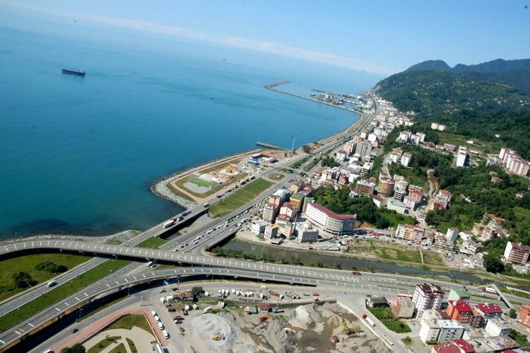
Hopa (Georgian: ხოფა, ხუფათი) is a city and district of Artvin Province in northeast Turkey. It is located on the eastern Turkish Black Sea coast about 67 km (42 mi) from the city of Artvin and 18 kilometres from the border with Georgia.
Contents
- Dimitri vegas like mike vs kshmr hopa
- Map of Hopa 08600 Hopa2FArtvin Turkey
- Dimitri vegas like mike vs kshmr id hopa higher quality
- Geography
- History
- Economy
- Well known citizens
- Climate
- References
Map of Hopa, 08600 Hopa%2FArtvin, Turkey
Dimitri vegas like mike vs kshmr id hopa higher quality
Geography
Hopa is on the Black Sea Coast 65 km from Artvin and 18 km from the Sarp border crossing (into Sarpi) on the Georgian border. The land climbs sharply from 10m above sea level in the coastal areas up into the Sultan Selim Mountains, the hillsides are well watered and green with alder, chestnuts, hornbeams and other deciduous trees. The highest point is Mt Yavuz Sultan Selim at 1513m. The climate is mild and wet, although only July and August are warm enough to be called summer. There is annual snowfall in winter.
History
The area was part of the kingdom of Colchis but was always vulnerable to invasions, first the Scythians from across the Caucasus, then the Muslim armies led by Habib, son of Caliph Uthman who controlled the area from 853 AD to 1023 when it was conquered by the Byzantines from the Sac Emirate allied to the Abbasids. The Seljuk Turks led by Alp Arslan conquered the area in 1064. With the collapse of the Seljuks, the Artvin area came under the control of the Ildeniz, one of the Anatolian Turkish beyliks
Ottoman Sultan Selim I brought it into the Ottoman Empire during his campaign against the Crimea that took place in 1490-1512. Lala Mustafa Pasha made it part of the Çıldır Eyalet formed in 1578. The area was captured by Russia following the Russo-Turkish War (1877-1878) and many people of Hopa moved westwards away from the Russian-controlled zone. Hopa was returned as part of the Brest Litovsk Agreement in 1918 and formally joined Turkey on 14 March 1921. The Sarp border gate was opened on 31 August 1988 with the "International Road Transport Agreement" between Soviet Union and Turkey and gave a big boost to Hopa in trade and tourism.
There is currently a high rate of cancer in Hopa, attributed to fall-out from the disaster at Chernobyl, across the Black Sea from here. Between 2001 and 2004, cancer cases sharply increased in the Black Sea region, especially in Hopa, with 47.9% of all deaths during this time being due to cancer.
Economy
The economy is based on trade, fishing and agriculture, mostly tea, nuts (especially Hazelnuts) and kiwifruit. There are two tea factories, the Black Sea Copper Works, a Thermal Power Plant, the Hopa port and the Hopa Vocational School. It has direct railway connections to Trabzon, Rize, Artvin, Ardahan, Kars, Erzurum and Sarp which go on to Georgia. The Sarp border gate was opened on 31 August 1988 with the "International Road Transport Agreement" between Soviet Union and Turkey and gave a big boost to Hopa in trade and tourism. The Hopa Port is managed by a privately owned company Hopa Limani and is active in international trade.
Well-known citizens
Climate
This area is characterized by equable climates with few extremes of temperature and ample precipitation in all months. The Köppen classification for this climate is Cfb (Oceanic climate).