
Elevation 1,257 ft (383 m) Pronunciation /ˈhuːʒər/ Easiest route Hiking | Prominence 297 ft (91 m) Topo map USGS Spartanburg | |
 | ||
Listing U.S. state high point 44th Similar Campbell Hill, Weed Patch Hill, Charles Mound, Ebright Azimuth, Jerimoth Hill | ||
Hoosier Hill is the highest natural point in the state of Indiana at 1,257 feet (383 m) above sea level. It is in the rural area of Franklin Township, Wayne County to the northwest of Bethel. The nearest intersection to the high point is Elliot Road and County Line Road. The nearest major landmark is Interstate 70 and Richmond 11 miles (17.5 km) to the south.
Map of Hoosier Hill, Franklin Township, IN 47341, USA
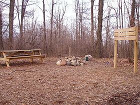
The Hill sits on private property; the high point sits in a forested area surrounded by farmland. In 2005, an Eagle Scout candidate named Kyle Cummings (Troop 820 from Lakeside Park, Kentucky), in cooperation with the property owner, built a trail, sign and picnic area at the high point.
Geologically, the hill sits in the Dearborn Upland, an area of high terrain in southeast Indiana that sits on top of the geologic structure known as the Cincinnati Arch. However, Hoosier Hill is located in a portion of the upland buried underneath glacial debris known as the Tipton Till Plain. As a result, while the average elevation of this upland region is 1100 +/-100 feet above sea level, the topographic relief is gentle where the "hill" is no more than 30 feet higher than the surrounding landscape of gently rolling farmland. While the high topography seen at Brown County State Park, which sits in the Norman Upland in south central Indiana, can be mistaken to be a high point (where relief is 400–500 feet from valley to hilltop), the elevations of hilltops ranges from 800–1050 feet.
A.H. Marshall was the first person to successfully climb each U.S. state highpoint. He completed the task in 1936 after standing atop Hoosier Hill.