
- elevation 2,920 ft (890 m) Length 6 km Basin area 383.3 km² | - elevation 2,338 ft (713 m) - elevation 935 ft (285 m) Basin area 383.3 km² Source Left Fork Holly River | |
 | ||
- location north-central Webster County | ||
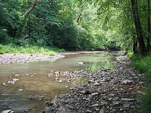
The Holly River is a tributary of the Elk River in central West Virginia in the United States. Via the Elk, Kanawha, and Ohio Rivers, it is part of the watershed of the Mississippi River, draining an area of 148 square miles (380 km2) in a rural region of the Allegheny Mountains. It is approximately 3.9 miles (6.3 km) long, or 28 miles (45 km) including its Left Fork. The river was named for the holly bushes along its course.
Map of Holly River, Eastern, WV, USA
The Holly River is formed by the confluence of its Left Fork and its Right Fork:
From the confluence of its left and right forks, the Holly River flows westward 3.9 miles (6.3 km) as an arm of Sutton Lake, formed by a dam on the Elk River, to its mouth approximately 9 miles (14 km) east of Sutton. The Holly River’s course and the lower reaches of the left and right forks are part of the Elk River Wildlife Management Area.
According to the West Virginia Department of Environmental Protection, approximately 97% of the Holly River watershed is forested, mostly deciduous. Approximately 2% is used for pasture and agriculture.