
Vehicle registration HSK | Time zone CET (UTC+1) Population 268,851 (30 Jun 2010) | |
 | ||
Points of interest Ruhr, Kahler Asten, Skiliftkarussell Winterberg, Fort Fun Abenteuerland, Postwiesen Skigebiet Neuastenberg Destinations | ||
Hochsauerlandkreis (meaning “High Sauerland District” in German) is a Kreis (district) in the east of North Rhine-Westphalia, Germany. Neighboring districts are Soest, Paderborn, Höxter, Waldeck-Frankenberg, Siegen-Wittgenstein, Olpe, Märkischer Kreis.
Contents
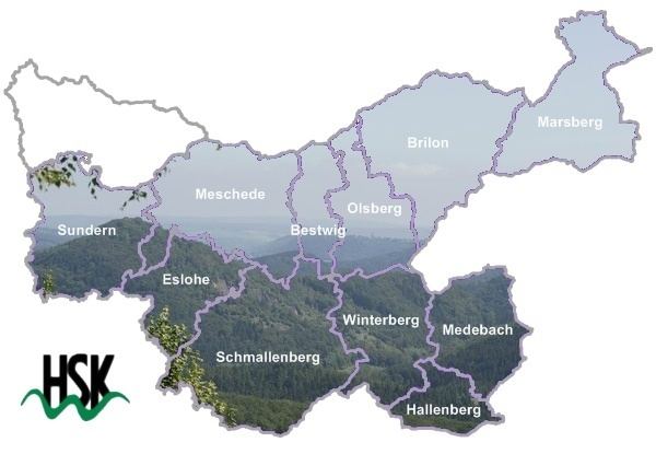
- Map of Hochsauerlandkreis Germany
- History
- Geography
- Town twinnings
- Notable persons
- Notable places
- References
Map of Hochsauerlandkreis, Germany
The district is named “High Sauerland” because two of the highest mountains of the Sauerland mountainous landscape, Langenberg and Kahler Asten are in its territory. With 2,766 ft / 843 m (Langenberg) and 2,762 ft / 842 m (Kahler Asten) these are also the highest mountains of North Rhine-Westphalia.
History
The district was established in 1975 in the reorganization of the districts in North Rhine-Westphalia by merging the previous districts Arnsberg, Brilon and Meschede.
Geography
Geographically the district covers a big part of the Sauerland mountains, including the highest and third highest elevation – the Langenberg near Olsberg with 2,766 ft / 843 m, and the better known Kahler Asten with 2,762 ft / 842 m near Winterberg. These are also the two highest mountains of North Rhine-Westphalia.
Town twinnings
Hochsauerland is twinned with the following cities: