
Palestine grid 175/138 Name meaning "The bundle" | ||
 | ||
Weather 11°C, Wind W at 13 km/h, 75% Humidity | ||
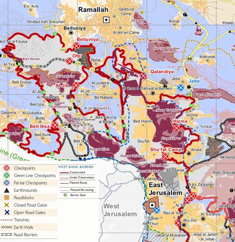
Hizma (Arabic: حزما; Hebrew: חיזמה) is a Palestinian town in the Jerusalem Governorate, seven kilometers from Jerusalem's Old City. The town, located in Area B, borders the Israeli settlements Neve Yaakov, Pisgat Ze'ev located in East Jerusalem and the settlements Geva Binyamin and Almon. A small eastern neighbourhood of Hizma is called Hizmah. Since 1967, Hizma is occupied by Israel. The village is cut off from Jerusalem by the Israeli West Bank barrier in the west, controversially built after a wave of suicide bombings from the occupied West Bank. As of 2007, Hizma had a population of about 5650 residents. Hizma is cut off from the West Bank by a chain of Israeli settlements in the east.
Contents
- Map of Hizma
- History
- Ottoman era
- British Mandate era
- 1948 1967
- 1967 present
- West Bank barrier
- Israeli administration
- Economy
- References
Map of Hizma
History
Albright and others identified Hizma with the biblical town of Azmawt of the Israelite tribe of Benjamin. However, Gibson more recently questioned this identification, citing the lack of archaeological remains from the necessary time period. Towards the end of the Second Temple period, there was an industry here making fine stoneware from the local limestone. Products included vases and bowls turned on a lathe, and mugs carved by hand. Examples of stoneware that may have originated here have been found in many places in the Jerusalem region, mostly dating from the first and second centuries CE.
Ottoman era
In 1517, the village was incorporated into the Ottoman empire with the rest of Ottoman Syria, and in the 1596 tax-records it appeared as Hamza, located in the Nahiye of Jerusalem in the Sanjak of the Mutasarrifate of Jerusalem. The population was 28 households, all Muslim according to census records. They paid a tax rate of 33,3% on agricultural products, which included wheat, barley, vineyards and fruit trees, occasional revenues, goats and beehives; a total of 2800 Akçe.
In 1832, Edward Robinson found the village had been deserted for two months, as the villagers had "fled across the Jordan" to escape conscription. In 1863 Victor Guérin found the village to have 200 inhabitants. He further noted that some of the houses, particularly the lower part, seemed to be built from ancient materials, and some cisterns also looked ancient.
An Ottoman village list of about 1870 showed 51 houses and a population of 150, though the population count included only the men. In 1883, the Palestine Exploration Fund's Survey of Western Palestine (SWP) described Hizma as a "small stone village, standing high on a prominent hill, the slopes of which are covered with olives. It has a well to the west."
British Mandate era
In the 1922 census of Palestine, conducted by the British Mandate authorities, Hizma had a population of 515 increasing slightly in the 1931 census to 521 in 91 inhabited houses.
In 1945 the population of Hizma was 750, all Muslims, and the total land area was 10,438 dunams of land according to an official land and population survey. Of this, 200 dunams were plantations and irrigable land, 2,338 for cereals, while 45 dunams were built-up (urban) land.
1948-1967
In the wake of the 1948 Arab–Israeli War, and after the 1949 Armistice Agreements, Hizma came under Jordanian occupation.
1967-present
Since the Six-Day War in 1967, Hizma has been under Israeli occupation.
In the 1970s 19% of the village's total area was used to establish the settlements of Neve Ya'akov, Pisgat Ze'ev and Pisgat Amir, which are considered illegal by the international community. Under the Oslo II Accord, about 9% of the village area was assigned as Area B; administered by both the PA and Israel, and the remaining 91% became Area C, administered by Israel.
There is a bypass road connecting the settlements with the neighboring Israeli settlements. There is also a buffer zone of 75 meters along the roads on each side. Palestinians in Gaza and the West Bank are prohibited from using these roads, only Israelis and foreign nationals can use them, the status purpose being security concerns.
West Bank barrier
The Israel-West Bank barrier cuts off 40% of the village's area, with the Israeli side incorporating the settlements and surrounding forests, agricultural lands, open spaces, and a small part of the Palestinian residential area. As of 2012, An Israeli checkpoint located west of the village at an opening in the controls the passage to and from Hizma. Palestinians living outside Jerusalem, Israel's self-declared and unrecognized capital, must have a special permit that is reportedly hard to obtain. Israeli citizens (including settlers) and permanent residents (including Palestinians in East Jerusalem) are allowed to pass in and out without any permits.
Israeli administration
Israeli authorities demolish the homes of Palestinians built without permits. Strict conditions for Palestinians applying for permits must be fulfilled and the permits are usually denied.
The village has on occasion been sealed off with road blocks in response to reported stone-throwing and rioting, characterized by many rights groups as a form of collective punishment.
Economy
In 2010, more than half of the workforce was working in the government or private employees sector; 22% was working in the Israeli labor market, 14% on agriculture, and 7% worked in the trade sector.
Hizma village is known for the cultivation of olives; 112 dunums of land were cultivated with olive trees in 2010. Cereals were grown on 233 dunums.