
Department Aisne Population (2012) 9,348 Local time Sunday 5:34 AM | Canton Hirson Area 33.77 km² | |
 | ||
Intercommunality Communauté de communes du Pays des Trois Rivières Weather 4°C, Wind E at 11 km/h, 79% Humidity | ||
Hirson is a commune in the Aisne department in Hauts-de-France in northern France.
Contents
- Map of 02500 Hirson France
- Location
- Hydrography
- Geology and Relief
- Neighboring municipalities
- History
- Population
- Monuments
- References
Map of 02500 Hirson, France
Location
Hirson is adjacent to Belgium. It is located in the northeastern department of Aisne, near the departments of Nord and Ardennes. Hirson is part of Thiérache. It is located near two large forests, the forest of Hirson and the forest of Saint-Michel.
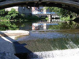
Hydrography
Hirson is watered by the Oise and Gland. The various streams of the town: stream of Anor, stream of Brugnon, stream of La Marquette, stream of Les Marais, stream of Blangy, stream of Le Catelet, stream of Le Rie De Bon Feu, stream of Four Matot.
Geology and Relief
The culmination of Hirson is located 268 meters above sea level. The lowest altitude is 157 meters above sea level.
Neighboring municipalities
Hirson is bordered by eight municipalities: Eparcy, Buire, Neuve-Maison, Mondrepuis, Anor (Nord), Momignies (Belgium), Saint-Michel, Bucilly.
History
As of 1911, there was a permanent fort and two artillery batteries near the railway junction. Also at that time, the town was engaged in the manufacture of glass bottles, tiles and iron and tin goods, as well as wool-spinning and brewing.
The town is served by the Fives-Hirson railway.
Population
The inhabitants of the town are called Hirsonnais.
Monuments
churches