
Length 50 km (31 mi) Highest elevation 763 m (2,503 ft) Area 850.2 km² | Area rank 3rd largest in Norway Width 40 km (25 mi) Peak Snøkolla | |
 | ||
Municipalities Bø, Nordland, Hadsel, Sortland, Øksnes | ||
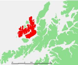
Langøya is the third largest island of Norway (except for Svalbard), with an area of 850.2 square kilometres (328.3 sq mi). The island is a part of the Vesterålen archipelago and is situated in Nordland county. The island includes the municipalities of Bø and Øksnes as well as parts of the municipalities of Sortland and Hadsel.
Map of Lang%C3%B8ya, Norway
The large island of Hinnøya lies to the east (on the other side of the Sortlandssundet). The island of Andøya lies to the northeast. The small island of Skogsøya lies to the northwest. The island of Hadseløya lies to the south. There are several lakes on the island including Alsvågvatnet. The Eidsfjorden divides the island almost in half. The island has two road bridges connecting it to Hadseløya and Hinnøya via the Hadsel Bridge and Sortland Bridge.