
Congressional district 7th Website www.co.hillsdale.mi.us Founded 1855 Unemployment rate 4.9% (Apr 2015) | Area 1,572 km² Population 46,101 (2013) | |
 | ||
Rivers Saint Joseph River, Lime Creek, Bean Creek | ||
Hillsdale County is a county located in the U.S. state of Michigan. As of the 2010 census, the population was 46,688. The county seat is Hillsdale.
Contents
- Map of Hillsdale County MI USA
- History
- Geography
- Parks
- Adjacent counties
- Climate
- Demographics
- Government
- Elected officials
- Major highways
- Airports
- Trails
- Cities
- Villages
- Notable people
- References
Map of Hillsdale County, MI, USA
Hillsdale County comprises the Hillsdale, MI Micropolitan Statistical Area.
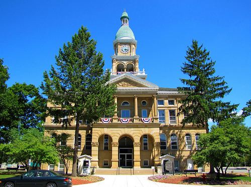
The Hillsdale County Courthouse was built by Claire Allen, a prominent southern Michigan architect.
History
The county is named for its rolling terrain. It was set off in 1829, and organized six years later. See List of Michigan county name etymologies. Hillsdale County was a New England settlement. The original founders of Hillsdale consisted entirely of settlers from New England. These people were "Yankees", that is to say they were descended from the English Puritans who settled New England in the 1600s. They were part of a wave of New England farmers who headed west into what was then the wilds of the Northwest Territory during the early 1800s. Most of them arrived as a result of the completion of the Erie Canal as well as the close of the Black Hawk War. When they arrived in what is now Hillsdale County there was nothing but a virgin forest and wild prairie, the New Englanders laid out farms, constructed roads, erected government buildings and established post routes. They brought with them many of their Yankee New England values, such as a passion for education, establishing many schools as well as staunch support for abolitionism. They were mostly members of the Congregationalist Church though some were Episcopalian, however as a result of the Second Great Awakening many became Baptists and many also converted to Methodism before arriving in Michigan. The people of Hillsdale County, like many others in Michigan, maintained a cultural affinity with early New England.
Geography
According to the U.S. Census Bureau, the county has a total area of 607 square miles (1,570 km2), of which 598 square miles (1,550 km2) is land and 8.9 square miles (23 km2) (1.5%) is water. Hillsdale is the only county in Michigan to border two other states. Within the county also exists the head waters of two St. Joseph Rivers, the St. Joseph River (Lake Michigan) and the St. Joseph River (Maumee River). The county is divided into 18 townships. From Northwest to Southeast, they are Litchfield, Scipio, Moscow, Somerset, Allen, Fayette, Hillsdale, Adams, Wheatland, Reading, Cambria, Jefferson, Pittsford, Camden, Woodbridge, Ransom, Amboy, and Wright.
Parks
Adjacent counties
Climate
Hillsdale County experiences four distinct seasons. July is the hottest month with an average high of 82 °F or 27.8 °C and January the coldest with an average high of 29 °F or −1.7 °C. June is the wettest month with 4.29 inches or 109.0 millimetres of rain on average.
Demographics
As of the census of 2000, there were 46,527 people, 17,335 households, and 12,550 families residing in the county. The population density was 78 people per square mile (30/km²). There were 20,189 housing units at an average density of 34 per square mile (13/km²). The racial makeup of the county was 97.56% White, 0.43% Black or African American, 0.35% Native American, 0.33% Asian, 0.01% Pacific Islander, 0.34% from other races, and 0.98% from two or more races. 1.20% of the population were Hispanic or Latino of any race. 28.4% were of German, 28.2% English and 9.3% Irish ancestry according to 2010 American Community Survey estimate. 97.0% spoke English, 1.2% Spanish and 1.2% German as their first language.
There were 17,335 households out of which 32.90% had children under the age of 18 living with them, 59.90% were married couples living together, 8.40% had a female householder with no husband present, and 27.60% were non-families. 22.90% of all households were made up of individuals and 9.30% had someone living alone who was 65 years of age or older. The average household size was 2.60 and the average family size was 3.05.
In the county, the population was spread out with 26.30% under the age of 18, 10.00% from 18 to 24, 26.80% from 25 to 44, 23.50% from 45 to 64, and 13.30% who were 65 years of age or older. The median age was 36 years. For every 100 females there were 99.00 males. For every 100 females age 18 and over, there were 96.20 males.
The median income for a household in the county was $40,396, and the median income for a family was $45,895. Males had a median income of $35,349 versus $23,718 for females. The per capita income for the county was $18,255. About 5.20% of families and 8.20% of the population were below the poverty line, including 8.80% of those under age 18 and 8.60% of those age 65 or over.
Government
The county government operates the jail, maintains rural roads, operates the major local courts, keeps files of deeds and mortgages, maintains vital records, administers public health regulations, and participates with the state in the provision of welfare and other social services. The county board of commissioners controls the budget but has only limited authority to make laws or ordinances. In Michigan, most local government functions — police and fire, building and zoning, tax assessment, street maintenance, etc. — are the responsibility of individual cities, villages and townships.
Elected officials
Major highways
Airports
Hillsdale Municipal Airport (KJYM) established in 1934, has a 5000' paved and lighted runway with instrument approaches, hangars, tie-downs, and fuel services available.
Trails
The 4000 mile National Scenic North Country Trail passes through the county in a north-south direction.