
 | ||
Similar Lookout Point Dam, Cascade Range, Foster Dam, Cougar Dam, Larison Cove Picnic Ar | ||
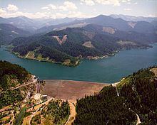
Hills Creek Dam is a dam about 4 miles (6.4 km) southwest of Oakridge in Lane County, Oregon, United States. It impounds Hills Creek Reservoir, which has a surface area of 2,735 acres (1,107 ha) and a shoreline of roughly 44 miles (71 km), on the Middle Fork Willamette River.
Map of Hills Creek Dam, Oakridge, OR 97463, USA
Constructed in 1961 by the United States Army Corps of Engineers (USACE), the dam's purpose is primarily water storage and flood control, and secondarily for recreation, wildlife and waterfowl conservation, and hydropower generation. The earthen dam has a concrete spillway, stands 304 feet (93 m) high, and impounds 355,500 acre feet (438,500,000 m3) of water. There are two hydropower-generating units capable of producing a total of 30 megawatts.
The dam is one of 13 USACE projects in the Willamette Valley, including two others further downstream on the Middle Fork Willamette, Lookout Point Lake and Dexter Reservoir.