
Country United States Time zone Pacific (UTC-8) Elevation 378 m Population 3,196 (2013) | Incorporated 1912 Area code(s) 458 and 541 Zip code 97463 Local time Tuesday 5:09 PM | |
 | ||
Weather 17°C, Wind S at 10 km/h, 41% Humidity Area 5.698 km² (5.439 km² Land / 26 ha Water) | ||
Dashcam hwy 58 through oakridge oregon and back
Oakridge is a city in Lane County, Oregon, United States. The population was 3,205 as of the 2010 census. It is located east of Westfir on Oregon Route 58, about 40 miles (64 km) east of Eugene and 150 miles (240 km) southeast of Portland. Surrounded by the Willamette National Forest and the Cascade Range, Oakridge is popular with outdoor enthusiasts for its hiking, mountain biking, wildflowers, fly fishing, birding, watersports, and nearby Willamette Pass Resort.
Contents
- Dashcam hwy 58 through oakridge oregon and back
- Map of Oakridge OR USA
- Mountain biking in oakridge oregon travel guide
- History
- Geography
- Climate
- Demographics
- Economy
- Land
- Rail
- Bus
- Air
- Ports
- Education
- Notable people
- References
Map of Oakridge, OR, USA
The city was originally a community called "Hazeldell", and its post office was established on July 26, 1888. When a station on the Southern Pacific Railroad opened in May 1912, it was named "Oak Ridge" by a railroad executive for the surrounding topography, and on July 19 of that year the name was changed to "Oakridge".
The economy of Oakridge and nearby Westfir has been centered on the railroad, the logging industry, and recreation. In the 20th century, there were two sawmills that processed logs from nearby timberland—an Oakridge mill owned by the Pope and Talbot Lumber Company and an Edward Hines mill in Westfir. Both of the mills had closed by 1985, and the local economy declined. Since then it has been slowly rebounding, with a new general store opening in 2010, a bakery in 2011, and a brewery and mercantile.
Mountain biking in oakridge oregon travel guide
History
The area now known as Oakridge was first explored in 1852 as a possible route for pioneers coming from Central Oregon to the Willamette Valley. A post office was named "Hazeldell" in 1888, and the place's name later changed to "Big Prairie", and then "Oak Ridge". In 1912, a new community was formed and officially named Oakridge. Since its beginnings as a mountain ranch, Oakridge has been a railroad boomtown, a lumberjacks' haven, and an outdoor enthusiast's destination.
The early boom for Oakridge can be attributed to the Southern Pacific Railroad. By 1910, work had already begun on Tunnel 22, a short route connecting Oakridge to the area now known as Westfir. Oakridge was a station on Southern Pacific's Cascade subdivision, a line that goes over Willamette Pass via the Natron Cutoff that was built in 1926, and the railroad played an integral part of the economy and lifestyle in Oakridge. The Union Pacific Railroad still operates the rails and trains are a common sight in Oakridge.
On July 2, 1946, the Pope and Talbot Lumber Company purchased timberland near Oakridge. By 1948, the company had built a large sawmill and had begun a massive timber logging operation. While the railroad and Westfir's Hines sawmill began to slow down, the Pope and Talbot mill expanded and eventually employed more than 500 people. The combined economic base of the railroad and sawmills accounted for the population growth of the 1960s and 1970s, when the community of Willamette City was consolidated into Oakridge. However, in 1978, the Hines mill in Westfir closed, and by 1985 the Pope and Talbot Mill had laid off all of its workers. The City of Oakridge now owns the property that formerly housed the Pope and Talbot sawmill.
Geography
Oakridge sits at an elevation ranging from 1,200 to 1,600 feet (370 to 490 m) above sea level. According to the United States Census Bureau, the city has a total area of 2.20 square miles (5.70 km2), of which 2.10 square miles (5.44 km2) is land and 0.10 square miles (0.26 km2) is water.
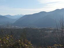
Oakridge lies in a small valley in the foothills of the Cascade Range and is completely surrounded by the Willamette National Forest. Five streams are located in and around Oakridge; they are Salmon Creek, Salt Creek, Hills Creek, and the Middle and North forks of the Willamette River, the latter of which has been designated Wild and Scenic. Diamond Peak, a shield volcano located in the nearby Diamond Peak Wilderness to the southeast, can be seen from various spots in and around Oakridge. Waldo Lake, known as one of the purest lakes in the world, and Salt Creek Falls, one of the largest waterfalls in Oregon, are located about 20 miles (32 km) east of town.
Climate
This region experiences warm (but not hot) and dry summers, with no average monthly temperatures above 71.6 °F (22.0 °C). According to the Köppen Climate Classification system, Oakridge has a warm-summer Mediterranean climate, abbreviated "Csb" on climate maps.
Demographics
As of the census of 2010, there were 3,205 people (up from 3,148 people at the 2000 census), 1,437 households, and 849 families residing in the city. The population density was about 1,526 inhabitants per square mile (589.2/km2). There were 1,605 housing units at an average density of about 764 per square mile (295.0/km2). The racial makeup of the city was about 91% White, 1% African American, 1.8% Native American, 0.6% Asian, 1.5% from other races, and 4.5% from two or more races. Hispanic or Latino of any race were 5.4% of the population.
There were 1,437 households of which about 24% had children under the age of 18 living with them, about 42% were married couples living together, about 11% had a female householder with no husband present, about 6% had a male householder with no wife present, and about 41% were non-families. About 34% of all households were made up of individuals and about 16% had someone living alone who was 65 years of age or older. The average household size was about 2.2 and the average family size was about 2.8.
The median age in the city was about 48 years. Twenty percent of residents were under the age of 18; about 7% were between the ages of 18 and 24; about 19% were from 25 to 44; 32% were from 45 to 64; and about 23% were 65 years of age or older. The gender makeup of the city was 50.2% male and 49.8% female.
Economy
The Pope and Talbot mill closed in 1992, leaving the community without a major employer. Following the closure, many residents struggled to find employment, working low-paying service jobs in the community or commuting to Eugene. The town's two largest employers continue to be the Oakridge School District and the United States Forest Service. However, in recent years there has been a cultural and economic revival centered on the outdoor recreational activities and local artists and craftspeople in the Oakridge area. Many new small businesses have opened, including a bicycle shop/ski shop/mercantile, an outdoor guide service, a microbrewery, and a bakery. The Uptown business district has formed the Uptown Business Revitalization Association (UBRA) and has worked to attract new businesses to the district. In 2016, a craft distillery and tasting room opened. While there is still a scarcity of local employment, Oakridge is creating new businesses and jobs 20 years after the closure of the lumber mill.
Land
State Highway 58, a designated freight route, serves as a major connection between Highway 97 and Interstate 5. Running east-west, Highway 58 links the Willamette Valley with Central Oregon while crossing through the Willamette National Forest and Cascade Range.
Rail
Union Pacific Railroad's main north/south line in the western two-thirds of the United States, with cargo shipping services, runs through Oakridge. Amtrak shares the rail line and provides passenger train service to nationwide destinations from Eugene.
Bus
Lane Transit District's Diamond Express runs three trips inbound and outbound on weekdays to the Eugene/Springfield area.
Air
Oakridge State Airport is a public airport located one mile west of Oakridge. Eugene Airport, located 45 miles (72 km) west, is the closest regional terminal providing passenger and cargo air services with access to all world markets.
Ports
The closest International Shipping Ports to Oakridge are the Port of Coos Bay, located 145 miles (233 km) to the west in Coos Bay, and the Port of Portland, located 149 miles (240 km) to the north in Portland.
Education
The Oakridge School District consists of two schools and serves the children of Oakridge, Westfir, and outlying areas including High Prairie.
In 2008, Oakridge High School was recognized as one of the best high schools in America by U.S. News & World Report.
The University of Oregon and Lane Community College are located 40 miles (64 km) to the west.
The Oakridge Public Library was built at 48318 E. First St., next to the city hall, in 2012. It was paid for with a federal grant of $800,000 and replaces a smaller library that was located in the city hall building.