
Opening date 1953 Opened 1953 Surface area 17.64 km² | Operator(s) Cenwp Height 84 m Length 968 m Total capacity 589.2 million m³ | |
 | ||
Catchment area 991 square miles (2,570 km) Similar Hills Creek Dam, Cougar Dam, Foster Dam, Detroit Dam, Big Cliff Dam | ||
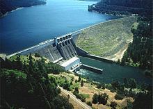
Lookout Point Dam is an earth-type dam on the Middle Fork Willamette River in the U.S. state of Oregon. It is located in Lane County. Its reservoir is called Lookout Point Lake. The dam's primary purpose is flood control, with secondary purposes of power generation, recreation, and irrigation.
Map of Lookout Point Dam, Lowell, OR 97452, USA
References
Lookout Point Dam Wikipedia(Text) CC BY-SA