
Country Austria Postal code 2532 Elevation 312 m Local time Sunday 8:00 AM | Time zone CET (UTC+1) Area code 02258 Population 1,490 (1 Apr 2009) | |
 | ||
Weather 6°C, Wind W at 10 km/h, 91% Humidity University Philosophisch-Theologische Hochschule Benedikt XVI. | ||
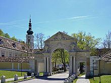
Heiligenkreuz is a municipality in the district of Baden, in the Austrian state of Lower Austria. It is known for the Cistercian monastery of Heiligenkreuz Abbey, the associated papal college Benedict XVI and the Catholic Leopoldinum seminary.
Contents
Map of Heiligenkreuz, Austria
Geography
The municipality is located within the Vienna Woods (Wienerwald) mountain range in the southwest of the Austrian capital Vienna. It is part of the Lower Austrian Industrieviertel region. Heiligenkreuz is a stop on the old Via Sacra from Vienna to Mariazell in Styria. The local economy largely depends on tourism and forestry.
The municipal area comprises the cadastral communities of Heiligenkreuz and Siegenfeld. In the southeast it borders on the district capital Baden.
History
The village of Siegenfeld in the March of Austria possibly arose around 1040. In 1133 the Babenberg margrave Leopold III established the Heiligenkreuz monastery in the sparsely settled area. Another nearby village, mentioned as Muchersdorf in a 1136 deed, later became abandoned.
Over the centuries, a small settlement grew outside the monastery walls, which was incorporated as the present-day municipality in 1849.
Politics
Seats in the municipal assembly (Gemeinderat) as of 2010 local elections: