
Basin countries United Kingdom | Primary inflows Surface elevation 427 m | |
 | ||
Similar Gray Crag, Lake District, Angletarn Pikes, Brock Crags, High Street | ||
Hayeswater is a small lake within the Lake District of Cumbria, England.
Map of Hayeswater Reservoir, Penrith, UK
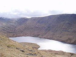
The lake is situated about a mile (1.6 km) SE of the hamlet of Hartsop in the Patterdale Valley. It nestles between The Knott to its west and Gray Crag to the east and it is at an altitude of almost 1,400 feet (425 m). The lake is natural but was dammed in 1908 to provide a reservoir serving the Cumbrian town of Penrith. It is fed from the south by Hayeswater Gill, which rises close to the route of the Roman High Street and continues to Cow Bridge where it joins the outlet stream from Brothers Water.
It had not been used as a reservoir since 2005 and United Utilities removed the dam and restored it to a mountain tarn in the summer of 2014. A new footbridge over Hayeswater Beck was also constructed 250 yards downstream from the tarn outlet channel.