
Primary inflows Basin countries United States Max. width 0.25 mi (0.40 km) Surface elevation 402 m Mean depth 4.57 m | Max. length 0.78 mi (1.26 km) Max depth 12 m Area 56 ha Length 1.26 km | |
 | ||
Similar Thorndike Pond, Contoocook Lake, Dublin Pond, Powder Mill Pond, Locke Lake | ||
Harrisville pond harrisville nh
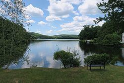
Harrisville Pond is a 138-acre (0.56 km2) water body located in Cheshire County in southwestern New Hampshire, United States, in the town of Harrisville. It is one of many lakes and ponds along Nubanusit Brook, a tributary of the Contoocook River. Water from Nubanusit Lake flows via the Great Meadows into the pond on the north side and out of the pond at two dams on the south side. One dam allows the level of the pond to be raised or lowered and also adjusts the flow through the mills that span that part of the outlet, while the other dam is made of large stones and sandbags. The village of Harrisville is located at the outlet of the pond.
Contents
- Harrisville pond harrisville nh
- Map of Harrisville Pond Harrisville NH 03450 USA
- Moon over harrisville pond new jersey
- References
Map of Harrisville Pond, Harrisville, NH 03450, USA
The pond is warm water and contains largemouth and smallmouth bass, Eastern chain pickerel, brown bullhead, black crappie and bluegill.