
Elevation 5,142 m | Easiest route Arin Bandipore Prominence 1,462 m | |
 | ||
Similar Kolahoi Peak, Apharwat Peak, Machoi Peak, Nun Kun, Tatakooti Peak | ||
Harmukh (also known as Mount Haramukh or Harmukh mountain) is a mountain with a peak elevation of 5,142 metres (16,870 ft), in Ganderbal district of Jammu and Kashmir. Harmukh is part of the Himalaya Range, and is located between Nallah Sindh in the south and Kishanganga Neelum River in the north, rising above Gangabal Lake in the vicinity of Kashmir valley. It is mostly climbed from the northwestern side of Arin Bandipore.
Contents
- Map of Haramukh Forest Block 193502
- Religious beliefs
- Geographical setting
- Climbing history
- Climbing routes
- References
Map of Haramukh, Forest Block 193502
Religious beliefs
Harmukh, with Gangbal Lake at its foot, is considered a sacred mountain by Hindus. According to kashmiri hindu theology, Harmukh is the abode of Lord Shiva. According to the legend of "Hurmukhuk Gosoni"
Geographical setting
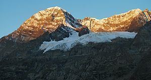
Harmukh lies in the northwestern Himalayan Range. The Karakoram Range borders it on the north and the Kashmir Valley on the south. Melt waters from glaciers form Gangabal Lake which lies at its foot to the north east side and contribute significantly to the regional fresh-water supply, supporting irrigation through Nallah Sindh. This Himalayan Range lies along the southern edge of the Eurasian tectonic plate and is made up of ancient sedimentary rocks (more than 390 million years old). Those strata were folded and thrust-faulted, and granite masses were intruded, when the Indian plate collided with Eurasia, beginning more than 100 million years ago. Harmukh means same on all sides. It is notable for its local relief as it is a consistently steep pyramid, dropping sharply to the east and south, with the eastern slope the steepest.
Climbing history
Harmukh was first climbed by members of the Great Trigonometric Survey led by Thomas Montgomerie in 1856. Montgomerie made the first survey of the Karakoram some 210 km (130 miles) to the north, and sketched the two most prominent peaks, labelling them K1 and K2. Harmukh was later climbed by many other climbers. Most Recently the Haramukh peak was climbed by a local group of climbers from Alpine Adventurers on September 20th 2015. This was the first successful ascent to the eastern peak after nearly 3 decades.
The policy of the Great Trigonometric Survey was to use local names for mountains wherever possible and K1 was found to be known locally as Masherbrum. K2, however, appeared not to have acquired a local name, possibly due to its remoteness. The mountain is not visible from Askole, the last village to the south, or from the nearest habitation to the north, and is only fleetingly glimpsed from the end of the Baltoro Glacier, beyond which few local people would have ventured. Therefore, Harmukh is the mountain from which the world's second-highest mountain peak, K2, was discovered and the name given it by the Survey, K2, continues to be used.
Climbing routes
The easiest route among the different routes of Harmukh is via Arin Bandipore, 47 km motorable road from Srinagar to Arin and 18 kilometers of high altitude alpine tract leads to the base of Harmukh. Another track leads from Naranag to the base of Harmukh at Gangabal Lake, but it is a steep climb at some places.