
Type oligotrophic lake Basin countries India Surface elevation 3,575 m Length 2.5 km | Primary inflows Frozen November to April Max width 1,000 m Outflow location Sind River, Nundkol Lake | |
 | ||
Primary outflows Nundkol Lake which drains into Sind River Max. length 2.7 kilometres (1.7 mi) | ||
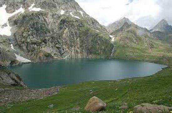
The Gangbal Lake (Urdu: ﮔﻨﮕﺒﻞ ﺟﮭﻴﻞ, Hindi: गंगाबल झील), also called Gangbal Lake, is a lake situated at the foothills of Mount Haramukh (the highest mountain peak in the vicinity of Kashmir valley) in Ganderbal district, north of Srinagar city in the state of Jammu and Kashmir, India. It is an alpine high altitude oligotrophic lake, home to many species of fish, including the brown trout.
Contents
Map of Gangabal, Forest Block 193502
The lake has a maximum length of two and a half kilometres and maximum width of one kilometre. It is fed by precipitation, glaciers and springs. The lake water outflows to a nearby Nundkol Lake and then via Wangath nallah to Sind River.
Access
The Gangbal lake is approached from Srinagar 45 kilometres by road via Ganderbal up to Naranag and then a trek of 15 kilometres upslopes leads to the lake, which can be covered by a horse ride or by foot. The gujjar shepherds can be seen during the trek with their flocks of sheep and goats. Another trek (25 kilometres long) leads to the lake site from Sonamarg via the Vishansar Lake crossing three mountain passes Nichnai pass, Gadsar pass and Zajibal pass of an average elevation of 4100 meteres. It can also be accessed through a trek from Bandipore via Arin.