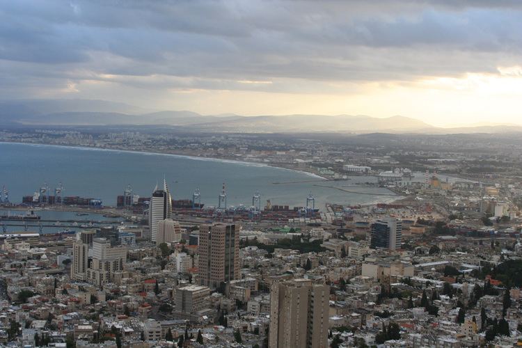
The Haifa metropolitan area (Hebrew: מטרופולין חיפה) is a metropolitan area including areas from both the Haifa and the Northern districts of Israel. It is located along the Israeli Mediterranean coastline. The Haifa metropolitan area is the third largest metropolitan area in Israel, with an estimated population of almost 1 million.
Israel Central Bureau of Statistics divides the Haifa metropolitan area into three:
Notes
1 The population of "Jews and others" includes Jews, non-Arab Christians and those not classified by religion.2 The core area includes the city of Haifa.3 The inner ring consists of the Haifa District and includes the cities Kiryat Bialik, Kiryat Yam, Kiryat Motzkin, Kiryat Ata, Tirat Carmel and Nesher, as well as a multitude of smaller towns (local councils).4 The outer ring includes the cities Tamra, Karmiel and Nahariya, as well as many smaller towns (local councils).Downtown Haifa - the central business district of Haifa. In this area has the port of Haifa, many shops and some beaches.Bay area - Haifa - between Haifa and the Krayot. In this area has some malls and business. This area is also important transport center with buses to Haifa and north the country and with trains to central and south the country.Matam park - Haifa - Hi-tech park in south of the city. In this park has the offices of Google, Microsoft and Yahoo! of Israel. Matam also has the IEC Tower, one of the tallest in the city.Carmel Center neighborhood (Merkaz HaKarmel) - Haifa - shops and restaurant.Coastal strip of Haifa - from the downtown until Matam park.HaGaaton boulevard - Nahariya - The main street of the city from the beaches to Highway 4. The street has shops, restaurants, some hotels and the railway and bus stations.Coastal strip of Nahariya - some restaurants and one of northmost coastal strips in the country.Industrial park of Karmiel - in the east of the city.Haifa
Haifa MallGrand canyonLev HaMifratz MallHorev centerKrayot
HaKiryonAzrieli Kiryat AtaNahariya
Nahariya MallKanyon HaTzafon (The north mall)Karmiel
Hotzot Karmiel MallAkko
Azrieli AkkoThe bus company Egged turn on many lines within Haifa city and some lines connecting Haifa with other cities in the metropolitan area. Israel's national highway network connecting Haifa with other metropolitan areas, far cities and her suburbs. Haifa Airport is airport with domestics flights to Eilat and flights to Jordan. Israel Railways turn on inter city line to other cities in the country and one commuter line from Haifa to northern suburbs. In the future, plans more two new lines to eastern suburbs.
The major highways in the Haifa metropolitan area include Area are:
Highway 2 - connects Haifa with Tel Aviv.Highway 4 - connects all Israeli coastal plain cities and pass via Haifa city.Highway 75 - connects Haifa with Lower Galilee via Jezreel Valley.Highway 70 - connects Carmel plain with Western Galilee. most part of this highway without the metropolitan area.Highway 85 - connects Akko with Upper Galilee.Highway 79 - connects Krayot area with Lower Galilee.