
Coordinates (East end) (West end) Length 1,347 km (837 mi) Permits 3 required | Type Track | |
 | ||
East end Amata Road,Victory Downs Homestead Regions | ||
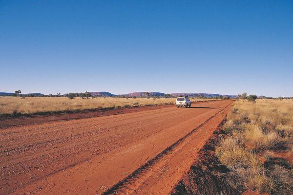
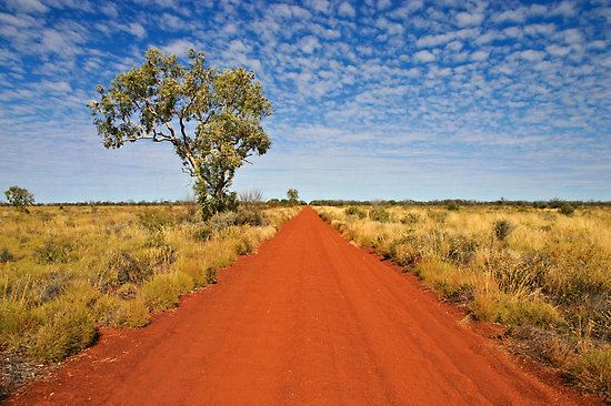
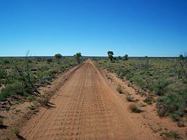
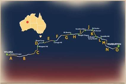
The Gunbarrel Highway is an isolated desert track in the Northern Territory, South Australia and Western Australia. It consists of about 1,350 km (840 mi) of washaways, heavy corrugations, stone, sand and flood plains. The Gunbarrel Highway connects Victory Downs in the Northern Territory to Carnegie Station in Western Australia. Some sources incorrectly show the highway extending west to Wiluna. The road was built as part of Australia's role in the weapons research establishment called Woomera which included Emu Field and Maralinga, both atomic bomb testing sites. The name comes from Len Beadell's Gunbarrel Road Construction Party so named as his intention was to build roads as straight as a gunbarrel.
Contents
- Tour coach on the muddy gunbarrel highway in outback australia
- History
- First stage
- Second stage
- Third stage
- Fourth stage
- Conditions
- References
Tour coach on the muddy gunbarrel highway in outback australia
History
There were three main reasons for the construction of the Gunbarrel Highway. The first was to provide access for a future meteorological station which was needed to forecast upper winds prior to the testing of atomic weapons in South Australia. The second was for instrumentation along the centre-line of fire for rockets launched from Woomera, and the third was to allow surveyors from the National Mapping Council to continue the geodesic survey of little known areas of outback Australia. A consequence of the construction was the completion of the first east-west road link across the centre of Australia.
First stage
The road was built in four stages beginning in 1955. In early November, the Gunbarrel Road Construction Party (GRCP) assembled near Coober Pedy in South Australia, half coming from Adelaide together with a bulldozer, and half with a grader from Maralinga, led by Len Beadell. The starting point was Victory Downs homestead just over the border with the Northern Territory, and 24 kilometres west of the Stuart Highway. Work began on 13 November 1955, and continued westward to Mulga Park. An interruption occurred after about 35 km when the grader's blade mounting bolts were snapped after hitting a submerged Mulga tree root. Beadell made a hurried return trip to Alice Springs for parts. The road reached Mulga Park on 2 December, where construction ceased for the year, as the bulldozer's starting pilot motor had failed. Beadell continued ahead on a ground reconnaissance, then on 7 December made an aerial survey which departed from a natural airstrip in the Mount Davies vicinity, and flew towards the Rawlinson Ranges where the future weather station was to be located. With the knowledge gained, Beadell led a ground party of four Land Rovers to the site where a stone cairn was built on 12 December. The site was named Giles after Ernest Giles (the first European to explore the area in 1874). Beadell's Land Rover suffered a broken rear axle during the return towards Mount Davies, so an axle was borrowed from one of the other vehicles which was left behind to be recovered the following year.
Second stage
In February 1956 the second stage continued from Mulga Park to the Musgrave Ranges, then in March via the Mann Ranges and Tomkinson Ranges to Giles where the party arrived on 29 March. Beadell had hoped to take the road via Surveyor Generals Corner, but it was too rocky for road building. The first priority in establishing the weather station was to find water, and a boring plant was obtained from the nearest railhead 800 km to the east. It was slowly towed to Giles by the grader, and on the fourth drilling attempt, suitable drinking water was discovered. Work on the Giles establishment continued throughout April and May, which included laying out the airstrip. In June Beadell and the GRCP were called away to begin work on the Mount Davies road.
In 1957, no further work took place on the Gunbarrel Highway, however Beadell continued work at Giles during the early months.
Third stage
The third stage of the highway began with a solo reconnaissance by Beadell from Giles to Warburton on 12 March 1958, when the weather was still very hot. In his book Too Long in the Bush, Beadell described the forbidding conditions in a chapter which he called "An Unshared Nightmare". Daytime temperatures were between 40 and 45 °C (104 and 113 °F), which resulted in an overheating engine and fuel vaporisation. The extreme heat melted plastic parts of his instrument panel and radio transmitter, and loosened nails in his boots which caused the heels to fall off. He lost his appetite and drank hot water only. His course took him along the southern edge of the Rawlinson Range towards Lake Christopher, then southwards through the eastern edge of the Gibson Desert. After battling through a series of jumbled sand ridges, and having three flat tyres, he found that his water supply was almost exhausted. When clear of the ridges, some rocky hills led to his discovery of a small pool of water in a creek run-off, which saved his life. He arrived at Warburton and rested for three days prior to the return journey to Giles via a different route.
After a delay caused by rain, building of the next section started on 22 March from Giles, keeping to the north and west of his earlier reconnaissance route, avoiding known obstacles. The road passed close by the position where it was estimated that Gibson had perished, then turned south towards Warburton, which was reached by early May. While at Warburton, Beadell and his team built a new airstrip much closer to the mission settlement.
Fourth stage
Building of the fourth stage did not commence until an altered arrangement for the survey took place. On this occasion, Beadell was joined by an additional surveyor Major H. A. "Bill" Johnson, with whom he had served in the Army Survey Corps. Each had a Land Rover in the advance party, and they were followed by two other Land Rovers and a supply truck. The second group included an officer from headquarters in Woomera, and an aboriginal affairs officer. Meanwhile, most of the GRCP returned to Giles, leaving the heavy equipment at a future turn-off (Jackie Junction) 69 km north of Warburton. The survey from the turn-off west towards Carnegie Station took place from 14–28 May during which a mountain was found. It was subsequently named Mount Beadell in honour of Beadell.
Construction of the final section began at Jackie Junction on 3 September, was abeam Mount Beadell on the 25 September, Everard Junction (with the Gary Highway) around 15 October, and reached Carnegie Station on 15 November 1958, just over three years from when the Gunbarrel Highway was begun. The length of new road built from Victory Downs was 1347 km.
Conditions
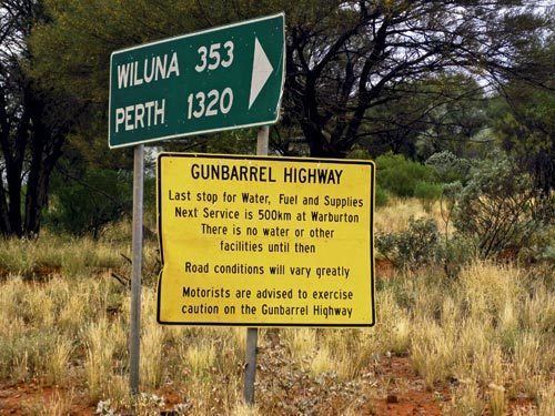
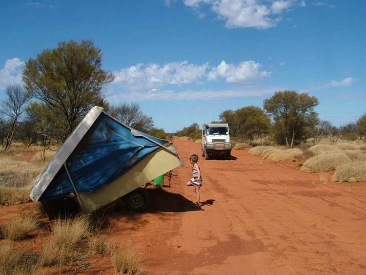
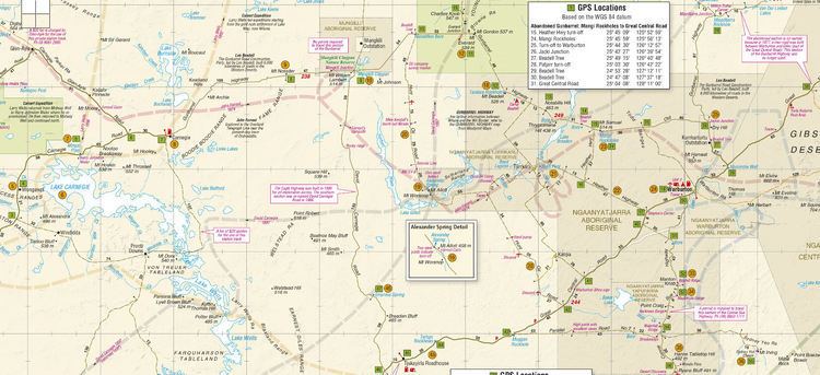
By any standard, this is a long and tough haul through very remote territory. Its isolation requires travellers to be totally self-sufficient with water, food and fuel (the longest distance between fuel outlets is 489 kilometres (304 mi), between Warburton and Carnegie Station.) Part of the road between Jackie Junction and Warakurna (near Giles) is now known as the Old Gunbarrel Highway, and is no longer maintained due to the construction of the more direct route, the Great Central Road.
The route passes directly into Aboriginal reserves and it is a legal requirement for travellers to hold a valid transit permit at the time of travel. Three permits are required and they are available from the Department of Indigenous Affairs. The permits are free.