
Type Road Route number(s) State Route 51 | Length 10.09 km (6.3 mi) | |
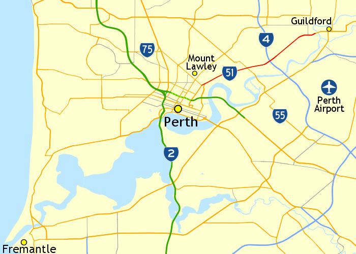 | ||
Guildford Road is a major road in Perth, Western Australia, linking the inner-city suburb of Mount Lawley with Guildford in the north-east. The ten-kilometre-long (6.2 mi) road runs mostly parallel to the Swan River, on its northern side, and is part of State Route 51, which runs between Perth's CBD and Midvale. Guildford Road is maintained and controlled by Main Roads Western Australia, which uses the internal designation "H026 Guildford Road" for Guildford Road, as well as Bridge Street and James Street in Guildford. In the 1930s, the name Great Eastern Highway was coined to describe the road, but was actually used for the road on the other side of the Swan River.
Contents
- Map of Guildford Rd Western Australia Australia
- Route description
- Origins
- Naming
- Upgrades and improvements
- Major intersection
- References
Map of Guildford Rd, Western Australia, Australia
Route description
Guildford Road begins at a three-way junction with Lord Street and Walcott Street in Mount Lawley. It runs in a north-easterly direction, passing under the Midland railway line at the Mount Lawley Subway, and continuing through the residential areas of Maylands and Bayswater After a folded diamond interchange with Tonkin Highway, the road follows the Midland railway line to Bassendean. A short distance after the intersection with West Road and Bassendean Oval, the road narrows to a single lane in each direction, and Guildford Road becomes Bridge Street. Bridge Street crosses the Swan River, connecting to Guildford's main road, James Street.
Origins
A road to Guildford was constructed in the 1830s, shortly after the founding of the Swan River Colony. Lieutenant Dale was appointed, and paid a salary, to construct a road and some small bridges. At a special meeting of the Agricultural Society on 8 April 1834, the quality was criticised as "the work of a rough carpenter", as was the fact that works finished at the road leading to the private residence of the Colonial Secretary. The following week the comments regarding the extent of the works was described as erroneous, as there was some distance from the completed section to the branch road, and that "workmen were taken off the road at the express recommendation of the Agriculturists, to enable them to procure labourers during the harvest-time".
By September 1840, the road was in a "shameful state" of disrepair, with many owners of horses for hire refusing to let their animals travel on the road. The local newspaper, The Perth Gazette and Western Australian Journal, speculated that the reason for the neglect was the road on the southern side of the Swan River would soon be open, and warned that until then, the cost of public injuries would likely be ten times the cost of necessary repairs.
Naming
The name Great Eastern Highway was coined by the Perth Road Board in December 1933. It was suggested for the Perth to Guildford road on the north side of the Swan River (modern-day Guildford Road), as an alternative to the Bassendean Road Board's proposal, Perth Road. In February 1934, the Bassendean Road Board agreed to the name, as Perth Road would be too general, and the road was considered the main artery serving eastern districts, all the way through to Kalgoorlie. Other local governments in the area considered the issue over the next few months. The Bayswater Road Board and Greenmount Road Board were in favour of the idea, but Guildford Road Board was opposed, as several local road names would be lost. Greenmount, and public advertising, thereafter referred to the road as Great Eastern Highway, and the council wrote to the Main Roads Department, requesting the name change be gazetted. This prompted Main Roads to write to other local governments, advising of the request and soliciting their views. The Mundaring Road Board and Kellerberrin Road Board were supportive, while the Kalgoorlie Road Board suggested Great Eastern Goldfields Highway. The Kalgoorlie Municipal Council agreed that the road should be known as a highway, but thought the name was inadequate for a road that only connected Midland Junction with Coolgardie. The Midland Junction Municipal Council opposed the renaming, citing "sentimental and practical reasons for the continuance of the use of the old name".
In August 1934, the Bassendean Road Board applied to Lands Department to change the portion of the Perth–Guildford road within its district to Great Eastern Highway. The department refused the request, reasoning that most traffic bound for Midland used the Causeway and travelled on the south side of the Swan River, and that therefore the Perth–Guildford road should not be part of the main highway. Despite this setback, the Perth Road Board organised a local government conference to consider renaming the road from Perth to Guildford. The issue was considered important, as losing the name to the south side of the river would divert traffic away from the old established centres to the north. The straightening of dangerous bends and the replacement of an old bridge between Bassendean and Guildford were also to be considered. The conference, held on 7 September 1934, was attended by representatives of the Perth, Bayswater, Bassendean, and Guildford road boards, and the Midland Junction Council. Guildford and Midland Junction were still opposed to the renaming, but the others were supportive. Motions that passed included submitting a rename proposal to the state government, urging the government to construct a new bridge at Bassendean, and approaching the government to have the road declared a main road.
In November 1934, the state government Land Council contacted the local governments on the south side of the Swan River, asking them to rename the roads that make up the Causeway–Midland route as Great Eastern Highway. Both the Perth City Council and Belmont Park Road Board agreed to the request. This created a "peculiar situation", as described by the Royal Automobile Club, with roads both north and south of the Swan River proposed to be renamed as Great Eastern Highway. Despite the name change not being official, some residents along the road through Belmont started describing their properties as located on Great Eastern Highway.
Another conference of the local governments north of the river was held in December 1934. They decided to continue to pursue renaming the Perth–Guildford road to Great Eastern Highway, and having it gazetting as a main road. A letter from Commissioner of Main Roads had stated that the road through Belmont was considered the principle highway to the eastern states. He therefore recommended that if the name Great Eastern Highway were to be applied west of Midland Junction, it should be to that road, as the road through Bassendean was not considered a main road. Traffic counts collected by the Bassendean Road Board, however, showed that the north of river route, through Bassendean, carried more traffic in both directions than the southern route, through Belmont – 54% compared to 46%. The northern route was also shorter by about two miles (3.2 km), and considered by the local governments to be the "natural entrance to the city", only crossing the Swan River once and not again at the Causeway.
On 8 January 1935, representatives from the local governments north of the river urged Minister for Lands, Michael Troy, to rename the Perth–Guildford road through those areas as Great Eastern Highway. Despite the route being shorter and carrying more traffic, he refused. He said that it was not gazetted as main road, and a previous decision to rename the road through Belmont as Great Eastern Highway was made after considering the facts, and at the request of the Main Roads Board. There was resentment and an objection over the name being "pinched" from the Perth Road Board. The minister disregarded the objection. He advised the representatives to see the Minister for Works to get the road declared a main road, and then approach him with new name. This resolved Great Eastern Highway's route, with the local governments north of the river pursuing other names such as Main Highway.
Upgrades and improvements
The Mount Lawley Subway had two main issues in its history, flooding during heavy rains and "narrowness" created an ongoing issue until its widening. The section near Bassendean has also been improved. As late as 1968, Guildford Road was aligned through Bassendean, curving multiple times. It has since been realigned to the northern edge of the town centre, with the previous alignment now named Old Perth Road. Old Perth Road has existed as a distinct road since at least 1992.
Major intersection
Guildford Road has the following major junctions: