
 | ||
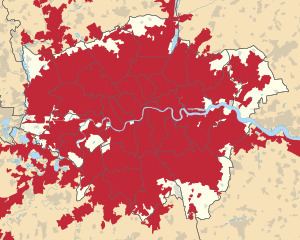
The Greater London Built-up Area, or Greater London Urban Area, is a conurbation in south-east England that constitutes the continuous urban area of London and includes surrounding adjacent urban towns as defined by the Office for National Statistics. It is the largest urban area in the United Kingdom with a population of 9,787,426 in 2011.
Contents
Overview
The Greater London Built-up or Urban Area had a population of 9,787,426 and occupied an area of 1,737.9 square kilometres (671.0 sq mi) at the time of the 2011 census.
It includes most of Greater London, omitting most of its woodland, as well as small, buffered districts, the Lee Valley Park and the two largest sewage treatment works serving London by the River Thames. Outside the administrative boundary it includes contiguous suburban settlements and a few densely populated outliers connected to it by ribbon development. Its outer boundary is constrained by the Metropolitan Green Belt and it is therefore much smaller than the wider metropolitan area of London.
As a selective grouping of relatively low-to-mid density (and some high density) output areas each consisting of roughly 120 households, it can be compared to Greater London which covers 1,572 square kilometres (607 sq mi) and contained 8,173,194 residents at the time of the 2011 census.
The built-up area of London continues beyond the administrative boundary in some places, while stopping short of it in others. For this reason, the density of the Greater London Built-Up Area is 8.3% higher than that of Greater London, the figure for which includes these outlying rural areas (notably in Hillingdon, Enfield, Havering and Bromley). All of both areas is drained ultimately by the River Thames. The area uses around 4 GigaWatts of electricity power.
2011 Census subdivisions
At the time of the 2011 Census, the Office for National Statistics defined the Greater London Urban Area as being made up of the following components:.
Omitted areas
The following areas were considered Built-up areas in the 2011 census but lay outside the Greater London Built-up Area although they lay inside Greater London. All of these areas had populations of less than a thousand except New Addington and Harefield which had populations of 22,280 and 6,573 respectively.
2001 Census subdivisions
At the time of the 2001 Census, the Office for National Statistics defined the Greater London Urban Area as being made up of the following components:
Greater London
Within Greater London there are 33 components corresponding to the City of London and the London boroughs. However, the boundaries are not identical and outlying areas such as Biggin Hill in Bromley are omitted.