
Elevation 5,642 m | ||
 | ||
Length 1,200 km (750 mi) NW-SE Mountains Shkhara, Mount Bazardüzü, Janga, Mount Shahdagh, Dombay‑Ulgen | ||
Greater Caucasus (Azerbaijani: Böyük Qafqaz, Бөјүк Гафгаз, بيوک قافقاز; Georgian: დიდი კავკასიონი, Didi Ǩavǩasioni; Russian: Большой Кавказ, Bol’shoy Kavkaz, sometimes translated as "Caucasus Major", "Big Caucasus" or "Large Caucasus") is the major mountain range of the Caucasus Mountains.
Contents
- Map of Greater Caucasus Kabardino Balkaria Russia 361813
- EuropeAsia boundary
- Watershed
- Peaks
- Passes
- References
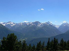
Map of Greater Caucasus, Kabardino-Balkaria, Russia, 361813
The range stretches for about 1,200 kilometres (750 mi) from west-northwest to east-southeast, between the Taman Peninsula of the Black Sea to the Absheron Peninsula of the Caspian Sea: from the Western Caucasus in the vicinity of Sochi on the northeastern shore of the Black Sea and reaching nearly to Baku on the Caspian.
The range is traditionally separated into three parts:
In the wetter Western Caucasus, the mountains are heavily forested (deciduous forest up to 1,500 metres (4,900 ft), coniferous forest up to 2,500 metres (8,200 ft) and alpine meadows above the tree line). In the drier Eastern Caucasus, the mountains are mostly treeless.
Europe—Asia boundary
The watershed of the Caucasus is also considered the boundary between Eastern Europe and Western Asia. The European part north of the watershed is known as Ciscaucasia, the Asiatic part to the south as Transcaucasia, which is dominated by the Lesser Caucasus mountain range and whose western portion converges with Eastern Anatolia.
The border of Russia with Georgia and Azerbaijan runs along the most of the Caucasus' length. The Georgian Military Road (Darial Gorge) and Trans-Caucasus Highway traverse this mountain range at altitudes of up to 3,000 metres (9,800 ft).
Watershed
The watershed of the Caucasus was the border between the Caucasia province of the Russian Empire in the north and the Ottoman Empire and Persia in the south in 1801, until the Russian victory in 1813 and the Treaty of Gulistan which moved the border of the Russian Empire well within Transcaucasia. The border between Russia and Georgia still follows the watershed almost exactly (with the exception of a narrow strip of territory in northern Mtskheta-Mtianeti and northwestern Kakheti where Georgia extends north of the watershed), while Azerbaijan in its northeastern corner has five districts north of the watershed (Davachi, Khachmaz, Qusar, Siazan, Quba).