
Airport type Public / Military Elevation AMSL 1,158 ft / 353 m 5,000 1,524 Elevation 353 m | 5/23 5,000 1,524 Concrete | |
 | ||
Contract fraud at the air traffic control tower grayling army airfield december 19 2012
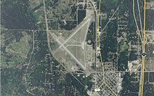
Grayling Army Airfield (ICAO: KGOV, FAA LID: GOV) is a public/military use airport located one nautical mile (1.85 km) northwest of the central business district of Grayling, in Crawford County, Michigan, United States. It is owned by United States Army. The airfield is located 7 miles (11 km) northeast of the main cantonment area of Camp Grayling. It is included in the Federal Aviation Administration (FAA) National Plan of Integrated Airport Systems for 2017–2021, in which it is categorized as a general aviation facility.
Contents
- Contract fraud at the air traffic control tower grayling army airfield december 19 2012
- Contract fraud at the air traffic control tower grayling army airfield april 11 2013
- Facilities
- Runways
- Transit
- References
Grayling AAF covers an area of 923 acres (374 ha) at an elevation of 1,158 feet (353 m) above mean sea level. For the 12-month period ending December 31, 2008, the airport had 4,691 aircraft operations, an average of 10 per day: 63% general aviation and 37% military.
Although most U.S. airports use the same three-letter location identifier for the FAA and IATA, this airport is assigned GOV by the FAA but has no designation from the IATA (which assigned GOV to Gove Airport in Australia).
Contract fraud at the air traffic control tower grayling army airfield april 11 2013
Facilities
The airport is staffed from dawn until dusk. The 29,000-square-foot (2,700 m2) parking area can accommodate fixed-wing aircraft with parking for 100 helicopters, 50 with cement pads with a total of 70 tie downs. The control tower was recently upgraded to a STVS (Small Tower Voice Switch) system with positions in three different locations. There is an 800-square-foot (74 m2) operations building which includes an operations center, flight planning room, safety office, commander's office, and a weather room. Additionally, the airfield contains a 6,400-square-foot (590 m2) maintenance hangar, crash rescue barn and NAVAIDS which include TVOR, NDB, VASI and REIL.
Runways
The airfield consists of two 5000x150-foot runways with 1,200-foot (370 m) overrun and 50-foot (15 m) wide connecting taxiways.
Runway 5/23 and taxiways A/D/E are closed during the winter months, since there is no snow removal on these surfaces.