
- summer (DST) EDT (UTC-4) Zip code 14072 Area code 716 | Area 86.25 km² Local time Saturday 3:06 AM | |
 | ||
- water 5.0 sq mi (13 km), 15.02% Weather 0°C, Wind E at 11 km/h, 57% Humidity Points of interest Fantasy Island, Beaver Island State Park, Buckhorn Island State Park, Grand Island Fun Center, Veterans Park | ||
Silver comet coaster pov martin s fantasy island grand island new york usa
Grand Island is a town located in Erie County, New York, United States. As of the 2010 census, the town's population was 20,374, representing an increase of 9.41% from the 2000 census figure. The town's name derives from the French name La Grande Île, as Grand Island is the largest island in the Niagara River and fourth largest in New York state. The phrase La Grande Île appears on the town seal.
Contents
- Silver comet coaster pov martin s fantasy island grand island new york usa
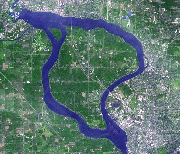
- Map of Grand Island NY USA
- Period before the American Revolution
- Period after the American Revolution
- Geography
- Adjacent cities and towns
- Major highways
- Demographics
- Communities and locations on Grand Island
- Points of interest
- Notable people
- Public schools
- Parochial Schools
- Dining on Grand Island
- References
Map of Grand Island, NY, USA
Over its history, Grand Island has served as home to the Attawandaron Nation and been an acquisition of both French and English colonial pursuits. In 1945, Grand Island was part of a plan to make a new World Peace Capital on the international border between Southern Ontario, Canada, and Western New York. The plan proposed placing the United Nations headquarters on adjacent Navy Island (Ontario), which was considered an ideal location because it lay on the boundary between two peaceful countries. An artist's rendering of the World Peace Capital showed the property with bridges spanning both countries (between Grand Island in the United States and the Canadian mainland). The proposal was turned down in favor of the current U.N. headquarters in New York City.
The town of Grand Island is located in the northwestern corner of Erie County, and on the Canada–US border, although there is no river crossing. It is northwest of Buffalo and is traversed by Interstate 190 and New York State Route 324.
Period before the American Revolution
In the early historical period of the island, French explorers found members of the Neutral Nation of Native Americans, also known as the Attawandaron, living on the island. By 1651, the nearby Seneca Nation had chased off or killed the Neutrals, having also absorbed some of the survivors. The Seneca then used the island for hunting and fishing.
In 1764, as part of the Treaty of Cession after the French and Indian War, the island became part of the British colonies in North America.
Period after the American Revolution
In 1815, New York State purchased Grand Island and other small islands in the Niagara River from the Iroquois nation for $1,000 in hand, and annually, a perpetuity of $500 every June. The treaty was signed by Governor Daniel D. Tompkins, Peter B. Porter, Chief Red Jacket, Falling Boards, Twenty Canoes, Sharp Shins, Man Killer, and others. The Senecas reserved the right to hunt, fish and fowl on the islands.
In 1824, in a precursor to modern Zionism, journalist and Utopian Mordecai Manuel Noah tried to found a Jewish homeland on Grand Island. It would be called Ararat, after Mount Ararat, the Biblical resting place of Noah's Ark. However, the idea failed to attract Noah's fellow Jews, and it never got further than a ceremonial laying of a cornerstone. MacArthur Award-winning cartoonist Ben Katchor fictionalized Noah's scheme for Grand Island in his graphic novel The Jew of New York.
The town of Grand Island was organized in 1852 from part of the town of Tonawanda.
On August 25, 1993, the Seneca Nation commenced an action in the United States District Court for the Western District of New York to reclaim land that allegedly was taken from them without the approval of the United States. The Senecas argued the 1815 transaction with New York State violated the Trade and Intercourse Act of 1790, which stated that no Native American lands were to be sold without the federal government's consent. The Senecas sought the ejection of more than 2,000 property owners on the island. By decision and order dated June 21, 2002, the trial court held the subject lands were ceded to Great Britain in the 1764 treaties of peace and the subject lands were not owned by the Seneca at the time of the 1794 Treaty of Canandaigua. New York state's purchase of them in 1815 was intended to avoid conflict with the Senecas over land it already owned. This decision was appealed, and the United States Court of Appeals for the Second Circuit affirmed the trial court's decision on September 9, 2004. The Senecas then sought review of this decision by the Supreme Court of the United States, which was denied on June 5, 2006.
Geography
According to the United States Census Bureau, the town has a total area of 33.3 square miles (86.2 km2), of which 28.3 square miles (73.2 km2) is land and 5.0 square miles (13.0 km2), or 15.08%, is water.
The Niagara river splits into two parts at the south end of the island and rejoins at the northwest end, about 3 miles (5 km) upstream (east) of Niagara Falls.
The town lies adjacent to the border between Canada and the United States. As there is no direct bridge or ferry connection from the island to Canada, there are no customs or immigration services available. Paired bridges connect the south end of the island to the town of Tonawanda, and another pair of bridges connects the northern end to the city of Niagara Falls in Niagara County. The two sets of bridges carry Interstate 190, a branch of the New York State Thruway (Interstate 90). In addition, New York State Route 324 (Grand Island Boulevard) is conjoined with I-190 at the southern bridges and reaches its western terminus in the northern part of Grand Island.
Adjacent cities and towns
Major highways
Demographics
As of the census of 2000, there were 18,621 people, 6,898 households, and 5,221 families residing in the town. The population density was 653.1 people per square mile (252.2/km²). There were 7,355 housing units at an average density of 257.9 per square mile (99.6/km²). The racial makeup of the town was 95.80% White, 3.17% African American, 0.25% Native American, 1.17% Asian, 0.01% Pacific Islander, 0.25% from other races, and 0.88% from two or more races. Hispanic or Latino of any race were 1.09% of the population.
There were 6,898 households out of which 35.8% had children under the age of 18 living with them, 64.8% were married couples living together, 7.7% had a female householder with no husband present, and 24.3% were non-families. 20.2% of all households were made up of individuals and 7.9% had someone living alone who was 65 years of age or older. The average household size was 2.68 and the average family size was 3.13.
In the town, the population was spread out with 26.7% under the age of 18, 6.5% from 18 to 24, 27.7% from 25 to 44, 27.7% from 45 to 64, and 11.3% who were 65 years of age or older. The median age was 39 years. For every 100 females there were 97.4 males. For every 100 females age 18 and over, there were 94.4 males.
The median income for a household in the town was $60,432, and the median income for a family was $70,521. Males had a median income of $48,457 versus $30,157 for females. The per capita income for the town was $25,816. About 2.4% of families and 3.0% of the population were below the poverty line, including 3.3% of those under age 18 and 5.1% of those age 65 or over.
Communities and locations on Grand Island
Points of interest
Notable people
Public schools
Public schools are under the jurisdiction of the Grand Island Central School District.
Parochial Schools
Dining on Grand Island
Despite its small population, Grand Island contains seven fast food restaurants, six pizzerias, and twelve privately owned dine-in restaurants, many of which are owned by Grand Island residents.