
Population 3,916 (2006) | Area 174 km² | |
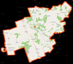 | ||
Gmina Sidra is a rural gmina (administrative district) in Sokółka County, Podlaskie Voivodeship, in north-eastern Poland. Its seat is the village of Sidra, which lies approximately 18 kilometres (11 mi) north of Sokółka and 52 km (32 mi) north of the regional capital Białystok.
Contents
Map of Gmina Sidra, Poland
The gmina covers an area of 173.96 square kilometres (67.2 sq mi), and as of 2006 its total population is 3,916.
Villages
Gmina Sidra contains the villages and settlements of Andrzejewo, Bieniasze, Bierniki, Bierwicha, Chwaszczewo, Dworzysk, Gudebsk, Holiki, Jacowlany, Jakowla, Jałówka, Jałówka-Kolonia, Jurasze, Kalinówka, Kalwińszczyna, Klatka, Kniaziówka, Krzysztoforowo, Kurnatowszczyzna, Ludomirowo, Majewo, Majewo Kościelne, Makowlany, Nowinka, Ogrodniki, Olchowniki, Podsutki, Poganica, Pohorany, Potrubowszczyzna, Putnowce, Racewo, Romanówka, Siderka, Sidra, Siekierka, Słomianka, Śniczany, Staworowo, Stefanowo, Szczerbowo, Szostaki, Wandzin, Władysławowo, Wólka, Zacisze, Zalesie, Zelwa and Zwierżany.
Neighbouring gminas
Gmina Sidra is bordered by the gminas of Dąbrowa Białostocka, Janów, Kuźnica, Nowy Dwór and Sokółka.