
Sovereign state United Kingdom Region East Midlands Area rank 183rd Ceremonial county Derbyshire | Constituent country England Admin. HQ Clowne Area 160.3 km² | |
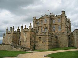 | ||
Time zone Greenwich Mean Time (UTC+0) Points of interest Bolsover Castle, Hardwick Hall, Creswell Crags, Stainsby Mill, Hardwick Old Hall Destinations Alfreton, Bolsover, Pleasley, Whitwell, Pilsley - North Eas | ||
Bolsover is a local government district in Derbyshire, England. The Admin. HQ is Clowne. The district council is a non-constituent partner member of the Sheffield City Region Combined Authority. The population of this district council in the 2011 Census was 75,866.
Contents
Map of Bolsover District, UK
Town and parish councils
There are fourteen town and parish councils within the district.
In addition to the town councils of Old Bolsover and Shirebrook, there are the parish councils of:
Other settlements include Broadmeadows, Hilcote, Langwith, Old Blackwell, Newton, Palterton, Shirebrook and Westhouses.
The current district boundaries date from 1 April 1974, when the urban district of Bolsover was merged with Blackwell Rural District and Clowne Rural District.
Governance
Bolsover District Council is elected every four years, with currently 37 councillors being elected at each election. The Labour party has had a majority on the council since the first election to the council in 1973 and as of the 2015 election the council is composed of the following councillors:-
Local Development Framework
The council is currently in the process of Consulting on its draft Infrastructure and Delivery Plan.