
Length 320 km | Discharge Location: Source Sivalik Hills Cities Sirsa | |
 | ||
Native name घग्गर-हाकरा नदी/ ਘੱਗਰ-ਹਕੜਾ ਨਦੀ Waterbodies | ||
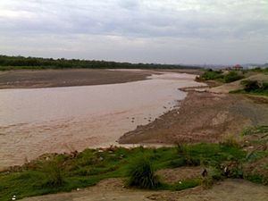
The Ghaggar-Hakra River is an intermittent, endorheic river in India and Pakistan that flows only during the monsoon season. The river is known as Ghaggar before the Ottu barrage and as the Hakra downstream of the barrage.
Contents
- Map of Ghaggar River
- Ghaggar RiverEdit
- TributariesEdit
- Hakra RiverEdit
- PalaeogeographyEdit
- Ancient tributariesEdit
- SutlejEdit
- YamunaEdit
- Association with the Harappan civilizationEdit
- Rig VedaEdit
- Identification with Vedic rivers in recent scholarshipEdit
- References
Map of Ghaggar River
The basin is classified in two parts, Khadir and Bangar, the higher area that is not flooded in rainy season is called Bangar and the lower flood-prone area is called Khadar.
Nineteenth and early 20th century scholars, but also more recent authors, have suggested that the Ghaggar-Hakra might be the defunct remains of the mythological Sarasvati of the Rig Veda. Recent geophysical research does not support this idea. It shows that the Ghaggar-Hakra system was not sourced by the glaciers and snows of the Himalayas, but rather by a system of perennial monsoon-fed rivers. Late Holocene aridification subsequently reduced the Ghaggar-Hakra to the seasonal river it is today.
Ghaggar RiverEdit
The Ghaggar is an intermittent river in India, flowing during the monsoon rains. It originates in the village of Dagshai in the Shivalik Hills of Himachal Pradesh at an elevation of 1,927 metres (6,322 ft) above mean sea level and flows through Punjab and Haryana states into Rajasthan; just southwest of Sirsa, Haryana and by the side of Talwara Lake in Rajasthan.
Dammed at Ottu barrage near Sirsa, Ghaggar feeds two irrigation canals that extend into Rajasthan.
TributariesEdit
The main tributaries of the Ghaggar are the Kaushalya river, Markanda, Sarsuti, Tangri and Chautang.
The Kaushalya river is a tributary of Ghaggar river on the left side of Ghahhar-Hakra, it flows in the Panchkula district of Haryana state of India and confluences with Ghaggar river near Pinjore just downstream of Kaushalya Dam.
The present-day Sarsuti (Saraswati) river originates in a submontane region in the Ambala district and joins the Ghaggar near Shatrana in Punjab.
A dried out channel of the Sutlej known as the Naiwal channel joins it near Sadulgarh (Hanumangarh district).
Finally, near Suratgarh, the Ghaggar is joined by the dried up Chautang river (identified with vedic Drishadvati).
Hakra RiverEdit
The Hakra is the dried-out channel of a river near Fort Abbas City in Pakistan that is the continuation of the Ghaggar River in India. Several times, but not continuously, it carried the water of the Sutlej and Ghaggar during the Bronze Age period. Many settlements of the Indus Valley Civilisation have been found along and inside the river beds of the Ghaggar and Hakra rivers. Hakra or Hakro Darya streamed through Sindh and its sign can be found in Sindh areas such as Khairpur, Nawabshah, Sanghar and Tharparkar.
Along the course of the Ghaggar-Hakra river are many archaeological sites of the Indus Valley Civilization; but not further south than the middle of Bahawalpur district. It has been assumed that the Sarasvati ended there in a series of terminal lakes, and some think that its water only reached the Indus or the sea in very wet rainy seasons. However, satellite images contradict this: they do not show subterranean water in reservoirs in the dunes between the Indus and the end of the Hakra west of Fort Derawar/Marot.
PalaeogeographyEdit
The wide river bed (paleo-channel) of the Ghaggar river suggests that the river once flowed full of water during the great meltdown of the Himalayan Ice Age glaciers, some 10,000 years ago, and that it then continued through the entire region, in the presently dry channel of the Hakra River, possibly emptying into the Rann of Kutch. It is supposed to have dried up due to the capture of its tributaries by the Indus system and the Yamuna river, and later on, additionally, the loss of water in much of its catchment area due to deforestation and overgrazing. According to M. R. Mughal, this happened at the latest in 1900 BCE, but other scholars state that it took place much earlier
Puri and Verma (1998) have argued that the present-day Tons River was the ancient upper-part of the Sarasvati River, which would then had been fed with Himalayan glaciers. The terrain of this river contains pebbles of quartzite and metamorphic rocks, while the lower terraces in these valleys do not contain such rocks. However, recent studies show that Bronze Age sediments from the glaciers of the Himalayas are missing along the Ghaggar-Hakra, indicating that the river did not or no longer have its sources in the high mountains.
According to some paleo-environmental scientists and Archaeologists, between 2500 BCE and 1900 BCE some tectonic disturbances caused a tilt in topography of Northwest India resulting in the migration of river. The Sutlej moved westward and became a tributary of the Indus River while the Yamuna moved eastward and became a tributary of the Ganges. The Yamuna shifted its course eastwards, supposedly in the early 2nd millennium BCE, allegedly reaching its current bed by 1st millennium BCE, while the Drishadvati bed retained only a small seasonal flow. The Sutlej shifted its channel northwards repeatedly, and was eventually captured by the Indus system. The water loss due to these movements caused the Sarasvati river to dry up in the Thar Desert.
However, Henri-Paul Francfort, utilizing images from the French satellite SPOT two decades ago, found that the large river Sarasvati is pre-Harappan altogether and started drying up already in the middle of the 4th millennium BC; during Harappan times only a complex irrigation-canal network was being used. The date should therefore be pushed back to c 3800 BC. R. Mughal (1997), summing up the evidence, concludes that the Bronze Age Ghaggar-Hakra sometimes carried more, sometimes less water (for example derived from the Sutlej). The latter point agrees with a recent isotope study. Painted Grey Ware sites (ca. 1000 BCE) have been found in the river bed and not on the banks of the Ghaggar-Hakra river, which suggests that river was certainly dried up by this period.
The many archeological sites along the bed of Sarasvati (variously given as 414 or even 600) dwarf the number of sites so far recorded along the Indus River, which number less (about three dozen). However, most of the Harappan sites along the Sarasvati are found in desert country, and have remained undisturbed since the end of the Indus Civilization. This contrasts with the heavy alluvium of the Indus and other large Panjab rivers that have obscured Harappan sites, including part of Mohenjo Daro. About 80 percent of the Sarasvati sites are datable to the fourth or third millennium BCE, suggesting that the river was flowing during (part of) this period, which is also indicated by the fact that some Indus sites are found inside the bed of the Ghaggar-Hakra.
Ancient tributariesEdit
Satellite photography has shown that the Ghaggar-Hakra was indeed a large river that dried up several times (see Mughal 1997). The dried out Hakra river bed is between three and ten kilometers wide. Recent research indicates that the Sutlej and possibly also the Yamuna once flowed into the Ghaggar-Hakra river bed. The Sutlej and Yamuna Rivers have changed their courses several times.
Paleobotanical information also documents the aridity that developed after the drying up of the river. (Gadgil and Thapar 1990 and references therein). The disappearance of the river may additionally have been caused by earthquakes which may have led to the redirection of its tributaries. It has also been suggested that the loss of rainfall in much of its catchment area as well as deforestation and overgrazing may have also contributed to the drying up of the river. However, a similar phenomenon, caused by climate change, is also seen at about the same period north of the Hindu Kush, in the area of the Bactria-Margiana Archaeological Complex.
SutlejEdit
There are no Harappan sites on the Sutlej in its present lower course, only in its upper course near the Siwaliks, and along the dried up channel of the ancient Sutlej, which indicates the Sutlej did flow into the Ghaggar-Hakra at that time.
At Ropar the Sutlej river suddenly turns sharply away from the Ghaggar. The narrow Ghaggar river bed itself is becoming suddenly wider at the conjunction where the Sutlej should have met the Ghaggar river. There also is a major paleochannel between the turning point of the Sutlej and where the Ghaggar river bed widens.
In later texts like the Mahabharata, the Rigvedic Sutudri (of unknown, non-Sanskrit etymology) is called Shatudri (Shatadru/Shatadhara), which means a river with 100 flows. As mentioned, the Sutlej (and the Beas and Ravi) have frequently changed their courses. The Beas probably joined the Sutlej (as in Rgveda 3.33) further downstream from where it joins that river today. Before that time, the Sutlej is said to have flowed into Ghaggar.
YamunaEdit
There are no Harappan sites on the present Yamuna river. There are however Painted Gray Ware (1000 - 600 BC) sites along the Yamuna channel, showing that the river must have then flowed in the present channel. The sparse distribution of the Painted Gray Ware sites in the Ghaggar river valley indicates that during this period the Ghaggar river had already dried up.
Scholars like Raikes (1968) and Suraj Bhan (1972, 1973, 1975, 1977) have shown that based on archaeological, geomorphic and sedimentological research the Yamuna may have flowed into the Sarasvati during Harappan times. There are several dried out river beds (paleochannels) between the Sutlej and the Yamuna, some of them two to ten kilometres wide. They are not always visible on the ground because of excessive silting and encroachment by sand of the dried out river channels. The Yamuna may have flowed into the Sarasvati river through the Chautang or the Drishadvati channel, since many Harappan sites have been discovered on these dried out river beds.
Association with the Harappan civilizationEdit
Some estimate that the period at which the river dried up range, very roughly, from 2500 to 2000 BC, with a further margin of error at either end of the date-range. This may be precise in geological terms, but for the mature Indus Valley Civilization (2600 to 1900 BC) it makes all the difference whether the river dried up in 2500 (its early phase) or 2000 (its late phase). By contact with remnants of the IVC like the Cemetery H culture, legendary knowledge of the event may have been acquired.
In a survey conducted by M.R. Mughal between 1974 and 1977, over 400 sites were mapped along 300 miles of the Hakra river. The majority of these sites were dated to the fourth or third millennium BCE.
S. P. Gupta however counts over 600 sites of the Indus civilization on the Ghaggar-Hakra river and its tributaries. For ereason stated above, only 90 to 96 Indus Valley sites have been discovered on the Indus and its tributaries (about 36 sites on the Indus river itself.) V.N. Misra states that over 530 Harappan sites (of the more than 800 known sites, not including Late Harappan or OCP) are located on the Ghaggar-Hakra. The other sites are mainly in Kutch-Saurashtra (nearly 200 sites), Yamuna Valley (nearly 70 Late Harappan sites) and in the Indus Valley, in Baluchistan, and in the NW Frontier Province (less than 100 sites).
Most of the Mature Harappan sites are located in the middle Ghaggar-Hakra river valley, and some on the Indus and in Kutch-Saurashtra. However, just as in other contemporary cultures, such as the BMAC, settlements move up-river due to climate changes around 2000 BCE. In the late Harappan period the number of late Harappan sites in the middle Ghaggar-Hakra channel and in the Indus valley diminishes, while it expands in the upper Ghaggar-Sutlej channels and in Saurashtra. The abandonment of many sites on the Ghaggar-Hakra between the Harappan and the Late Harappan phase was probably due to the drying up of the Ghaggar-Hakra river.
Painted Grey Ware sites (ca. 1000 BCE) have been found in the bed and not on the banks of the Ghaggar-Hakra river.
Because most of the Indus Valley sites known so far are actually located on the Ghaggar-Hakra river and its tributaries and not on the Indus river, some Indian archaeologists, such as S.P. Gupta, have proposed to use the term "Indus Sarasvati Civilization" to refer to the Harappan culture which is named, as is common in archaeology, after the first place where the culture was discovered.
Rig VedaEdit
The Rig Vedic hymn X 75, however, gives a list of names of rivers where Sarasvati is merely mentioned while Sindhu receives praise. It is commonly agreed that the tenth Book of the Rig Veda is later than the others. Some revisionists think, ahistorically, that this may indicate that the Rig Veda could be dated to a period after the first drying up of Sarasvati (c. 3500 BCE) when the river lost its preeminence.
The identification with the Sarasvati River is based on the mentionings in Vedic texts (e.g. in the enumeration of the rivers in Rigveda 10.75.05 - the order is Ganges, Yamuna, Sarasvati, Sutudri Sutlej), Parusni, etc. - and other geological and paleobotanical findings. This however, is disputed. The Victorian era scholar C.F. Oldham (1886) was the first to suggest that geological events had redirected the river, and to connect it to the lost Sarasvati: "[it] was formerly the Sarasvati; that name is still known amongst the people, and the famous fortress of Sarsuti or Sarasvati was built upon its banks, nearly 100 miles below the present junction with the Ghaggar."
The Sarasvati River is mentioned in all books of the Rigveda except the fourth. It is the only river with hymns entirely dedicated to it: RV 6.61, RV 7.95 and RV 7.96.It is mentioned as a divine and large river,which flows "from the mountains to the samudra," which some take as the Indian Ocean. Talageri states that "the references to the Sarasvati far outnumber the references to the Indus" and "The Sarasvati is so important in the whole of the Rigveda that it is worshipped as one of the Three Great Goddesses". However, the reason for the predominance of the Sarasvati in the Rigveda is the late Harappan (1900-1300 BCE) population shift eastwards to Haryana; the latter part of the period corresponds to the common scholarly opinion of the date of this text.
Another reference to the Sarasvati is in the geographical enumeration of the rivers in the late Rigvedic Nadistuti sukta (10.75.5, this verse enumerates all important rivers from the Ganges in the east up to the Indus in the west in a strict geographical order), as "Ganges, Yamuna, Sarasvati, Shutudri", the Sarasvati is placed between the Yamuna and the Sutlej, consistent with the Ghaggar identification. It is clear, therefore, that even if the river had unmistakably lost much of her former prominence, the Sarasvati remained characterized as a river goddess almost throughout the Rigveda.
In 2012 hydrologists dug a number of bores holes to attempt to ascertain the ancient course of the Sarasvati River.
According to proto-historian Michel Danino, in ancient times a mature river flowed into the Ghaggar-Hakra River valley and into the Rann of Kutch, which he identifies as the Rig Vedic Sarasvati river.
Identification with Vedic rivers in recent scholarshipEdit
Nineteenth and early 20th century scholars, such as orientalist Christian Lassen (1800–1876), philologist and Indologist Max Müller (1823–1900), archaeologist Aurel Stein (1862–1943), and geologist R. D. Oldham (1858–1936), had considered that the Ghaggar-Hakra might be the defunct remains of a river, the Sarasvati, invoked in the orally transmitted collection of ancient Sanskrit hymns, the Rig Veda composed circa 1500 BCE to 1200 BCE. More recently, anthropologists Gregory Possehl (1942–2011), J. M. Kenoyer, and professional archaeological writer, Jane McIntosh, have suggested that many religious and literary invocations to Sarasvati in the Rig Veda were to a real Himalayan river, whose waters, on account of seismic events, were diverted, leaving only a seasonal river, the Ghaggar-Hakra, in the original river bed.
Several modern scholars identify the old Ghaggar-Hakra river with the Vedic Sarasvati river and the Chautang with the Drishadvati river. Such scholars include Gregory Possehl, J. M. Kenoyer, Bridget and Raymond Allchin, Michael Witzel, Kenneth Kennedy, Franklin Southworth, and numerous Indian archaeologists. Gregory Possehl states:
"Linguistic, archaeological, and historical data show that the Sarasvati of the Vedas is the modern Ghaggar or Hakra."
He and Jane McIntosh refer to the Ghaggar-Hakra river as "Sarasvati" throughout their respective 2002 and 2008 books on the Indus Civilisation.
Geophysicist Rajesh Kocchar, after a thorough analysis of the Vedic texts and geological environments of the rivers, concludes that there are two Sarasvati rivers mentioned in the Rigveda. The older one described in the family books of the Rigveda, which he calls Naditama Sarasvati, drains into a samudra. The newer one described in the tenth book of Rigveda as well as later Vedic texts, which he calls Vinasana Sarasvati, disappears in the sands. The Vinasana Sarasvati has been "accepted by all" to be the same as the Ghaggar-Hakra river. On the other hand, the description of the Naditama Sarasvati in the Rigveda matches the physical features of the Helmand River in Afghanistan, more precisely its tributary the Harut River, whose older name was Haraxvatī in Avestan. Ganga and Yamuna, he takes to be small streams in its vicinity. When the Vedic people moved east into Punjab, they named the new rivers they encountered after the old rivers they knew from Helmand.
These views, however, have been contradicted by recent geophysical research, which suggests that the Ghaggar-Hakra system, although having greater discharge in Harappan times which was enough to sustain human habitation, was not sourced by the glaciers and snows of the Himalayas—but rather by a system of perennial monsoon-fed rivers. Geologist Liviu Giosan of the Woods Hole Oceanographic Institution and his team showed that in contrast to all Himalayan rivers in the region that dug out wide valleys in their own sediments as the monsoon declined, no such valley exists between the Sutlej and the Yamuna, demonstrating that neither the Ghaggar-Hakra nor any other Sarasvati candidate in that region had a Himalayan source. Late Holocene aridification subsequently reduced the Ghaggar-Hakra to the seasonal river it is today.
Other research using dating of zircon sand grains has shown that subsurface river channels near the Indus Valley Civilisation sites in Cholistan immediately below the dry Ghaggar-Hakra bed show sediment affinity not with the Ghagger-Hakra, but instead with the Beas River in the western sites and the Sutlej and the Yamuna in the eastern ones, further weakening the hypothesis that the Ghaggar-Hakra was once a large river, but suggesting that the Yamuna itself, or a channel of the Yamuna, along with a channel of the Sutlej may have flowed west some time between 47,000 BCE and 10,000 BCE, well before the beginnings of Indus civilization.