
Alternate name Tel Gezer Condition Ruin | Local time Monday 12:06 PM | |
 | ||
Weather 17°C, Wind W at 24 km/h, 73% Humidity | ||
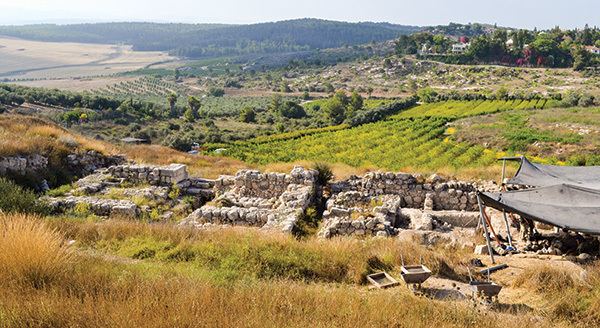
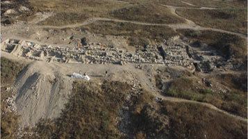
Tel gezer israel
Gezer, or Tel Gezer (Hebrew: גֶּזֶר)(also Tell el-Jezer) is an archaeological site in the foothills of the Judaean Mountains at the border of the Shfela region roughly midway between Jerusalem and Tel Aviv. It is now an Israeli national park. In the Hebrew Bible, Gezer is associated with Joshua and Solomon.
Contents
- Tel gezer israel
- Excavating tel gezer in israel
- Location
- Early Bronze Age
- Middle Bronze Age
- Late Bronze Age
- Iron Age
- Tiglath Pileser III and the Neo Assyrian period
- Hellenistic period
- Post Hellenistic periods
- Crusader period
- Bible the sack of Gezer
- Identifying the pharaoh
- History of excavation
- Gezer calendar
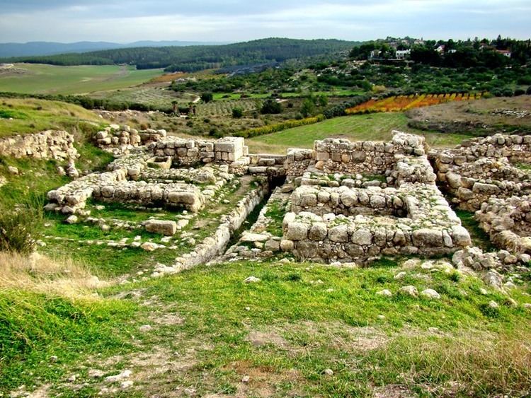
- Canaanite city gate wall
- Israelite city gate wall
- Canaanite water tunnel
- Boundary stones
- Temple of Amun
- References
It became a major fortified Canaanite city-state in the first half of the 2nd millennium BCE. It was later destroyed by fire and rebuilt. The Amarna letters mention kings of Gezer swearing loyalty to the Egyptian Pharaoh. Its importance was due in part to the strategic position it held at the crossroads of the ancient coastal trade route linking Egypt with Syria, Anatolia and Mesopotamia, and the road to Jerusalem and Jericho, both important trade routes.
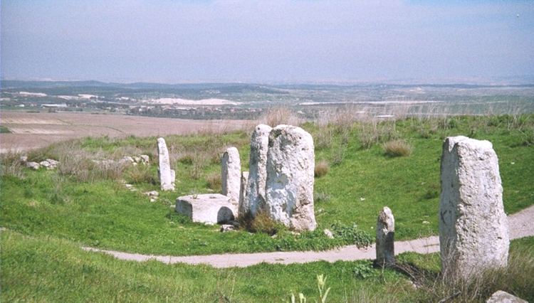
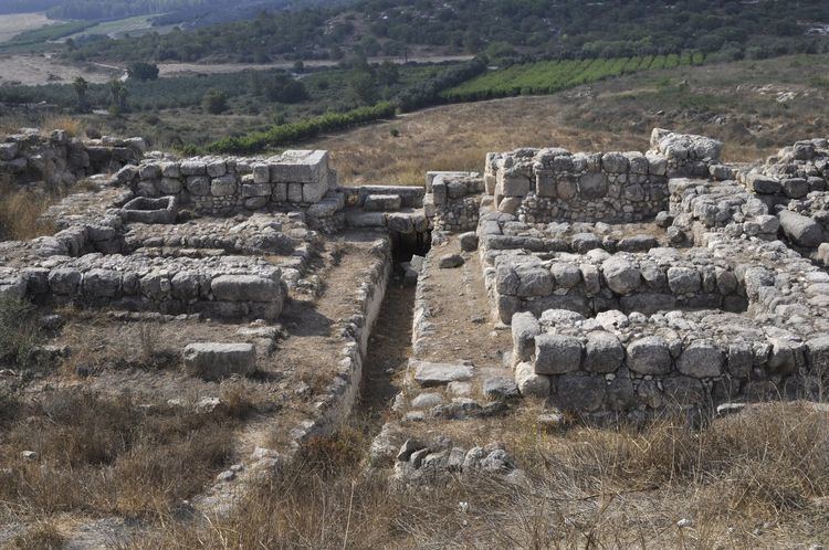
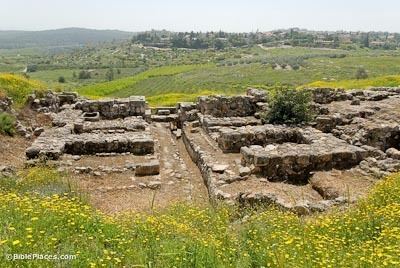
Discoveries related to biblical archaeology include: a probable Canaanite high place with ten monumental megaliths (up-ended stones, each of which is called a masseba or matseva, plural massebot/matsevot; such are found elsewhere in Israel, but the Gezer massebot are the most impressive examples); a double cave beneath the high place, but predating and not connected to it; 13 inscribed boundary stones, making it the first positively identified biblical city; a six-chambered gate similar to those found at Hazor and Megiddo; and a large Canaanite water system comprising a tunnel going down to a spring, similar to those found in Jerusalem, Hazor and Megiddo.
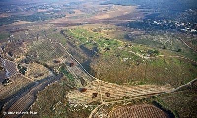
Excavating tel gezer in israel
Location
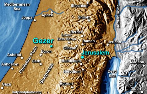
Gezer was located on the northern fringe of the Shephelah region, approximately thirty kilometres northwest of Jerusalem. It was strategically situated at the junction of the Via Maris, the international coastal highway, and the highway connecting it with Jerusalem through the valley of Ayalon, or Ajalon.

Verification of the identification of this site with biblical Gezer comes from bilingual inscriptions in either Hebrew or Aramaic, and Greek, found engraved on rocks several hundred meters from the tell. These inscriptions from the 1st century BCE read "boundary of Gezer" and "of Alkios" (probably the governor of Gezer at the time).
Early Bronze Age
Inhabitants of the first settlement at Gezer, toward the end of the 4th millennium BCE, lived in large rock-cut caves.
In the Early Bronze Age, an unfortified settlement covered the tell. It was destroyed in the middle of the 3rd millennium BCE and abandoned for several hundred years.
Middle Bronze Age
In the Middle Bronze Age (first half of the 2nd millennium BCE), Gezer became a major city, well fortified and containing a large cultic site.
The Canaanite city was destroyed in a fire, presumably in the wake of a campaign by the Egyptian pharaoh Thutmose III (ruled 1479–1425 BC). The oldest known historical reference to the city is to be found on an inscription of conquered sites at Thutmose's temple at Karnak.
The Tell Amarna letters, dating from the 14th century BCE, include ten letters from the kings of Gezer swearing loyalty to the Egyptian pharaoh. The city-state of Gezer (named Gazru in Babylonian) was ruled by four leaders during the 20-year period covered by the Amarna letters. Discoveries of several pottery vessels, a cache of cylinder seals and a large scarab with the cartouche of Egyptian pharaoh Amenhotep III attest to the existence of a city at Gezer's location in the 14th century BCE - one that was apparently destroyed in that century - and suggest that the city was inhabited by Canaanites with strong ties to Egypt.
FortificationsThe tell was surrounded by a massive stone wall and towers, protected by a five meter high earthen rampart covered with plaster. The wooden city gate, near the southwestern corner of the wall, was fortified by two towers.
Cultic site with massebotCultic remains discovered at the site were a row of ten large standing stones, known as massebot, oriented north-south, the tallest of which was 3 meters high, with an altar-type structure in the middle, and a large, square, stone basin. The exact purpose of these megaliths is still debated, but they may have constituted a Canaanite "high place" from the Middle Bronze Age, ca. 1600 B.C.E.
Late Bronze Age
In the Late Bronze Age (second half of the 2nd millennium BCE) a new fortification wall, four meters thick, was erected. In the 14th century BCE, a palace was constructed on the high western part of the tell. Toward the end of the Bronze Age, the city declined and its population diminished. Gezer is mentioned in the victory stele of Merneptah, dating from the end of the 13th century BCE.
Iron Age
In 12th-11th centuries BCE, a large building with many rooms and courtyards was situated on the acropolis. Grinding stones and grains of wheat found among the sherds indicate that it was a granary. Local and Philistine vessels attest to a mixed Canaanite/Philistine population.
Tiglath-Pileser III and the Neo-Assyrian period
The Neo-Assyrian king Tiglath-Pileser III put Gezer under siege between the years 734 and 732 BC. The city was probably captured by the Assyrians at the end of the campaign of Tiglath-Pileser III to Canaan. A reference to Gezer may have appeared in a cuneiform relief from the 8th-century BCE royal palace of Tiglath-Pileser III at Nimrud. The siege may have been the one depicted on a stone relief at the royal palace in Nimrud, where the city was called 'Gazru'. Nimrud itself was destroyed in 2016 by the "islamic state" cult and those artifacts were lost or destroyed.{http://www.bbc.com/news/world-middle-east-37997644}
Recent archaeological excavation at the site reveals that not long after the city fell into Assyrian hands it became an Assyrian administrative center.
Hellenistic period
During the Hellenistic period, Gezer was fortified by Maccabees and was ruled by the independent Jewish Hasmonean dynasty.
Post-Hellenistic periods
Gezer was sparsely populated during Roman times and later times, as other regional population centers took its place.
Crusader period
In 1177, the plains around Gezer were the site of the Battle of Montgisard, in which the Crusaders under Baldwin IV defeated the forces of Saladin.
Bible: the sack of Gezer
According to the Hebrew Bible, the only source for the event, the Sack of Gezer took place at the beginning of the 10th century BCE, when the city was conquered and burned by an unnamed Egyptian pharaoh, identified by some with Siamun, during his military campaign in Palestine. This anonymous Egyptian pharaoh then gave it to King Solomon as the dowry of his daughter. Solomon then rebuilt Gezer and fortified it.
The Bible states:
.... King Solomon .... build .... the wall of .... Gezer (Pharaoh king of Egypt had gone up and captured Gezer and burned it with fire, and had killed the Canaanites who lived in the city, and had given it as dowry to his daughter, Solomon's wife;
Identifying the pharaoh
The only mention in the Bible of a pharaoh who might be Siamun (ruled 986–967 BC) is the text from 1 Kings quoted above, and we have no other historical sources that clearly identify what really happened. As shown below, Kenneth Kitchen believes that Siamun conquered Gezer and gave it to Solomon. Others such as Paul S. Ash and Mark W. Chavalas disagree, and Chavalas states that "it is impossible to conclude which Egyptian monarch ruled concurrently with David and Solomon". Professor Edward Lipinski argues that Gezer, then unfortified, was destroyed late in the 10th century (and thus not contemporary with Solomon) and that the most likely Pharaoh was Shoshenq I (ruled 943–922 BC). "The attempt at relating the destruction of Gezer to the hypothetical relationship between Siamun and Solomon cannot be justified factually, since Siamun's death precedes Solomon's accession."
History of excavation
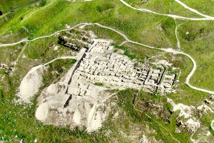
Archaeological excavation at Gezer has been going on since the early 1900s, and it has become one of the most excavated sites in Israel. The site was identified with ancient Gezer by Charles Simon Clermont-Ganneau in 1871. R. A. Stewart Macalister excavated the site between 1902 and 1909 on behalf of the Palestine Exploration Fund. Macalister recovered several artifacts discovered several constructions and defenses. He also established Gezer's habitation strata, though due to poor stratigraphical methods, these were later found to be mostly incorrect (as well as many of his theories). Other notable archaeological expeditions to the site were made by Alan Rowe (1934), G.E. Wright, William Dever and Joe Seger between 1964 and 1974 on behalf of the Nelson Glueck School of Archaeology in the Hebrew Union College, again by Dever in 1984 and 1990, as well as the Andrews University.
Excavations were renewed in June 2006 by a consortium of institutions under the direction of Steve Ortiz of the Southwestern Baptist Theological Seminary (SWBTS) and Sam Wolff (Israel Antiquities Authority). The Tel Gezer Excavation and Publication Project is a multi-disciplinary field project investigating the Iron Age history of Gezer.
The first season of the Gezer excavations concluded successfully and revealed some interesting details. Among other things, is a discovery of thick destruction layer that may be dated to the destruction of Siamun (1 Kings 9:16).‹See TfD›
IN 2011 BorderStone Press launched a "Research Israel" project in cooperation with the New Orleans Baptist Theological Seminary (NOBTS) to participate in the dig and to document and publish a book on the findings.
"Gezer calendar"
One of the best-known finds is the Gezer calendar. This is a plaque containing a text appearing to be either a schoolboy's memory exercises, or something designated for the collection of taxes from farmers. Another possibility is that the text was a popular folk song, or child's song, listing the months of the year according to the agricultural seasons. It has proved to be of value by informing modern researchers of ancient Middle Eastern script and language, as well as the agricultural seasons.
Canaanite city gate, wall
In 2013 the NOBTS team launched a side effort to preserve the ancient Canaanite mudbrick gate and complex near the water system.
Israelite city gate, wall
In 1957 Yigael Yadin identified a wall and gateway very similar in construction to remains excavated at Megiddo and Hazor as Solomonic; they have since been identified as dating from the early Israelite kingdom, some centuries later.
Canaanite water tunnel
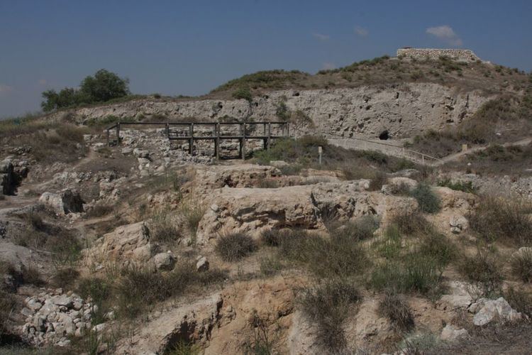
In 2010 a team from NOBTS launched an effort to clear a massive water tunnel, discovered first by Macalister over a hundred years earlier. Macalister never fully excavated the tunnel because a strong storm blew debris back into the tunnel and he considered it too expensive and time-consuming to re-excavate the site. The NOBTS effort to re-clear and examine the tunnel has been chronicled in multiple sources including the Biblical Archaeology Review and the Baptist Press. In 2011 Professor Dennis Cole, archaeologist Dan Warner and engineer Jim Parker from NOBTS, led another team in an attempt to finish the effort. In just two years the teams removed approximately 299 tons of debris from the ancient water system.
In 2010, the team removed approximately 1,040 cubic feet (39 cubic yards – 29 cubic meters) of debris (approximately 50 percent rock and 50 percent dirt), equating to approximately 68 tons. In 2011 the team removed approximately 3,560 cubic feet (132 cubic yards- 101 cubic meters), equating to approximately 231 tons.
In 2012 the Gezer team uncovered a large open cavern at the bottom of the water system. Said Dr. Warner "Opening the cave is something we have been working toward for three summers wondering if it even existed...It gave me a rush. Once inside it gave us a sense of accomplishment and satisfaction, but we are not done by a long shot."
In 2013 the NOBTS team launched a side effort to preserve the ancient Canaanite mudbrick gate and complex near the water system. In the water system "[m]ost of the first two weeks of the dig were spent searching for the bottom step and cleaning Macalister's causeway. Tons of debris and rocks were removed in the process. When the bottom step was located and the causeway area clear, the team excavated three probes in the pool area. Each of the pool probes reached a depth of more than six feet before the end of the season and the bottom of the pool was discovered in only one probe (Eastern probe) — the one just below the bottom step of the water shaft."
Boundary stones
13 boundary stones have been identified at the site, probably dating from the Late Hellenistic period (1st century BCE), the most recent having been found by archaeologists from SWBTS. See also Gezer#Location.
Temple of Amun
One fragmentary but well-known surviving triumphal relief scene from the Temple of Amun at Tanis believed to be related to the sack of Gezer depicts an Egyptian pharaoh smiting his enemies with a mace. There can be no doubt that the person shown on this relief was Siamun as the eminent British Egyptologist, Kenneth Kitchen, stresses in his book, On the Reliability of the Old Testament. Siamun appears here "in typical pose brandishing a mace to strike down prisoners(?) now lost at the right except for two arms and hands, one of which grasps a remarkable double-bladed axe by its socket." The writer observes that this double-bladed axe or 'halberd' has a flared crescent-shaped blade which is close in form to the Aegean influenced double axe but is quite distinct from the Canaanite double-headed axe which has a different shape that resembles an X. Thus, Kitchen concludes Siamun's foes were the Philistines who were descendants of the Aegean-based Sea Peoples and that Siamun was commemorating his recent victory over them at Gezer by depicting himself in a formal battle scene relief at the Temple in Tanis. More recently Paul S. Ash has put forward a detailed argument that Siamun's relief portrays a fictitious battle. He points out that in Egyptian reliefs Philistines are never shown holding an axe, and that there is no archaeological evidence for Philistines using axes. He also argues that there is nothing in the relief to connect it with Philistia or the Levant.