
Existed: 1920 – present Constructed 1920 | Length 347.6 km | |
 | ||
Counties | ||
Georgia state route 74 i 85 to ga 85 hd
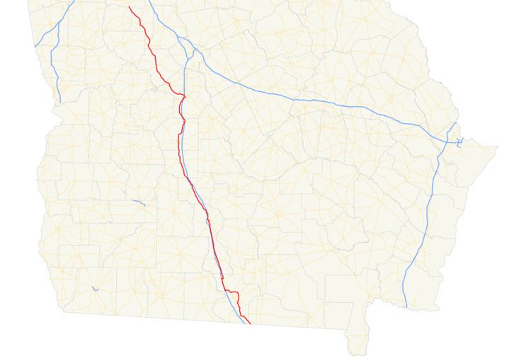
State Route 7 (SR 7) is a 216.0-mile-long (347.6 km) state highway that travels in a southeast-to-northwest orientation through portions of Lowndes, Cook, Tift, Turner, Crisp, Dooly, Houston, Peach, Crawford, Monroe, Lamar, Pike, and Spalding counties in the southern and central parts of the U.S. state of Georgia. The highway connects the Florida state line southeast of Lake Park to the Griffin area, via Valdosta, Tifton, Cordele, Perry, and Barnesville. The highway is concurrent with either US 41 or US 341 for its entire length, and closely parallels I-75 for much of its length.
Contents
- Georgia state route 74 i 85 to ga 85 hd
- Map of State Rte 7 Tifton GA 31794 USA
- Echols and Lowndes counties
- Cook Tift and Turner counties
- Crisp Dooly and Houston counties
- Peach Crawford and Monroe counties
- Lamar Pike and Spalding counties
- National Highway System
- 1920s and 1930s
- 1940s1960s
- 1970s 2000s
- Valdosta business loop
- Valdosta alternate route
- Lowndes County connector route
- Perry spur route
- Fort Valley connector route
- References
Map of State Rte 7, Tifton, GA 31794, USA
SR 7 was built in 1920 along nearly the same path it travels today. US 41/SR 7 was designated on a concurrency with I-75 northwest of Valdosta to Hahira in 1982. US 41/SR 7 were re-routed onto an eastern bypass of Valdosta in 2006.
Echols and Lowndes counties
SR 7 begins at the Florida state line, southeast of Lake Park. Here, the roadway continues as US 41/State Road 25 (Plum Street). US 41/SR 7 travels to the northwest, within Echols County, paralleling a Norfolk Southern Railway. Less than 1 mile (1.6 km) later, they enter Lowndes County. The two highways enter Lake Park, where they have a concurrency with SR 376. During the concurrency, the three highways travel north of Clayton Lake and the Francis Lake Golf Course. After the concurrency ends, US 41/SR 7 travels northeast of Horselot Lake and to the east of the Twin Lakes. After traveling through Dasher, they have an intersection with the southern terminus of US 41 Bus./SR 7 Bus. (South Patterson Street). This intersection also marks the southern end of a concurrency with SR 31. US 41/SR 7/SR 31 travels to the north-northeast on Inner Perimeter Road on what is essentially a bypass of the main part of Valdosta. They intersect SR 94 (New Statenville Highway). They curve to a northerly direction and enter the eastern part of the city. After curving to the north-northwest, they intersect US 84/US 221/SR 38 (East Hill Avenue). Here, US 221 joins the concurrency. The four highways travel to the north-northwest and curve to the northwest just before reaching East Park Avenue. Here, US 221/SR 31 departs the concurrency. US 41/SR 7 curves to the west and intersects SR 125 (Bemiss Road). Just northwest of Five Points Shopping Center, they intersect the northern terminus of US 41 Bus./SR 7 Bus. (North Ashley Street). The two highways travel between Valdosta Country Club and Langdale Park. On the northern edge of the park, they cross over the Withlacoochee River. They curve to the west-southwest to an interchange with Interstate 75 (I-75), with which they begin a concurrency to the north-northwest. I-75/US 41/SR 7 passes by Stone Creek Golf Club. The three highways enter Hahira, where they have an interchange with SR 122. At this interchange, US 41/SR 7 departs from I-75 and travel concurrent with SR 122 into the main part of town and depart by turning north-northwest onto Church Street. Then, the concurrency enters Cook County.
Cook, Tift, and Turner counties
US 41/SR 7 travels through the town of Cecil and then enters Adel. There, they intersect SR 37/SR 76 (4th Street). Immediately after leaving the city, they travel through Sparks. After Lenox, the two highways enter Tift County. On the southwestern edge of Henry Tift Myers Airport, they begin a concurrency with SR 125. The three highways travel along the southeastern edge of Unionville, before entering Unionville proper for less than 1,500 feet (460 m). When they leave Unionville, they immediately enter Tifton. In the main part of town, they intersect US 82/US 319/SR 35/SR 520 (5th Street). Just to the west-northwest of Fulwood Park, SR 125 splits off to the east-southeast, while US 41/SR 7 continues to the west-northwest and curve to the north-northwest to an interchange with I-75. After traveling through Chula, and passing southwest of the Golf Club of South Georgia, they enter Turner County. In Sycamore, they intersect SR 32 (Jefferson Davis Highway), which joins the concurrency. The three highways pass Turner County Airport to its west and enter Ashburn. In the main part of town, they intersect SR 112. At this intersection, SR 32 departs the concurrency to the southwest. About three blocks later, US 41/SR 7 intersects the southern terminus of SR 159 (North Street). After traveling through rural areas of the county, they enter Crisp County.
Crisp, Dooly, and Houston counties
After traveling through Arabi, US 41/SR 7 continues toward Cordele. They intersect SR 33 Conn. (Rockhouse Road East). After intersecting the northern terminus of SR 33, they intersect SR 300 (Georgia–Florida Parkway). The two highways then enter Cordele, where they intersect US 280/SR 30/SR 90 (16th Avenue). At this intersection, SR 90 joins the concurrency. After traveling on the west side of both Crisp Regional Hospital and the Crisp County-Cordele Airport, the three highways leave the city to the north and enter Dooly County. They enter Vienna, where they intersect SR 27 (Union Street). At this intersection, SR 90 departs the concurrency to the west-northwest, while US 41/SR 7 continues to the north. Just before leaving the city, they pass Vienna City Cemetery. They travel through Pinehurst and enter Unadilla. There, they have another interchange with I-75 in the southwestern part of the city. In downtown, they have a one-block concurrency with SR 230. Then, they enter Houston County. Approximately 0.5 miles (0.80 km) northwest of the county line, the two highways cross under, but don't have an interchange with, I-75. In Henderson, they intersect SR 26. After traveling on the west side of the Flat Creek Public Fishing Area, they enter Perry. In the city, they intersect Perry Parkway. Then, they curve along the western side of I-75 for approximately 1,000 feet (300 m), where they curve slightly to the northwest and intersect SR 127/SR 224 (Marshallville Road). The four highways travel to the east and immediately have an interchange with I-75. They curve to the southeast on Golden Isles Parkway, before US 41/SR 7/SR 127 departs to the northeast on General Courtney Hodges Boulevard. This is at an intersection with the northern terminus of SR 7 Spur, which is a former section of US 41/SR 7. The three highways travel to the southeast of Creekwood Park and just north of Evergreen Cemetery. After rounding a slight curve, they intersect US 341/SR 11 Bus. At this intersection, US 341/SR 7 travels to the north-northwest, while US 41/SR 11 Bus./SR 127 continues to the east-northeast. US 341/SR 7 gradually takes more of a northwesterly routing and have an interchange with I-75. They curve to the west-northwest and intersect US 341 Byp./SR 11 Conn. (Perry Parkway) and leave the city. Approximately 1 mile (1.6 km) later, they enter Peach County.
Peach, Crawford, and Monroe counties
US 341/SR 7 travels to the northwest through rural parts of the county and enter Fort Valley. In the main part of the city, they turn to the northeast and intersect the western terminus of SR 7 Conn. (East Church Street). They curve to a due-north routing and intersect SR 96, which joins the concurrency. Approximately 500 feet (150 m) later, they begin a curve to the west and intersect SR 49 (North Camellia Boulevard). Immediately afterward, US 341/SR 7 turns back to the north, while SR 96 travels to the west. The concurrent routes curve to the north-northwest, then to the west, and to the northwest before intersecting SR 49 Conn. (Fall Line Freeway). Approximately 1 mile (1.6 km) later, they enter Crawford County. After traveling through rural portions of the county, the concurrency curves to a nearly due-north routing and enters Roberta. In town, they intersect the northern terminus of SR 128 (West Agency Street). Two blocks later, they intersect US 80/SR 22/SR 42 (Crusselle Street). At this intersection, SR 42 joins the concurrency. The three highways curve to the northwest into Musella, where SR 42 departs the concurrency. US 341/SR 7 continues on a nearly northwestern routing and enters Monroe County. They cut through the northeastern corner of Culloden. Just north-northeast of town, they curve to the north-northeast and intersect SR 74. Southwest of Strouds, they intersect the southern terminus of SR 83. The two highways curve back to the northwest and enter Lamar County.
Lamar, Pike, and Spalding counties
US 341/SR 7 travels along the western edge of Deer Trail Country Club and continue to the north-northwest. Just southeast of Barnesville, they intersect with US 41/SR 18 (Martin Luther King Jr. Parkway). At this intersection, US 341 reaches its northern terminus, and US 41/SR 7/SR 18 travels concurrent to the northwest. Almost immediately, they enter the city limits of Barnesville. At Thomaston Street, SR 36 joins the concurrency. The four highways cross over a Norfolk Southern Railway line and curve to the north-northeast. SR 18 departs the concurrency on Burnette Road. The concurrency crosses over another Norfolk Southern Railway line and curve to the north-northwest. They have an incomplete interchange with Aldora, Zebulon, and Elm Streets. The exit is only available for the southbound lanes and is only marked as leading to Aldora. Just northwest of Barnesville, SR 36 departs the concurrency. US 41/SR 7 curves to the northwest and crosses over a Norfolk Southern Railway before crossing the northeastern corner of Pike County. Approximately 3,000 feet (910 m) after entering Spalding County, they intersect US 19/SR 3 south of Griffin. This intersection is the northern terminus of SR 7; it also marks the southern terminus of US 19 Bus./US 41 Bus./SR 155 (Zebulon Road).
National Highway System
The only section of SR 7 that is part of the National Highway System, a system of roadways important to the nation's economy, defense, and mobility, is from the south end of its concurrency with SR 31 southeast of Valdosta to the north end of its concurrency with I-75 in Hahira
1920s and 1930s
SR 7 was built in 1920 on roughly the same route as it travels now. By the end of 1926, US 41 had been designated along the Florida state line–Perry, as well as the Barnesville–Griffin segment, as it does today. The path of SR 7 was paved on a brief section north-northwest of Valdosta, one north-northwest of Adel, one south-southeast of Tifton, one north-northwest of Tifton, and the entire Barnesville–Griffin segment. Also, the Florida–Valdosta segment, nearly the entire Valdosta–Adel segment, a segment from south of Cordele to Pinehurst, and the middle part of the Roberta–Barnesville segment, were being prepped for paving. By 1932, the entire route, from the Florida state line to the Peach–Crawford county line, just northwest of Fort Valley, and the middle part of the Roberta–Barnesville segment, were paved. In February of that year, the segment between the two paved sections was itself being prepared for paving. By May 1933, the final section, south-southeast of Barnesville, was being prepared for paving. In mid-1937, the then-entire route of SR 7 was paved. By October of that year, US 41 had been designated along the entire length of SR 7. It was moved onto the Perry–Barnesville segment. By August 1938, US 41's move onto SR 7 had been reverted.
1940s–1960s
By the end of 1946, SR 7 Spur, what would eventually be signed as SR 7 Alternate was designated in Valdosta. By April 1949, US 341 had been designated along the segment of SR 7 between Perry and Barnesville. Between 1960 and 1963, SR 7 Spur had been redesignated as SR 7 Loop. Also, SR 7 Connector, which is now part of the US 41/SR 7 mainline, was designated northwest of Valdosta. Between 1963 and 1966, US 41/SR 7 were re-routed in Perry. Most of the former route was redesignated as SR 7 Spur.
1970s-2000s
In 1970, SR 7 Connector was designated in Fort Valley. In 1982, SR 7 Loop was redesignated as SR 7 Alternate. Also, US 41/SR 7 were designated over the former SR 7 Connector northwest of Valdosta and were routed on a concurrency with I-75 from SR 7 Connector's former northern terminus to Hahira, as they do today. In 1997, Inner Perimeter Road, which would eventually take US 41/SR 7 on an easterly bypass of Valdosta was built. In 2006, US 41/SR 7 were re-routed onto Inner Perimeter Road. The old route through Valdosta was redesignated as US 41 Business/SR 7 Business.
Valdosta business loop
State Route 7 Business (SR 7 Bus.) is a 7.0-mile-long (11.3 km) business route of SR 7 that exists entirely within the west-central part of Lowndes County. Nearly the entire route travels within the city limits of Valdosta. It travels concurrent with US 41 Bus. for its entire length.
US 41 Bus./SR 7 Bus. begins just southeast of Valdosta's city limits, at an intersection with US 41/SR 7/SR 31 (Inner Perimeter Road). The business routes travel to the northwest on South Patterson Street and pass just to the southwest of Payton Park. A short distance later, they intersect the western terminus of SR 94 (Griffin Avenue). Just north of Olympic Park, the southbound and northbound lanes split onto one-way pairs. The southbound lanes continue on Patterson Street, and the northbound lanes travel on Ashley Street. They intersect US 84/US 221/SR 38 on one-way pairs. The southbound lanes intersect the southern terminus of SR 7 Alt. (North Patterson Street). At West Magnolia Street, the two directions travel together again. US 41 Bus./SR 7 Bus. travel nearly due north, just to the east of Valdosta State University, between Drexel Park and Vallotton Park. Just past East Park Avenue, they curve to the north-northwest and intersect the southern terminus of SR 125 (Bemiss Road). Slightly more than 400 feet (120 m) later, the two highways pass by South Georgia Medical Center and then Billy Grant Baseball Field. Next to the Five Points Shopping Center, they intersect the northern terminus of SR 7 Alt. (North Patterson Street). Then, they curve to the west-northwest and meet their northern terminus, another intersection with the US 41/SR 7 mainline.
All of SR 7 Bus. is included as part of the National Highway System, a system of roadways important to the nation's economy, defense, and mobility.
The entire route is in Lowndes County.
Valdosta alternate route
State Route 7 Alternate (SR 7 Alt.) is a 2.8-mile-long (4.5 km) alternate route that exists entirely within the west-central part of Lowndes County and travels completely within the city limits of Valdosta.
SR 7 Alt. begins at an intersection with the southbound lanes of I-75 Bus./US 41 Bus./SR 7 Bus. in downtown Valdosta. It travels to the north-northwest and enters Valdosta State University. Within the university, the highway curves to a more-due north orientation and passes just to the west of Drexel Park. At East Park Avenue, the highway begins to travel due north. It then passes west of the South Georgia Medical Center. It curves to the north-northwest and travels to the east of McKey Park and Valdosta Middle School. Next to the Five Points Shopping Center, it meets its northern terminus, a second intersection with the southbound lanes of US 41 Bus./SR 7 Bus. There is an "end" sign at the corner of North Patterson Street and Smithbriar Drive (due to the roadway north of there being southbound only). Traffic on SR 7 Alt. heading to US 41 Bus./SR 7 Bus. is required to turn right onto Smithbriar Drive for one block.
The roadway that would eventually become SR 7 Alt, was built in 1946 as SR 7 Spur. At this time, it extended from what is now US 41 Bus./SR 7 Bus. south of its current southern terminus along its current alignment. Between 1960 and 1963, SR 7 Spur had been redesignated as SR 7 Loop. In 1982, SR 7 Loop was redesignated as SR 7 Alt.
The entire route is in Valdosta, Lowndes County.
Lowndes County connector route
State Route 7 Connector (SR 7 Conn.) was a 1.3-mile-long (2.1 km) connector route that existed entirely within the west-central part of Lowndes County and traveled northwest of Valdosta. This highway was eventually redesignated as part of the re-routing of US 41/SR 7 in 1982. That was when they were re-aligned to travel concurrent with I-75.
The entire route is in Lowndes County.
Perry spur route
State Route 7 Spur (SR 7 Spur) is a 0.3-mile-long (0.48 km) spur route that exists entirely within the west-central part of Houston County and travels completely within the city limits of Perry. It is known locally as General Courtney Hodges Boulevard, after Courtney Hodges, the United States Army general that was born in Perry. It was formerly part of the routing of US 41/SR 7 before they were re aligned through the city.
SR 7 Spur begins at a point of General Courtney Hodges Boulevard near where US 41/SR 7 formerly crossed over Interstate 75 (I-75) in the southern part of Perry. It travels to the northeast, passing the Perry Area Chamber of Commerce and the Perry Welcome Center, and meets its northern terminus, an intersection with US 41/SR 7/SR 127/SR 224 in the main part of the city.
Between 1963 and 1966, US 41/SR 7 were re-routed though the southern part of Perry. Most of the former part was redesignated as SR 7 Spur.
The entire route is in Perry, Houston County.
Fort Valley connector route
State Route 7 Connector (SR 7 Conn.) is a 0.2-mile-long (0.32 km) connector route that exists entirely within the west-central part of Peach County and travels completely within the city limits of Fort Valley. It is known locally as East Church Street.
SR 7 Conn. begins at an intersection with US 341/SR 7 (Oakland Heights Parkway) in the central part of Fort Valley. It travels due east to meet its eastern terminus, an intersection with SR 96 in the eastern part of the city.
In 1970, SR 7 Conn. was designated along its current length.
The entire route is in Fort Valley, Peach County.