
Length 135 km | ||
 | ||
Counties | ||
State Route 47 (SR 47) is an 83.9-mile-long (135.0 km) arc-shaped state highway that runs through portions of Taliaferro, Wilkes, Lincoln, Columbia, McDuffie, and Jefferson counties in the east-central part of the U.S. state of Georgia. The route connects Crawfordville and Wrens, via Washington and Harlem.
Contents
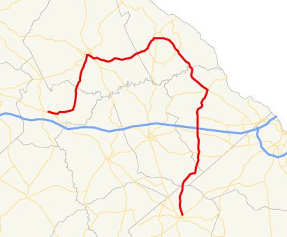
Map of GA-47, Georgia, USA
Route description
SR 47 begins at an intersection with US 278/SR 12 (Broad Street) in Crawfordville, within Taliaferro County. SR 47 runs parallel with US 278/SR 12 for about 1 mile (1.6 km). It head east-northeast to the town of Sharon, where it meets the northern terminus of SR 269 (Barnett Road SE). At this intersection, SR 47 turns to head to the north-northeast. It travels through rural areas of the county and crosses into Wilkes County. A few miles farther is a bridge over the Little River. The highway continues to the north-northeast and enters Washington. It intersects US 78 Business/SR 10 Business (Robert Toombs Avenue). The three routes head concurrently to the east. At an intersection with Poplar Drive, SR 17 Business joins the concurrency and all four head southeast. They intersect US 78/SR 10/SR 17 (Thomson Road), as well as US 378. At this intersection, all of the business routes end, US 378 begins, and SR 47 heads concurrent along US 378. Less than 1,000 feet (300 m) later, US 378/SR 47 meet the northern terminus of SR 47 Connector (Thomson Road). Then, they travel through rural areas of the county before crossing into Lincoln County. In Lincolnton, they intersect SR 43. At this intersection, US 378/SR 43 head north-northeast on Washington Street, while SR 43/SR 47 head east on Elm Avenue. Just over 1,000 feet (300 m) later, SR 43 splits off to the southeast, while SR 47 continues to the east. It curves to the southeast and intersects SR 220 before crossing over Little on the Price–Legg Bridge and entering Columbia County. At the county line, it takes on the Washington Road name. After a southerly jog, they continue to the southeast, skirting along the western edge of Pointes West Army Resort. Then, they cross over Kegg Creek on the Major Byron S. McGuire Sr. Memorial Bridge, just before skirting along the southwestern edge of Wildwood Park. Just over 1 mile (1.6 km) later, the roadway enters Pollards Corner. There, they intersect with SR 150 (Cobbham Road). SR 47/SR 150/Washington Road travel concurrently for one block. At an intersection with U.S. Route 221 (US 221), SR 47 splits off to travel concurrent with US 221 south, while SR 150 splits off to travel concurrent with US 221 north. Just before entering Appling, the two roads curve to the south. They pass through Appling and meet the western terminus of SR 232 (Columbia Road). Farther to the south is an interchange with Interstate 20 (I-20, Carl Sanders Highway) and an intersection with SR 223 (Wrightsboro Road). The highway continues to the south and intersects US 78/US 278/SR 10 (Milledgeville Road) in Harlem. They curve to the south-southwest before entering McDuffie County. The concurrency begins to parallel the western edges of Fort Gordon and curve to the southwest. They pass through rural areas of the county, and curve back to the south-southwest, before entering Jefferson County. After leaving the Fort Gordon area they continue in a mostly southern routing and enter Wrens. On the northeastern edge of town, they intersect US 1/SR 4 (North Main Street). At this intersection, SR 47 ends and US 221 turns to the right to follow US 1/SR 4 into the main part of town.
SR 47 is not part of the National Highway System, a system of roadways important to the nation's economy, defense, and mobility.
Bannered route
State Route 47 Connector (SR 47 Connector) is a 0.1-mile-long (0.16 km) connector route located completely within the central part of Wilkes County in the east-central part of the U.S. state of Georgia. Its entire length is just southeast of Washington. It is known as Thomson Road for its entire length.
It begins at an intersection with US 78/SR 10/SR 17 (Thomson Road), where the roadway continues as Denard Road. The highway travels to the northeast to meet its northern terminus, an intersection with US 378/SR 47 (Lincolnton Road).
SR 47 Connector is not part of the National Highway System, a system of roadways important to the nation's economy, defense, and mobility.
The entire route is in Wilkes County.