
Length 26.4 km | ||
 | ||
Counties | ||
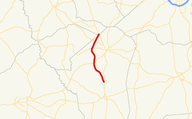
State Route 296 (SR 296) is a south-north state highway located in the east-central part of the U.S. state of Georgia. The route travels from US 1/US 221/SR 4/SR 17 north of Louisville to SR 17 northwest of Wrens.
Contents
Map of GA-296, Stapleton, GA 30823, USA
Route description
SR 296 begins at an intersection with US 1/US 221/SR 4/SR 17 approximately 3.6 miles (5.8 km) north of Louisville, in Jefferson County. It heads northwest to an intersection with SR 88 approximately 3.9 miles (6.3 km) southwest of Wrens. Just before that intersection, the highway assumes more of a northerly routing to the town of Stapleton, where it intersects SR 102. After leaving Stapleton, SR 296 assumes a more northeasterly routing. After intersecting SR 80 approximately 3.9 miles (6.3 km) northwest of Wrens, the route leaves Jefferson County, briefly cutting across the extreme eastern corner of Glascock County. Shortly after entering Warren County, the route meets its northern terminus, an intersection with SR 17 approximately 4.9 miles (7.9 km) northwest of Wrens.
SR 296 mainly serves to connect US 1/US 221/SR 4 and SR 17 with the town of Stapleton. Largely a rural route, SR 296 sees an Average Annual Daily Traffic (AADT) of less than 2,000 vehicles.