
Length 436.3 km | ||
 | ||
Counties Chattahoochee County, Georgia | ||
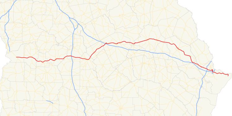
State Route 26 (SR 26) is a 271.1-mile-long (436.3 km) state highway that travels west-to-east through portions of Chattahoochee, Marion, Schley, Macon, Houston, Pulaski, Bleckley, Laurens, Johnson, Emanuel, Bulloch, Bryan, and Chatham counties through the central part of the U.S. state of Georgia. It crosses nearly the entire width of the state, connecting Cusseta, on the southeastern edge of Fort Benning, near Columbus to Tybee Island on the Atlantic coast near Savannah, via Buena Vista, Ellaville, Oglethorpe, Hawkinsville, Cochran, Dublin, Swainsboro, Statesboro, and Savannah.
Contents
- Map of GA 26 Georgia USA
- Chattahoochee to Houston countess
- Houston to Laurens counties
- Laurens to Bryan counties
- Bryan to Chatham counties
- National Highway System
- Garden City connector route
- Savannah loop route
- References
Map of GA-26, Georgia, USA
Chattahoochee to Houston countess
SR 26 begins at an intersection with US 27/US 280/SR 1/SR 520 (South Georgia Parkway) in Cusseta, in the southeastern part of Fort Benning, in Chattahoochee County. Just over 1,000 feet (300 m) later, it exits the base's border and crosses over a Norfolk Southern Railway line. It proceeds to the east on Clarke Duncan Highway and travels to the north of Chattahoochee County High School. At Box Springs Road, SR 137 joins SR 26 in a brief concurrency. Approximately 0.3 miles (0.48 km) later, SR 137 departs to the northeast. A short distance later, SR 26 crosses over a Norfolk Southern Railway line and re-enters Fort Benning for just over 1 mile (1.6 km). At that point, the highway exits Fort Benning, Cusseta, and Chattahoochee County, and enters Marion County. South of Glen Alta, SR 26 intersects the southern terminus of SR 355 (Hatcher Road). Farther to the east, in Buena Vista, is an intersection with the southern terminus of SR 41 Conn. (Baker Street). One block later, SR 26 intersects the SR 41 mainline (Broad Street). Just past the Short Street intersection, the roadway begins paralleling a Norfolk Southern Railway line to the southeast. The highway then enters Schley County. Around the northwestern city limits of Ellaville, SR 26 and the Norfolk Southern Railway line take different paths to get to downtown. In downtown is an intersection with the northern terminus of SR 153. The highway curves to the east-northeast direction. Just before leaving the city limits of Ellaville, SR 26 intersects US 19/SR 3. After leaving town, it continues traveling to the east-northeast and enters Macon County. SR 26 travels through rural areas of the county. Southwest of Oglethorpe, it intersects SR 49. This intersection also marks the beginning of a concurrency with SR 49 Truck. The two highways travel to the northeast on the Oglethorpe–Montezuma Bypass, which crosses over a Norfolk Southern Railway line. Just after enter the city limits of Oglethorpe, the bypass ends, and SR 26/SR 49 Truck curve to the east-northeast. The cross over the Flint River and enter Montezuma. At South Dooly Street, southwest of the Flint River Community Hospital, SR 49 Truck departs to the north-northwest, concurrent with SR 90, which joins SR 26 to the east. This intersection is on he northeastern edge of Macon County High School. At Vienna Road, SR 90 departs to the southeast, and SR 224 begins, concurrent with SR 26. They cross over some railroad tracks of CSX on the John T. McKenzie Bridge. Just to the east of the entrance to Dr. C. P. Savage, Sr. Airport, SR 224 departs to the north. A little over 5 miles (8.0 km) farther to the east is the western terminus of SR 329. SR 26 travels to the northeast and curves back to the east just before entering Houston County.
Houston to Laurens counties
SR 26 travels nearly due east and enters Henderson, where it intersects US 41/SR 7. East-southeast of there is an interchange with Interstate 75 (I-75) at exit 127. The highway travels south-southwest of Elko. It travels to the east and curves to the southeast. After a very brief segment along the Houston–Pulaski county line, it enters Pulaski County proper. SR 26 travels through rural areas of the county as Columbus Highway until it enters Hawkinsville. In the northwestern part of town, it intersects US 129/US 341/SR 11. SR 26 travels to the east-southeast on Commerce Street, until it intersects US 129 Bus./US 341 Bus./SR 11 Bus. (Progress Avenue). All four highways travel concurrently to the southeast, and then to the east-northeast, on Commerce Street. At Jackson Street, US 129 Bus./SR 11 Bus. leave the concurrency, and SR 112 joins. Two blocks later, US 129 Alt., which travels along a southbound-only section of Commerce Street that meet the east–west part that US 341 Bus./SR 26/SR 112 travel on. The four highways travel to the south-southeast, skirting along the western edge of Veterans Memorial Park, until they intersect US 341/SR 27/SR 230/SR 257 (Broad Street). At this intersection, US 129 Alt.'s southbound lanes and US 341 Bus. both meet their southern terminus, and US 341/SR 27/SR 230/SR 257 join the concurrency. The seven-highway concurrency travels to the east-southeast and crosses over the Ocmulgee River on the Roger H. Lawson Memorial Bridge. Approximately 0.5 miles (0.80 km) later, in Hartford, SR 230 departs to the south-southeast on Lower River Road, US 341/SR 27 travel to the southeast on Eastman Highway, and US 129 Alt./SR 26/SR 112/SR 257 travel nearly due north on Cochran Highway. About 100 feet (30 m) later, they begin to curve to the northeast and pass northwest of the Hawkinsville–Pulaski County Airport. The concurrency begins a curve to a more north-northeast routing, and SR 257 departs the concurrency on Chicken Road. A few miles later, the concurrency enters Bleckley County. After US 129 Alt./SR 26/SR 112 enter Cochran, they intersect US 23 Bus./SR 87 Bus. (2nd Street). At this intersection, US 129 Alt./SR 112 turn left onto the business routes, while SR 26 continues into downtown. Just past Cedar Hill Cemetery, is an intersection with the western terminus of SR 126 (Chester Road). Approximately 2,000 feet (610 m) later, the highway intersects US 23/SR 87. SR 26 then travels northwest of Bleckley County Elementary School and Uchee Trail Country Club. The highway travels through rural areas of the county and enters Laurens County.
Laurens to Bryan counties
Approximately 2.5 miles (4.0 km) after entering the county, SR 26 has an interchange with I-16 at exit 39. The highway then enters Bender, where it intersects US 80/SR 19. The three highways travel concurrently to the east. US 80 and SR 26 are concurrent for the rest of their length. In Dudley, the concurrency intersects SR 338 (2nd Street). The three highways travel south of the W. H. 'Bud' Barron Airport and enter Dublin just before they intersect US 441 Byp./SR 117. In the main part of the city, they intersect US 441/SR 29. At this intersection, SR 19 departs the concurrency to the south, while SR 29 joins. The concurrent highways circle around the Laurens County Superior Court. At Washington Street, US 319/SR 31 also join the concurrency. The five highways cross over the Oconee River on the Herschel Lovett Bridge and enter East Dublin. US 319/SR 31 depart the concurrency to the northeast on Wrightsville Avenue. Almost immediately after that, SR 29 departs the concurrency to the southeast on Soperton Avenue. US 80/SR 26 cross over a Norfolk Southern Railway line and travel through rural areas of the county before entering Johnson County. US 80/SR 26 travel through Scott and then enter Adrian, which is partly in Johnson County and partly in Emanuel County. Just east of Kelly Street, they enter Emanuel County. In the main part of town, they intersect SR 15/SR 78 (Poplar Street). Immediately afterward, the concurrency crosses back into Johnson County. They curve to a north-northeast direction and cross over the Ohoopee River on the William H. Brantley, Jr. Bridge and re-enter Emanuel County. The concurrent highways curve to the east-southeast and make a gradual curve to the northeast. They intersect US 221/SR 171 before crossing over the Little Ohoopee River. Just prior to entering the city limits of Swainsboro, they intersect US 1/SR 4/SR 57. Immediately to the east of the intersection, they enter Swainsboro and are known locally as West Main Street. At Tyson Street, SR 56 joins the concurrency through the city. Approximately 0.8 miles (1.3 km) later, they intersect US 1 Bus./SR 4 Bus. (Main Street). After crossing over a Norfolk Southern Railway line, SR 56 departs the concurrency. US 80/SR 26 curve to the east-southeast and enter Twin City. There, they have intersections with SR 192 (5th Avenue) and SR 23 (North Railroad Avenue). They travel through George L. Smith State Park and intersect SR 121 just before entering Bulloch County. After traveling through Portal, US 80/SR 26 intersect US 25/SR 67 in Hopeulikit. The four highways travel concurrently to the southeast, toward Statesboro. Just before entering the city limits, they intersect the northern terminus of US 25 Byp./SR 67 Byp. (Veterans Memorial Parkway), a partial bypass of the city. In the main part of Statesboro, they intersect US 301/SR 73 (North Main Street). At this intersection, US 25/SR 67 depart the US 80/SR 26 concurrency. The two highways curve to the southeast and pass Eastside Cemetery just before intersecting the southern terminus of SR 24 (East Main Street). Approximately 3,000 feet (910 m) before leaving the city limits, they intersect US 301 Byp./SR 73 Byp. (another segment of the Veterans Memorial Parkway). US 80/SR 26 travel through Brooklet, to the east of Southeast Bulloch High School. In Stilson, they intersect the northern terminus of SR 119 Conn. They travel to the southeast and have a brief concurrency with SR 119 just before entering Bryan County.
Bryan to Chatham counties
US 80/SR 26 enter Blitchton, where they intersect US 280/SR 30. At this intersection, US 280 meets its eastern terminus, while SR 30 joins the concurrency. The three highways cross over the Ogeechee River into Effingham County. After traveling through Eden, they cross over the Little Ogeechee River. Just before entering Chatham County, they intersect SR 17. At this intersection, SR 30 departs the concurrency, and SR 17 joins it. US 80/SR 17/SR 26 enter Bloomingdale. There, they have an intersection with the Jimmy DeLoach Parkway, and then, SR 17 departs the concurrency on Cherry Street. In Pooler, the concurrent highways have an interchange with Pooler Parkway and then the eastbound and westbound lanes split into one-way streets. The lanes come back together just before the interchange with I-95 at exit 102. Along the Pooler–Garden City city line is an intersection with SR 307 (Dean Forest Road). After crossing over some Norfolk Southern and CSX railroad lines, they intersect the southern terminus of SR 26 Conn (Burnsed Boulevard). US 80/SR 26 curve to the southeast and enter Savannah, paralleling I-516/SR 21/SR 25 (W.F. Lynes Parkway). Farther to the southeast, they intersect SR 25 Conn. (West Bay Street). US 80/SR 25 Conn./SR 26 travel south-southwest on Collins Street, then turn left onto Augusta Avenue, to travel southeast to a partial interchange with I-516/SR 21/SR 25. Here, SR 25 Conn. meets its southern terminus. A short distance later, the five highways cross over various railroad tracks and have an incomplete interchange with West Gwinnett Street. Almost immediately is an interchange with I-16/US 17 (Jim Gillis Historic Savannah Parkway). At this point, US 17 joins the concurrency. A short distance later, the concurrency crosses over some railroad tracks of CSX and have an incomplete interchange with Tremont Road. At Ogeechee Road, US 17/SR 25 depart the concurrency to the southwest, while US 80/SR 26 depart to the northeast. The two highways cross over some railroad tracks of CSX and have an incomplete interchange with Stiles Avenue. They turn right onto Victory Drive. At Abercorn Street, they intersect SR 204. They skirt along the northeastern edge of Daffin Park. They meet Harry Truman Parkway at an interchange. Then, they leave Savannah and travel through Thunderbolt, crossing over the Wilmington River and the Intracoastal Waterway. They cross over Gray Creek and then intersect the western terminus of Johnny Mercer Boulevard, the path of former SR 367. US 80/SR 26 also meet Islands Expressway, part of their former routing in the area. They have an intersection with the eastern terminus of Johnny Mercer Boulevard. Then, they cross over the Bull River and enter the property of the Fort Pulaski National Monument. US 80/SR 26 curve to the southeast and pass the entrance to the fort. The concurrency crosses onto Tybee Island and meet their eastern terminus, and intersection with Butler Avenue (which continues after the terminus), Tybrisa Street, and Inlet Avenue.
National Highway System
The following sections of SR 26 are included as part of the National Highway System, a system of roadways important to the nation's economy, defense, and mobility:
Garden City connector route
State Route 26 Connector (SR 26 Conn.) is a 0.1-mile-long (0.16 km) connector route that exists entirely within the north-central part of Chatham County. The entire route is in the northeastern part of Garden City. It is known as Burnsed Boulevard for its entire length.
It begins at an intersection with US 80/SR 26. The highway curves to the north-northeast until it meets its northern terminus, an interchange with I-516/SR 21/SR 25.
SR 26 Conn. is not part of the National Highway System, a system of roadways important to the nation's economy, defense, and mobility.
The entire route is in Garden City, Chatham County.
Savannah loop route
State Route 26 Loop (SR 26 Loop) was a loop route that existed entirely within the central part of Chatham County. Most of it was in the city limits of Savannah. All of its routing was later used for the route of I-516.
Between 1963 and 1966, I-16 was under construction in Savannah, and the majority of what would eventually become I-516, from Augusta Avenue to its current eastern terminus, was being proposed as SR 26 Loop. Later that year, SR 26 Loop was completed (but not to freeway standards) from just east-southeast of what is now the Veterans Parkway exit to La Roche Avenue, with a proposal to extend it northward, and under construction on the rest of the proposed route. Also, I-16's construction continued at this time. In 1967, the section from I-16 to just east-southeast of what is now the Veterans Parkway exit was still under construction but scheduled to open "Spring '68". I-16 was complete in Savannah at this time. In 1968, the segment of SR 26 Loop from I-16 to just east-southeast of what is now the Veterans Parkway exit was opened (at freeway standards). By 1970, the segment from Augusta Avenue to I-16 was opened (at freeway standards). Later that year, there was a proposal to extend the western terminus a little farther to the west, to meet what is now US 80/SR 25 Conn./SR 26. Between 1977 and 1979, the entirety of SR 26 Loop, with the exception of the segment between Skidaway Road and La Roche Avenue, was redesignated as an extension of SR 21. The Skidaway–La Roche section was removed from the state highway system. Due to this, the proposal to extend SR 26 Loop from La Roche was removed, as well.